
 Français
 Italiano
Ikan Kekek (talk | contribs) | |||
| Line 269: | Line 269: | ||
::* the same with the idea "''Low-frequency to me, is less than hourly''" that is the way if your out in the nature in Sweden and nothing that needs to be documented... more of interest is for people used to nature is where do they [https://w.wiki/EUBJ find drinking water] so they dont have to cary so much... | ::* the same with the idea "''Low-frequency to me, is less than hourly''" that is the way if your out in the nature in Sweden and nothing that needs to be documented... more of interest is for people used to nature is where do they [https://w.wiki/EUBJ find drinking water] so they dont have to cary so much... | ||
:: - [[User:Salgo60|Salgo60]] ([[User talk:Salgo60|talk]]) 20:44, 13 June 2025 (UTC) | :: - [[User:Salgo60|Salgo60]] ([[User talk:Salgo60|talk]]) 20:44, 13 June 2025 (UTC) | ||
:::Have you looked much at other itinerary articles? Providing alternatives is far from inherently confusing, as long as they are presented in discrete sections. | |||
:::And by the way, you asked about linking to Commons and were told we don't do that; you were told we don't link to Google; and you were told we don't link to Mapillary. No other itinerary articles link to those sites. But have you deleted the links? | |||
:::You've provided a lot of content, but you seem to insist on doing it your own way, not in [[Wikivoyage:Style]] and regardless of what anyone else says and the fact that you are in the minority or sometimes a minority of one in discussions. That is not going to work and will sooner or later come to a head. | |||
:::I strongly recommend for you to treat wikis as collaborative sites and not just engage in discussions but pay attention to what others say, instead of seeing talk pages as places for you to repeatedly restate your preexisting views in different ways. | |||
:::And what about a proposal from you on how to deal with the replipunkt "article", which will not be deleted but has to be merged to an appropriate page that lacks a non-English word? It will not be left as is. [[User:Ikan Kekek|Ikan Kekek]] ([[User talk:Ikan Kekek|talk]]) 21:52, 13 June 2025 (UTC) | |||
Revision as of 21:52, 13 June 2025
Public Toilets
I am new to wikivoyage and we have a new trail in Sweden SAT and yesterday I was out walking and a lady told me public Toilets is somethiung she need to find
My approach see issue created today #44 in Swedish
- I start take pictures
- I upload them to Wikicommons and add them to categories --> we can find the toilets
- next step is to see if they are on OSM and if the OSM object can reference the pictures on Commons...
- maybe add wikidata objects
- tell on wikivoyage that toilets are documented....
Any suggestions.... Salgo60 (talk) 05:38, 20 April 2025 (UTC)
- I don't know. I don't think referring to Commons is best, as that's a site for photos, although their coordinates are presumably noted on file pages. How many toilets is this in how many square km? If they're hard to find, it might be worth inserting coordinates for them into the article, if other users are OK with that. Ikan Kekek (talk) 05:54, 20 April 2025 (UTC)
- Ths user case is Stockholm Archipelago Trail
- The challenge is, when we speak about Stockholm Archipelago Trail , we're talking about 20 islands—some equipped with restaurants and hotels, while others might offer, at best, drinking water and a toilet. While I personally don’t mind bringing my own water and navigating the lack of toilets, I’ve come to realize that for many people, the availability of clean and functional restrooms can significantly enhance their experience. Last week, during a conversation with some visitors, it became clear that this detail can make or break the enjoyment of exploring the breathtaking Swedish Archipelago. Accessible and reliable toilet facilities aren't just a convenience—they're a key part of ensuring comfort and inclusivity for everyone enjoying this natural paradise.
- Currently, I'm conducting tests:
- I take pictures, which help me gather coordinates and evaluate the quality of the toilets.
- I work on creating objects in OpenStreetMap and link the images to Wikicommons.
- I experiment with Overpass Turbo queries to locate and analyze objects.
- A crucial aspect to consider is how to present information about toilets, drinking water, and grocery stores on Wikivoyage. Providing practical details is essential, as travelers depend on this information to plan their trips effectively. By leveraging our tools, we can deliver these details efficiently, but defining a clear best-practice approach will ensure the data is both accessible and user-friendly. Salgo60 (talk) 20:16, 21 April 2025 (UTC)
- I'm thinking a "Cope" section can be added and information about the availability or unavailability of toilets on each island could be addressed there. Ikan Kekek (talk) 20:51, 21 April 2025 (UTC)
1st-person narratives and raw notes from the page
These kinds of personal reflections and notes using "I" are not at all in Wikivoyage style. See Wikivoyage:Pronouns and Wikivoyage:Tone. Moved here, accordingly, in case useful information that can be put in the 3rd person can be culled from any of it.
Lesson learned
We have a discussion group on Facebook use it and ask people "Stockholm Archipelago Trail"
- Trail Difficulty & Terrain: The trail is very easy to walk, and you can walk it with a rucksack* with no problems, I sometime hide it and did the trail to pick up the rucksack
- Navigation Tips: All paths are very well marked I lost the track just a few times and then I had the app...
- Transportation: All islands can be reached by ferries. The largest ferry operator is Waxholmsbolaget they are also very fast on answering on facebook is my experience
- Some other ferries are also possible to use as Blidösund, Strömma kanal other ferries, and Yxland and Furusund can also be reached by bus. (There are no physical markers, so you follow an electronic track.)
- Later in the season, there is a North-South line that transports passengers across the Swedish archipelago. Many believe it will make things easier, but I’ll believe it when I see it. It has few departures that need to be timed carefully with meals, accommodations, and hikes… the future will tell.
- Accommodation Options: Vandrarhem, hotels, or camping about camping along the trail see FAQ "Can I camp anywhere?"
- I walked the trail off season and I did most of the trails by traveling back to Stockholm i.e. it was very long days leaving before 7 and back 22:00
- The few places I stayed over night during my 20 island walk was on
- 1 Landsort hostel was a good decision as the trip to Landsort took some time and I started late
- 2 Svartsö Hotel and Hostel nice place and walked all different trails on the island and had a good dinner on 1 Bistro sågen
- 3 Finnhamn hostel
- The few places I stayed over night during my 20 island walk was on
Usable apps
- The official SAT site provides tracks you can follow. (I encountered some issues at times, so it's a good idea to prepare in advance and download the GPX track beforehand.) Nota bene: These are islands, so you’ll never truly get lost.
- I use Google Maps to find places to eat, check opening hours, and read food reviews. It also supports multiple languages and provides a ferry timetable, but I always double-check with Waxholmsbolaget and ask people on the ferries.
- Waxholmsbolaget has a Swedish app, but it's deprecated. The alternative is to use the SL app or using timetables....
- Google Maps is nearly as good and supports more languages, restaurants, rental properties, and accommodations.
- Lesson learned always ask 😉 ask the people on the ferry and tell them your desitination ask people who lives on the islands... (sometimes two boats appear at the same time, sometimes they change the boat, sometimes they dont stop if you dont tell them). They usually understand when someone is new and often have better control of the situation than you.
- Using English is no problem, as most Swedish people understand and speak it.
- Cash is rarely used—we primarily use credit cards.
- You can often eat on the boat, or bring a sandwich and coffee… or a beer. Since I only stayed for the day on some islands during the off-season, sometimes drinking water wasn’t available. However, food on the boat is almost always reliable, except on some smaller boats.
I try to make Open Street Map and Wikidata as good as possible as they supports more languages. I am right now testing using the OsmAnd app that has good integratiopn with Wikipedia articles, Open Street Map and also supports Mapillary and uploading your won pictures... so its a work in progress
- Open Street Map hiking routes are show on hiking.WaymarkedTrails.org - Stockholm Archipelago Trail is relation 19012437
- Wikipedia pictures from the trail is on commons:Category:Stockholm_Archipelago_Trail
- some Mapillary pictures has been taken south Landsort
Ikan Kekek (talk) 06:58, 1 June 2025 (UTC)
Hierarchy for sub-articles
I'm seeing SAT Arholma, SAT Lidö, SAT Furusund, SAT Yxlan and SAT Finnhamn come by in RC. Technically these are equivalents to districts in our hierarchy, so shouldn't these be located at Stockholm Archipelago Trail/Arholma et cetera? "SAT" can mean boatloads of different things globally, so making these into sub-articles would make sense in my eyes because of that. I'm not sure whether there is a guideline for how sub-articles should be used for itineraries / travel topics, so hence I'm asking. ― Wauteurz (talk) 16:31, 5 June 2025 (UTC)
- In the U.S., the SAT is the most common standardized test for high school students applying for college. Ikan Kekek (talk) 23:14, 5 June 2025 (UTC)
Proliferation of articles
There are currently a rather large collection of articles for this trail & a template that lists most of them:
| Stockholm Archipelago Trail sections - Getting in |
| Alphabetical Arholma • Brottö • Finnhamn • Fjärdlång • Furusund • Grinda • Ingmarsö • Landsort • Lidö • Möja • Nåttarö • Nämdö • Ornö • Runmarö • Rånö • Sandhamn • Svartsö • Utö • Yxlan • Ålö North → South Arholma • Lidö • Furusund • Yxlan • Finnhamn • Svartsö • Ingmarsö • Brottö • Grinda • Möja • Sandhamn • Runmarö • Nämdö • Ornö • Fjärdlång • Utö • Ålö • Rånö • Nåttarö • Landsort |
Is that the right approach? Or should these be sections of the main article? Or subpages? Pashley (talk) 22:38, 5 June 2025 (UTC)
- Subsections did not work the numbering schema broke see https://en.wikivoyage.org/w/index.php?title=Stockholm_Archipelago_Trail&oldid=5072906
- it is 21 sections that are rather independent see Wikidata https://w.wiki/EQ5S
- I have about 400 wikidata objects connected to the Trail map / list
- The Wikidata project d:Wikidata:WikiProject_Stockholm_Archipelago_Trail
- WikiVoyage articles connected to items part of d:Q131318799 - https://w.wiki/EQ6Y
- wikivoyage banners created
- - Salgo60 (talk) 21:17, 6 June 2025 (UTC)
- As I raised in the discussion above, I believe these should all become subpages in the same way how districts are subpages of their city. Globally speaking "SAT" means a load of different things, and we use SAT ourselves to link to San Antonio#By plane. I believe that hierarchy rules for itineraries and travel topics is non-existent in that department. Making these articles in subpages feels like the correct and sensible hierarchy to me. ― Wauteurz (talk) 11:39, 7 June 2025 (UTC)
- Ok no problem if more people agree... do you do redirects when moving as I have already start linking some of the pages on external pages... - Salgo60 (talk) 16:23, 7 June 2025 (UTC)
- Subpages would be my preferred solution, e.g. move SAT Arholma to Stockholm Archipelago Trail/Arholma without a redirect. Similar things are done for dive sites like Diving_in_Barbados/Cobblers_Reef as well as for city districts. Pashley (talk) 20:54, 7 June 2025 (UTC)
- Yes, moving the pages as indicated by @Pashley without a redirect seems like a reasonable approach. Mrkstvns (talk) 21:04, 7 June 2025 (UTC)
- I agree that this is a sensible idea. Ikan Kekek (talk) 21:10, 7 June 2025 (UTC)
- Moving without redirect requires an admin. I suppose any of us could do the moving right now, unless there are some unresolved issues with the naming. –LPfi (talk) 10:06, 8 June 2025 (UTC)
- I agree that this is a sensible idea. Ikan Kekek (talk) 21:10, 7 June 2025 (UTC)
- Yes, moving the pages as indicated by @Pashley without a redirect seems like a reasonable approach. Mrkstvns (talk) 21:04, 7 June 2025 (UTC)
- Subpages would be my preferred solution, e.g. move SAT Arholma to Stockholm Archipelago Trail/Arholma without a redirect. Similar things are done for dive sites like Diving_in_Barbados/Cobblers_Reef as well as for city districts. Pashley (talk) 20:54, 7 June 2025 (UTC)
In-line comments
I've left some comments in the source text of this article where my knowledge comes up short. I'm relaying them here so that the discussion of them happens in a central place.
- In #Understand: w:sv:Stockholm Archipelago Trail lists 21 islands, whereas 20 island trails are listed here. Does one trail cross two islands, or is this an error?
- In #Get in: Ferries might be the cheapest and most readily available option, but if they are unreliable or someone wishes to hike in the off-season, could they hire a boat? What boats can be driven in Sweden without a boating license, and are there any general schemes or services where boat rental is facilitated that we could link to?
― Wauteurz (talk) 14:35, 11 June 2025 (UTC)
- good catch 20 is correct Salgo60 (talk) 15:40, 11 June 2025 (UTC)
- Any information on boating licences etc. should go into Boating on the Baltic Sea#Skipper qualifications (the article should probably be linked if we suggest bare-boat charter). I don't know how to hire a boat or kayak, but it should certainly be possible. Sweden allows you to drive most any boat you'd consider without formal qualifications, but more strict regulations are currently discussed. –LPfi (talk) 18:58, 11 June 2025 (UTC)
- Thanks! I have in the mean time found some of the specific information I wanted. I'll link Boating on the Baltic Sea's relevant sections where applicable. As per the Transportstyrelsen:
There is currently no requirement for a license if you have a recreational craft/boat shorter than twelve and narrower than four metres.
My main idea for including this information is that many hikers and visitors might not be capable boaters or even interested in boating, but would be willing to consider renting a boat to get from A to B if it makes their visit a lot easier, or if it allows them to chain together hikes on islands that otherwise would take forever to travel between.
― Wauteurz (talk) 19:24, 11 June 2025 (UTC)- On this side of the Sea of Åland, finding a taxi boat should be no problem, and in the Stockholm archipelago, with lots of rich city folks, I suppose they abound, but I don't know where to find them. Also bare-boat or skippered chartering should be possible, as should renting kayaks with or without guide. I think a small modern outboard (one that is not too fast, probably less than 14 kW/20 hp) would be a convenient option, not too difficult to handle even for landlubbers with the right mindset. Kayaks are slow and require some skill, getting a taxi boat multiple times quickly becomes expensive, and a real yacht requires at least some real seamanship. –LPfi (talk) 21:11, 11 June 2025 (UTC)
- Is renting boats really the primary focus of an article about walking in the archipelago?
- I manage a Facebook group with 670 members, and so far, no one has inquired about renting boats, kayaks, or taxi boats for travel between different sections. The distances and the sea can be rather rough out there so its not my recommended way of transport. There is also the option to hire a helicopter or hire with a captain but feel the target group is small...
- interested is that the people presenting the trail for journalist used rib boats (link video Linked in) but again they play with tax payers money....
- I feel target group walking and not spending to much money is the reader
- the Stockholm Archipelago I think is the biggest in the world I think with more than 20 000 island I myself is a kayaker but shouldnt recommend non experts to transport between the island using kayak.
- Salgo60 (talk) 04:03, 12 June 2025 (UTC)
- Since the path is on islands, you have to do something to get to the islands. Ikan Kekek (talk) 04:27, 12 June 2025 (UTC)
- Yes and ferry boats are really the key here but as I say its not a perfect fit. When I took the ferries last March and April, I experienced wind speeds of around 15 to 20 meters per second—that’s about 33.5 to 45 mph, or 29 to 39 knots.
- I’ve walked the full 270 km of the trail, and ferries are what people use if they don’t have their own boat. One takeaway is that, given the considerable distances, people tend to prefer using ferry boats than there own smaller boats... and off season we get ice... when I kayak in the Archipelago or to Åland its a much bigger project and a lot planning, checking weather forecasts....
- Since the path is on islands, you have to do something to get to the islands. Ikan Kekek (talk) 04:27, 12 June 2025 (UTC)
- On this side of the Sea of Åland, finding a taxi boat should be no problem, and in the Stockholm archipelago, with lots of rich city folks, I suppose they abound, but I don't know where to find them. Also bare-boat or skippered chartering should be possible, as should renting kayaks with or without guide. I think a small modern outboard (one that is not too fast, probably less than 14 kW/20 hp) would be a convenient option, not too difficult to handle even for landlubbers with the right mindset. Kayaks are slow and require some skill, getting a taxi boat multiple times quickly becomes expensive, and a real yacht requires at least some real seamanship. –LPfi (talk) 21:11, 11 June 2025 (UTC)
- Thanks! I have in the mean time found some of the specific information I wanted. I'll link Boating on the Baltic Sea's relevant sections where applicable. As per the Transportstyrelsen:
-
 ice in the winter
 -
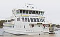 A normal ferry boat
 -
 Inner archipelago
 -
 "Middle" archipelago smaller island
 -
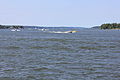
 Rather big distances between island
 -
 How people with there own boats transport themself


.jpg)
.jpg)

- This is still a new trail, and so far, I’m the only one who’s walked the entire route. I’ve started documenting guest harbors along the way using Wikidata query
- If we start to see others exploring new transport ideas between the sections, I’ll definitely share that. I just feel we might want to avoid dreaming up solutions that aren’t very realistic.
- Better support reader how to travel with ferries
- I came across an API trafiklab.se today - I guess the same data used by Google Maps for scheduled ferries. It could definitely be a useful resource, though it does seem like quite a big project! Maybe there's an alternative to Google—something that supports a multilingual UI and is a better fit for the kind of open, collaborative approach we're aiming for.
- Salgo60 (talk) 06:42, 12 June 2025 (UTC)
- One does not have to exclude the other. Ferries will no doubt be the main method that readers will choose to access the island, especially once the service pattern is explained in a bit more detail. Renting a boat could still prove useful to a select few. As the traveller comes first, we have a duty to at least provide them with the alternatives. That also means that we are fair to all methods of entry without a bias to any mode of transport. Yes, ferries are readily available, but to some, working out and planning public transit is a barrier to entry, and they might instead wish to hire a boat since it unties them from Waxholmsbolaget's service pattern. Our duty is not to plan the reader's visit for them, but to help them plan it themselves the way that they see fit.
― Wauteurz (talk) 08:15, 12 June 2025 (UTC)- Let's take a moment to see how others approach this and whether your suggestions on Wikivoyage align with practical experiences. If alternatives are included, it's important to also add the necessary qualifications, so people don’t unknowingly head in the wrong direction. After all, renting a boat comes with extra requirements—like
- a boating license or proof of competence
- the need of prior experience
- a security deposit
- knowledge of Swedish navigation laws
- Quite a bit of extra effort compared to just taking a walk in the archipelago! Maybe start an article about renting boats in the Swedish Archipelago and suggested things to do when you visit an island is to take a walk... Salgo60 (talk) 08:59, 12 June 2025 (UTC)
- I quickly checked the price tag
- Smaller boats (starting price): €210 per day
- Luxury boats (higher-end price): €4,020 per day
- Weekly sailboat rentals (lower range): €960 per week
- Weekly sailboat rentals (higher range): €2,440 per week
- Compared to Waxholms ferry ticket costs between €7.20 and €9.90 for a singel ticket and about 100 euro for a monthly ticket
- In addition you often have to pay for staying in the harbor = per night (€17–35)
- - Salgo60 (talk) 09:07, 12 June 2025 (UTC)
- Public transit is very intuitive to you or me, but there are plenty of people in the world that are not as used to having public transit available, or to using it. Fully relying on low-frequency public transit to get on and off an island therefore might be very intimidating and might become the main reason why some people don't commit to walking an Archipelago Trail. The average American, for example, would likely prefer the freedom to get themselves from A to B, regardless of that coming with an additional price tag of several thousand krona.
- As mentioned earlier in this discussion, Sweden does not require those in charge of a boat less than 12 metres long and 4 metres wide to have a license or proof of competence. In my experience with boat rentals (admittedly outside of Sweden), rental companies tend to inform you of the basic knowledge, as it's not in their interest that their boat ends up sinking. Really the only limitation therefore, would be the price tag. But sure, let's hear if others have objection to mentioning a possible alternative.
― Wauteurz (talk) 09:28, 12 June 2025 (UTC)- User:Salgo60, itemizing the price tag like that as of June 2025 is itself a service to would-be boat renters. Ikan Kekek (talk) 09:46, 12 June 2025 (UTC)
- We havnt seen any boat renters yet that is the problem ;-) Salgo60 (talk) 09:58, 12 June 2025 (UTC)
- User:Salgo60, itemizing the price tag like that as of June 2025 is itself a service to would-be boat renters. Ikan Kekek (talk) 09:46, 12 June 2025 (UTC)
- Many people – even if not a majority – do have prior experience, and Swedish navigation laws don't differ much from the international COLREG. The most important differences are spelled out in Boating on the Baltic Sea#Finland and Sweden. LPfi (talk) 10:14, 12 June 2025 (UTC)
- Public transport isnt intuitive for me either I have the last 20 years always relied on kayaking when exploring the archipelago even in the winter.
- You mention that price is the only real limitation when hiring a boat, but there are other factors to consider. Changing wind conditions and ice make navigation far more unpredictable compared to cruising a canal in the Netherlands. It’s not just about steering a boat; it’s about understanding the environment, anchoring properly, and handling potential challenges.
- I quickly checked the price tag
- Let's take a moment to see how others approach this and whether your suggestions on Wikivoyage align with practical experiences. If alternatives are included, it's important to also add the necessary qualifications, so people don’t unknowingly head in the wrong direction. After all, renting a boat comes with extra requirements—like
- One does not have to exclude the other. Ferries will no doubt be the main method that readers will choose to access the island, especially once the service pattern is explained in a bit more detail. Renting a boat could still prove useful to a select few. As the traveller comes first, we have a duty to at least provide them with the alternatives. That also means that we are fair to all methods of entry without a bias to any mode of transport. Yes, ferries are readily available, but to some, working out and planning public transit is a barrier to entry, and they might instead wish to hire a boat since it unties them from Waxholmsbolaget's service pattern. Our duty is not to plan the reader's visit for them, but to help them plan it themselves the way that they see fit.
- As for public transit being ‘low-frequency,’ that feels like a generalization. People live on these islands, and ferry services are designed to support them—not just occasional visitors.
- Personally, I’d have no trouble renting a boat in the Netherlands, but in the Swedish Archipelago, the responsibility is far greater. For me, kayaking remains the best option.
- I'll step out of this discussion now, as it doesn't really relate to the Walking Trail.
- I assume you are a member on the Netherland Wikipedia looks like I dont have permissions...
- This article https://nl.wikipedia.org/wiki/Stockholm_Archipelago_Trail maybe can get use of the maps with zoom
- I assume you are a member on the Netherland Wikipedia looks like I dont have permissions...
- I have added to maps to the following language versions a template like [Sjabloon:Maplink
- Good luck
- —The preceding comment was added by Salgo60 (talk • contribs) 12:01 12 June 2025 (UTC)
- As you told, kayaking requires experience. I am biased about boating, as I have rowed, sailed and spent days in our motorboat since before school age, but many locals just buy a boat and go boating – that extreme isn't to be recommended, but still, you can use a boat quite safely with only a good amount of respect and common sense. Weather forecasts are quite reliable regarding the general patterns a few days in advance, and if you moor in guest marinas, winds changing in the night are no big issue. Your main concern would be to check the weather forecasts, keep to the fairways, either at the right-hand side or steering predictably and giving way for other traffic, and to moor without crashing into other boats – quite easy if yours is small enough, you practice a bit and you respect the wind's effects. Anyway, there are those who do have skill and experience from before. –LPfi (talk) 10:29, 12 June 2025 (UTC)
I'm not entertaining this discussion any longer either since it's starting to go in circles, but I do wish to clarify and summarise some of what I've said before I step out.
- Low-frequency to me, is less than hourly. There seem to be a fair amount of those in the archipelago, as well as unintuitive operation patterns. That last one in particular would be a deal-breaker to me, even though public transit has been my main mode of travel for many years.
- I am generalising transport patterns just as much are you are generalising boating in the Netherlands.
- We can assume that people have common sense. You would not steer a boat into a storm as much as you wouldn't drive your car into a wall, or ride your bike off of a cliff.
- We do not assume the limitations of one's budget, nor their capabilities. We do not tell readers what to do and what not to do that isn't dictated by law. We do provide them with all possible options within reason. Renting a boat fits perfectly within reason, especially during the high season. Whether the traveller elects that option over the more common one, is up to the traveller and the traveller alone.
- This whole option of renting a boat isn't there to shift the focus of this article as you initially assumed. That focus will always be on the trails themselves. We have however, a duty to inform readers how to access the trails. The trails can be accessed by private boat. In this article we should therefore inform them where they could get a boat and what is required of them in that situation. Along with that information, the individual trail articles should list marinas and natural harbours, as they form access points to the islands, and therefore the islands' trails. I haven't gotten to adapting any of those individual trail articles, and at this point I am not sure whether I want to.
Lastly, I have not contributed to any Dutch Wikimedia projects to any notable extent in the past five years. Neither am I your workhorse.
― Wauteurz (talk) 11:02, 12 June 2025 (UTC)
Difficulty
The trail sections are described as easy, medium and difficult. The scale is in no way obvious (can a family with small children manage the easy sections? who should expect to manage the intermediate ones? do you need solid hiking experience and special equipment for the difficult one – I wouldn't think so, but somebody might). Could we have a description of what the levels mean, or a reference to somewhere where the levels are described, in Understand? –LPfi (talk) 06:59, 13 June 2025 (UTC)
- The difficulty levels used on the Stockholm Archipelago Trail follow their terminology: . Personally, after covering 270 km, I only found myself crawling two or three times, so I think the scale might be a bit exaggerated maybe ask them
- - Salgo60 (talk) 16:47, 13 June 2025 (UTC)
- Thanks. I added a link and a summary. The scale needs to cater to the target audience, and I suppose they have some feeling for it. If "difficult" doesn't sound right, one just have to adjust one's perception to the actual description (or to the facts on the ground, and describe it appropriately here). –LPfi (talk) 17:45, 13 June 2025 (UTC)
Many ferry stops are operated based on request.....
This sections is now wrong
> Many ferry stops are operated based on request. To request a ferry to stop and pick you up, use the semaphore at the bridge, putting it in an upright position. In some cases, semaphores are not provided and a ferry pick-up should be arranged by phone
Semaphores is not an indication if you need to call or not e.g. c:Category:Fjärdlång_ferry_stop - d:133993978 has a semaphore but you need to call sometimes and that is indicated in the swedish timetable e.g. s19 with a b e.g. "Beställ resan i SL-appen...."
-
 semaphore at Fjärdlången
.jpg)
I guess its better to delete it than its wrong... looks like version 5075898 was correct Salgo60 (talk) 18:49, 13 June 2025 (UTC)
- Better tell the whole truth: some need to be arranged by phone, but if there is a semaphore, you should use it, even if you called, and if there isn't, you should make sure you are clearly visible from the ferry. That's what I'd say about the Finnish archipelago ferries. –LPfi (talk) 19:51, 13 June 2025 (UTC)
Section Get_in and advice "renting a car"
More than confusing and I feel a bad advice in Get_in
The ferry stop for your destination is easily accessible by buses that align with the ferry schedule. While you can drive there, whickis normally faster parking is often a challenge, and it seems that many island summerhouse owners rent parking spaces at the ferry stop. From what I understand, the issue of cars and parking frequently comes up in conversations during boat trips as its a lot of planning.
Confusing line Most ferry stops are accessible by car as well as by public transit Every ferry stop you depart from on the "mainland" is accessible by bus and can also be reached by car, and the same applies in reverse.* busses are available on the island
- Stockholm Archipelago Trail/Ornö and Stockholm Archipelago Trail/Möja
- sometimes Stockholm Archipelago Trail/Landsort you have busses waiting in the ferry...
Salgo60 (talk) 19:27, 13 June 2025 (UTC)
- So there may or may not be free parking close to the ferry pier? Then we need to tell that, and perhaps advice against using a car that need to be parked. –LPfi (talk) 19:53, 13 June 2025 (UTC)
- In the Stockholm_Archipelago_Trail/Getting_in section, the green numbering indicates possible ferry stops to start from. I believe the focus should be on simply getting out and walking, rather than adding elements that might complicate the journey.
- Suggestions like renting boats or driving a rented car introduce uncertainty, especially when travelers may not know which ferry stop they'll end up at or whether parking will be readily available. A single line mentioning that buses and trains from Stockholm are generally aligned with ferry schedules and is the easiest way to travel might be more useful. Notably, the FAQ does not mention renting boats, cars, or even driving one's own car.
 Map of Stockholm Archipelago Trail
- 7 Dalarö --> Ornö, Fjärdlång, Gruvbryggan Utö.

- 8 Årsta --> Utö.
- 9 Nynäshamn --> Nåttarö Rånö Ålö.
- 10 Ankarudden --> Landsort.
- the same with the idea "Low-frequency to me, is less than hourly" that is the way if your out in the nature in Sweden and nothing that needs to be documented... more of interest is for people used to nature is where do they find drinking water so they dont have to cary so much...
- 7 Dalarö --> Ornö, Fjärdlång, Gruvbryggan Utö.
- - Salgo60 (talk) 20:44, 13 June 2025 (UTC)
- Have you looked much at other itinerary articles? Providing alternatives is far from inherently confusing, as long as they are presented in discrete sections.
- And by the way, you asked about linking to Commons and were told we don't do that; you were told we don't link to Google; and you were told we don't link to Mapillary. No other itinerary articles link to those sites. But have you deleted the links?
- You've provided a lot of content, but you seem to insist on doing it your own way, not in Wikivoyage:Style and regardless of what anyone else says and the fact that you are in the minority or sometimes a minority of one in discussions. That is not going to work and will sooner or later come to a head.
- I strongly recommend for you to treat wikis as collaborative sites and not just engage in discussions but pay attention to what others say, instead of seeing talk pages as places for you to repeatedly restate your preexisting views in different ways.
- And what about a proposal from you on how to deal with the replipunkt "article", which will not be deleted but has to be merged to an appropriate page that lacks a non-English word? It will not be left as is. Ikan Kekek (talk) 21:52, 13 June 2025 (UTC)
Explore the world

United states
New York

Japan
Tokyo

Singapore
Singapore
