
 Français
 Italiano
Размер этого предпросмотра: 592 × 599 пкс. Другие разрешения: 237 × 240 пкс | 474 × 480 пкс | 759 × 768 пкс | 1012 × 1024 пкс | 2116 × 2142 пкс.
Исходный файл (2116 × 2142 пкс, размер файла: 388 КБ, MIME-тип: image/png)
Краткое описание
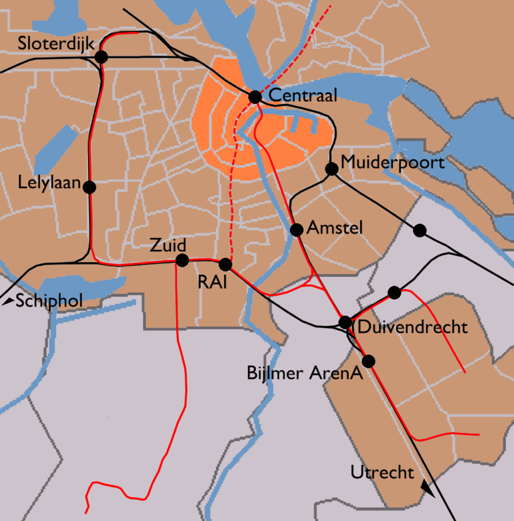
| Описание | English: Map of Amsterdam's train stations. Greyish orange background denotes the municipality of Amsterdam, bright orange is the Amsterdam-Centrum district. Black lines are railways and red lines are metro lines. Dashed red line is a metro line under construction (to be opened 2013). Black dots are the train stations.
|
| Дата | |
| Источник | Image modified by me, taken from Wikipedia Commons (Image:Outline map Amsterdam metro 2.PNG), which uses data from (and copyrighted by) the Dutch Centraal Bureau voor de Statistiek, which "allows anyone to use it for any purpose, provided that the copyright holder is properly attributed. Redistribution, derivative work, commercial use, and all other use is permitted." The map on Wikipedia was made by user Michiel1972, who placed his contribution in the public domain. I am doing the same for my modifications. |
| Автор | CBS, Michiel1972, me ((WT-shared) Mtcv) |
| Права (Повторное использование этого файла) | attribution required; PD This image is (in part or entirely) based on geographical data from Statistics Netherlands (Centraal Bureau voor de Statistiek). Digital geometry files in ESRI format can be downloaded from their website [1]. In particular, boundary data of statistical districts is based on either the Wijk- en buurtkaart 2005, or the Wijk- en buurtkaart 2003 ("CBS/TOPgrenzen"). Data on localities (bevolkingskernen) are from the publication Bevolkingskernen in Nederland 2001. Conditions of use (in Dutch):
|
Лицензирование
| Автор этого произведения, User: (WT-shared) Mtcv из wts викигид, передаёт его в общественное достояние. Это разрешение действует по всему миру. В некоторых странах это не может быть возможно юридически, в таком случае: User: (WT-shared) Mtcv из wts викигид предоставляет любому право использовать данное произведение в любых целях, без каких-либо условий, если только такие условия не требуются по закону.
|
Исходный журнал загрузок
| This file was imported from Wikivoyage WTS. |
Первоначальная страница описания находилась здесь. Все нижеперечисленные имена участников относятся к wts.wikivoyage-old.
- 2007-12-03 14:03 (WT-shared) Mtcv[недоступная ссылка] 2116×2142 (397547 bytes) {{Information |description=Map of Amsterdam's train stations. |source=Image modified by me, taken from Wikipedia Commons ([http://commons.wi (Import from wikitravel.org/shared)
История файла
Нажмите на дату/время, чтобы увидеть версию файла от того времени.
| Дата/время | Миниатюра | Размеры | Участник | Примечание | |
|---|---|---|---|---|---|
| текущий | 23:08, 17 ноября 2012 | | 2116 × 2142 (388 КБ) | MGA73bot2 | {{BotMoveToCommons|wts.oldwikivoyage|year={{subst:CURRENTYEAR}}|month={{subst:CURRENTMONTHNAME}}|day={{subst:CURRENTDAY}}}} == {{int:filedesc}} == {{Information |description=Map of Amsterdam's train stations. Greyish orange background denotes the munic... |
Использование файла
Следующая страница использует этот файл:
Глобальное использование файла
Данный файл используется в следующих вики:
Метаданные
Explore the world

United states
New York

Japan
Tokyo

Singapore
Singapore
