
 Français
 Italiano
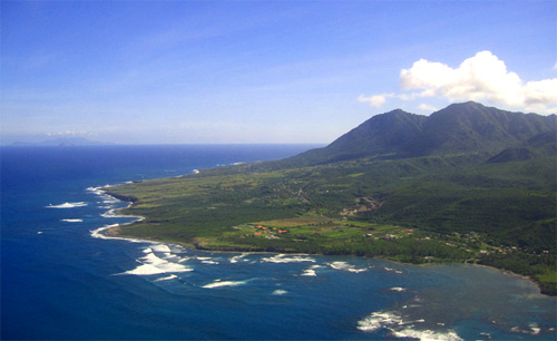
Grafika w wyższej rozdzielczości nie jest dostępna.
Nevis_Aerial.jpg (500 × 306 pikseli, rozmiar pliku: 51 KB, typ MIME: image/jpeg)
Opis
| Opis | English: Aerial shot taken from the northeast, depicting the east coast of the island of Nevis, Saint James Windward Parish, Saint Kitts and Nevis, West Indies. Long Haul Bay in the foreground. The islands of Redonda and Montserrat are visible at the horizon. |
| Data | |
| Źródło | Praca własna |
| Autor | Aaron Vos |
Licencja
Ten plik udostępniony jest na licencji Creative Commons Uznanie autorstwa – Na tych samych warunkach 2.5.
Uznanie autorstwa: Aaron Vos
- Wolno:
- dzielić się – kopiować, rozpowszechniać, odtwarzać i wykonywać utwór
- modyfikować – tworzyć utwory zależne
- Na następujących warunkach:
- uznanie autorstwa – musisz określić autorstwo utworu, podać link do licencji, a także wskazać czy utwór został zmieniony. Możesz to zrobić w każdy rozsądny sposób, o ile nie będzie to sugerować, że licencjodawca popiera Ciebie lub Twoje użycie utworu.
- na tych samych warunkach – Jeśli zmienia się lub przekształca niniejszy utwór, lub tworzy inny na jego podstawie, można rozpowszechniać powstały w ten sposób nowy utwór tylko na podstawie tej samej lub podobnej licencji.
Oryginalny rejestr przesyłania
All following user names refer to en.wikipedia.
- 2006-06-09 07:01 Pia L 500×306× (51 KB) (Attribution: Photo by Aaron Vos {{Cc-by-sa-2.5|Attribution details.}} Subject: Aerial shot depicting the southeast coast of the island of Nevis, Saint James Windward Parish, Nevis, West Indies. Date: 27 December 2005. Original digital photograph, uploaded)
Historia pliku
Kliknij na datę/czas, aby zobaczyć, jak plik wyglądał w tym czasie.
| Data i czas | Miniatura | Wymiary | Użytkownik | Opis | |
|---|---|---|---|---|---|
| aktualny | 13:05, 16 lut 2011 | | 500 × 306 (51 KB) | Telim tor | == {{int:filedesc}} == {{Information |Description={{en|Aerial shot taken from the northeast, depicting the east coast of the island of Nevis, Saint James Windward Parish, Saint Kitts and Nevis, West Indies. Long Haul Bay in the foreground. The islands of |
Lokalne wykorzystanie pliku
Poniższa strona korzysta z tego pliku:
Globalne wykorzystanie pliku
Ten plik jest wykorzystywany także w innych projektach wiki:
- Wykorzystanie na ang.wikipedia.org
- Wykorzystanie na be.wikipedia.org
- Wykorzystanie na br.wikipedia.org
- Wykorzystanie na da.wikipedia.org
- Wykorzystanie na el.wikipedia.org
- Wykorzystanie na en.wikipedia.org
- Wykorzystanie na en.wikiversity.org
- Wykorzystanie na en.wikivoyage.org
- Wykorzystanie na fi.wikipedia.org
- Wykorzystanie na he.wikipedia.org
- Wykorzystanie na hy.wikipedia.org
- Wykorzystanie na it.wikivoyage.org
- Wykorzystanie na lt.wikipedia.org
- Wykorzystanie na nn.wikipedia.org
- Wykorzystanie na pl.wikipedia.org
- Wykorzystanie na pl.wiktionary.org
- Wykorzystanie na ro.wikipedia.org
- Wykorzystanie na ru.wikipedia.org
- Wykorzystanie na sh.wikipedia.org
- Wykorzystanie na sr.wikipedia.org
- Wykorzystanie na sv.wikipedia.org
- Wykorzystanie na ta.wikipedia.org
- Wykorzystanie na th.wikipedia.org
- Wykorzystanie na tr.wikipedia.org
- Wykorzystanie na zh.wikipedia.org
Metadane
Explore the world

United states
New York

Japan
Tokyo

Singapore
Singapore
