
 Français
 Italiano
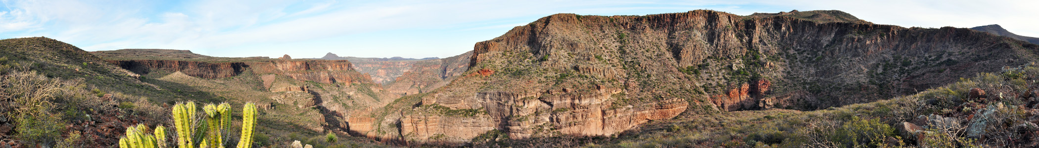
Rozmiar podglądu – 798 × 114 pikseli. Inne rozdzielczości: 320 × 46 pikseli | 2100 × 300 pikseli.
Rozmiar pierwotny (2100 × 300 pikseli, rozmiar pliku: 356 KB, typ MIME: image/jpeg)
Opis
| Opis | English: 270° Panorama of a river-carved canyon in the Sierra de San Francisco mountain range, in the northern region of Baja California Sur state on the Baja California Peninsula, Mexico. *The canyon valley and river drops towards the village of Santa Teresita on the left. *The far right leads to the mountain village of San Francisco de la Sierra, the locale of numerous prehistoric rock art pictographs, the Rock Paintings of Sierra de San Francisco. *The flora (plants) is of the Baja California Desert ecoregion. The Sierra de San Francisco are in the Peninsular Ranges system. |
| Data | (UTC) |
| Źródło | Ten plik jest pochodną pracą: San Francisco de la Sierra Canyon 270.jpg: |
| Autor |
|
Licencja
Ja, właściciel praw autorskich do tego dzieła, udostępniam je na poniższej licencji
Ten plik udostępniony jest na licencji Creative Commons Uznanie autorstwa 3.0.
- Wolno:
- dzielić się – kopiować, rozpowszechniać, odtwarzać i wykonywać utwór
- modyfikować – tworzyć utwory zależne
- Na następujących warunkach:
- uznanie autorstwa – musisz określić autorstwo utworu, podać link do licencji, a także wskazać czy utwór został zmieniony. Możesz to zrobić w każdy rozsądny sposób, o ile nie będzie to sugerować, że licencjodawca popiera Ciebie lub Twoje użycie utworu.
Oryginalny rejestr przesyłania
This image is a derivative work of the following images:
- File:San_Francisco_de_la_Sierra_Canyon_270.jpg licensed with Cc-by-3.0
- 2009-12-24T20:29:46Z Farwestern 13191x3386 (17526228 Bytes) {{Information |Description={{en|1=270° Panorama of a river-carved canyon in the [[San Francisco de la Sierra]] mountain range of [[Baja California]]. The canyon valley and river falls towards the village Santa Teresita. The
Historia pliku
Kliknij na datę/czas, aby zobaczyć, jak plik wyglądał w tym czasie.
| Data i czas | Miniatura | Wymiary | Użytkownik | Opis | |
|---|---|---|---|---|---|
| aktualny | 19:59, 23 lis 2013 | 2100 × 300 (356 KB) | Inkey | User created page with UploadWizard |
Lokalne wykorzystanie pliku
Poniższa strona korzysta z tego pliku:
Globalne wykorzystanie pliku
Ten plik jest wykorzystywany także w innych projektach wiki:
- Wykorzystanie na en.wikivoyage.org
- Wykorzystanie na eo.wikipedia.org
- Wykorzystanie na es.wikivoyage.org
- Wykorzystanie na fr.wikivoyage.org
- Wykorzystanie na it.wikivoyage.org
- Wykorzystanie na pt.wikivoyage.org
- Wykorzystanie na www.wikidata.org
Metadane
Explore the world

United states
New York

Japan
Tokyo

Singapore
Singapore
