
 Français
 Italiano
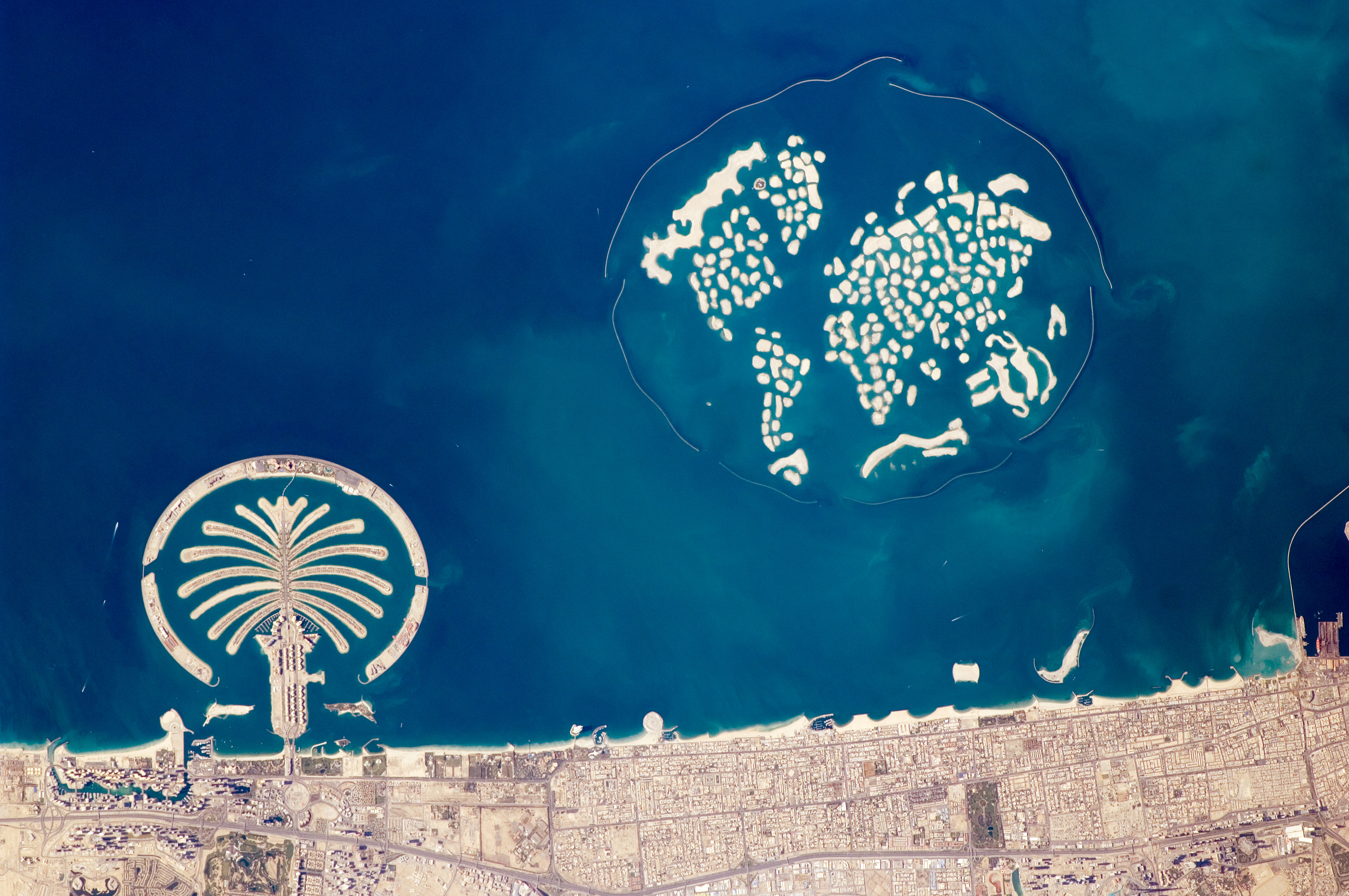
Rozmiar pierwotny (4288 × 2848 pikseli, rozmiar pliku: 5,08 MB, typ MIME: image/jpeg)
Opis
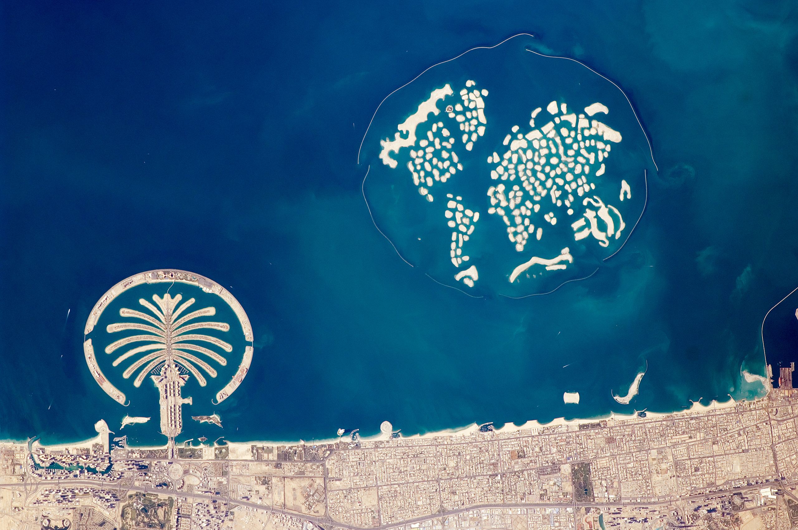
| Opis | العربية: مدينة دُبي هي أضخم مُدن منطقة الخليج العربي، وهي تقع في إمارةٍ تحملُ اسمها بِدولة الإمارات العربيَّة المُتحدة. حصدت المدينة سُمعة مهيبة حول العالم بِفضل مشاريعها الاقتصاديَّة والعُمرانيَّة الهائلة المُميزة التي جعلها موضع استقطابٍ كبير. من أبرز تلك المشاريع العُمرانيَّة—وبالأخص تلك التي يُمكن لِروَّاد الفضاء المُتمركزين في المحطة الفضائيَّة الدُوليَّة أن يروها—هي تلك الأرخبيلات الثلاثة بشريَّة الصُنع. تظهر جزيرتا النخيل (نخلة الجُميرة ونخلة جبل علي) وكأنهما منطبقتان على أسلوبٍ مُعيَّن عند النظر إليها من أعلى. أمَّا جُزر العالم فتستحضر خارطة العالم بالنسبة للناظر إليها من عُلوّ- أو عند التقاط صورةٍ لها من الفضاء. نخلة الجُميرة وجُزر العالم تظهرا في هذه الصورة التي التقطها الرائد الفضائي. شُرع بالعمل على جزيرة نخلة الجُميرة (أسفل اليسار) في سنة 2001 وتطلَّب إنشائها أكثر من 50 مليون متر مُكعَّب من الرمال المجروفة لِرفع الجزيرة فوق مُستوى مياه الخليج العربي. اكتُمل العمل على هذه الجزيرة في سنة 2006؛ وفي الوقت الحالي يتم تطوير كِلا الجزيرتين للاستيطان البشري عبر تزويدها بما يلزم من البُنى التحتيَّة. ابتدأ العمل على إنشاء جُزر العالم البالغ عددها 300 جزيرة (أعلى اليمين) في سنة 2003 واكتملت سنة 2008، وتطلَّبت 320 متر مُكعَّب من الرمال و37 مليون طن من الصُخور لِتشييد الحاجز كاسر الأمواج المُحيط بها والبالغ طوله 27 كيلومترًا. بالكاد تُظهرُ هذه الصورة أيَّة أعمال تطوير أو إنشاء للبُنى التحتيَّة على الجُزر سالفة الذِكر. أيضًا يظهر في الطرف السُفلي للصورة معلمٌ آخر بارز—وهو بُرج خليفة(أسفل يمين الصورة بعد تدويرها بِحوالي 90 درجة). يرتفع بُرج خليفة 800 متر (2,600 قدم)، وهو حاليًّا أطول مبنى في العالم. تُظهرُ الصُورة جُزءًا بسيطًا من البُرج يكفي للتعرُّف عليه، وهو شكله المُستدق المُخطط وكذلك ظلِّه القاتم الأشبه بالإبرة والذي يتوجَّه ناحية الشمال الشرقي.English: The municipality of Dubai is the largest city of the Persian Gulf emirate of the same name, and has built a global reputation for large-scale developments and architectural works. Among the most visible of these developments—particularly from the perspective of astronauts on board the International Space Station—are three human-made archipelagos. The two Palm Islands (Palm Jumeirah and Palm Jebel Ali) appear as stylized palm trees when viewed from above. The World Islands evoke a rough map of the world from an air- or space-borne perspective. Palm Jumeirah and the World Islands are highlighted in this astronaut photograph. Palm Jumeirah (image lower left) was begun in 2001 and required more than 50 million cubic meters of dredged sand to raise the islands above the Persian Gulf sea level. Construction of the Palm Jumeirah islands was completed in 2006; the islands are now being developed for residential and commercial housing and infrastructure. Creation of the 300 World Islands (image upper right) was begun in 2003 and completed in 2008, using 320 million cubic meters of sand and 37 million tonnes of rock for the surrounding 27-kilometer-long protective breakwater. Little to no infrastructure development of The World is apparent in this astronaut photograph. Also visible at the lower edge of the astronaut photograph is another notable structure—the Burj Khalifa (image lower right and rotated 90 degrees in inset). Burj Khalifa stands 800 meters (2,600 feet) high, and it is currently the world’s tallest structure. The astronaut photograph captures enough detail to make out the tapering outline of the building as well as its dark, needle-like shadow pointing towards the northeast.
| ||||||||||||||||||||||||||||||||||||||||||||||||||
| Data | |||||||||||||||||||||||||||||||||||||||||||||||||||
| Źródło | http://earthobservatory.nasa.gov/IOTD/view.php?id=42477 and http://eol.jsc.nasa.gov/scripts/sseop/photo.pl?mission=ISS022&roll=E&frame=24940 | ||||||||||||||||||||||||||||||||||||||||||||||||||
| Autor | Member of the Expedition 22 crew. | ||||||||||||||||||||||||||||||||||||||||||||||||||
| Inne wersje | |||||||||||||||||||||||||||||||||||||||||||||||||||
.jpg)
.jpg)
Ta grafika lub film został skatalagowany przez Johnson Space Center Stanów Zjednoczonych Ameryki National Aeronautics and Space Administration (NASA)pod Photo ID: ISS022-E-024940. Ten szablon nie wskazuje stanu prawnego pliku. Standardowy szablon licencji jest nadal wymagany. Aby dowiedzieć się więcej, zajrzyj na stronę Commons:Licencja. Inne języki:
|
Wyróżnienia
|
Licencja
This file is in the public domain in the United States because it was created by the Image Science & Analysis Laboratory, of the NASA Johnson Space Center. NASA copyright policy states that "NASA material is not protected by copyright unless noted". (NASA media use guidelines or Conditions of Use of Astronaut Photographs). Photo source: ISS022-E-24940.
|
Historia pliku
Kliknij na datę/czas, aby zobaczyć, jak plik wyglądał w tym czasie.
| Data i czas | Miniatura | Wymiary | Użytkownik | Opis | |
|---|---|---|---|---|---|
| aktualny | 23:51, 30 cze 2014 | | 4288 × 2848 (5,08 MB) | Ras67 | high resolution, new rendered from NASA's raw data |
| 21:20, 2 lut 2010 |  | 1445 × 960 (707 KB) | Captain-tucker | {{Information |Description={{en|The municipality of Dubai is the largest city of the Persian Gulf emirate of the same name, and has built a global reputation for large-scale developments and architectural works. Among the most visible of these development |
Lokalne wykorzystanie pliku
Poniższa strona korzysta z tego pliku:
Globalne wykorzystanie pliku
Ten plik jest wykorzystywany także w innych projektach wiki:
- Wykorzystanie na ar.wikipedia.org
- بوابة:الإمارات العربية المتحدة/صورة مختارة/6
- بوابة:الوطن العربي/صورة مختارة/أرشيف
- بوابة:مجلس التعاون الخليجي/صورة مختارة/أرشيف
- ويكيبيديا:صور مختارة/الفضاء والكون/نظرة إلى الخلف
- ويكيبيديا:جائزة المنتج - النصف الثاني لعام 2015/لا روسا وباسم
- ويكيبيديا:ترشيحات الصور المختارة/الجزر الاصطناعية الإماراتية
- ويكيبيديا:صورة اليوم المختارة/ديسمبر 2015
- قالب:صورة اليوم المختارة/2015-12-13
- بوابة:الوطن العربي/صورة مختارة/54
- بوابة:مجلس التعاون الخليجي/صورة مختارة/19
- بوابة:الإمارات العربية المتحدة/صورة مختارة/أرشيف
- ويكيبيديا:صورة اليوم المختارة/يناير 2019
- قالب:صورة اليوم المختارة/2019-01-16
- ويكيبيديا:صورة اليوم المختارة/مايو 2020
- قالب:صورة اليوم المختارة/2020-05-08
- ويكيبيديا:صورة اليوم المختارة/أبريل 2023
- قالب:صورة اليوم المختارة/2023-04-24
- استصلاح الأراضي في دولة الإمارات العربية المتحدة
- Wykorzystanie na ban.wikipedia.org
- Wykorzystanie na bg.wikipedia.org
- Wykorzystanie na bn.wikipedia.org
- Wykorzystanie na bn.wikivoyage.org
- Wykorzystanie na cs.wikipedia.org
- Wykorzystanie na en.wikipedia.org
- Wykorzystanie na en.wikivoyage.org
- Wykorzystanie na es.wikipedia.org
- Wykorzystanie na es.wikivoyage.org
- Wykorzystanie na fa.wikipedia.org
- Wykorzystanie na fr.wikipedia.org
- Wykorzystanie na haw.wikipedia.org
- Wykorzystanie na he.wikipedia.org
- Wykorzystanie na hy.wikipedia.org
Pokaż listę globalnego wykorzystania tego pliku.
Metadane
Explore the world

United states
New York

Japan
Tokyo

Singapore
Singapore
