
 Français
 Italiano
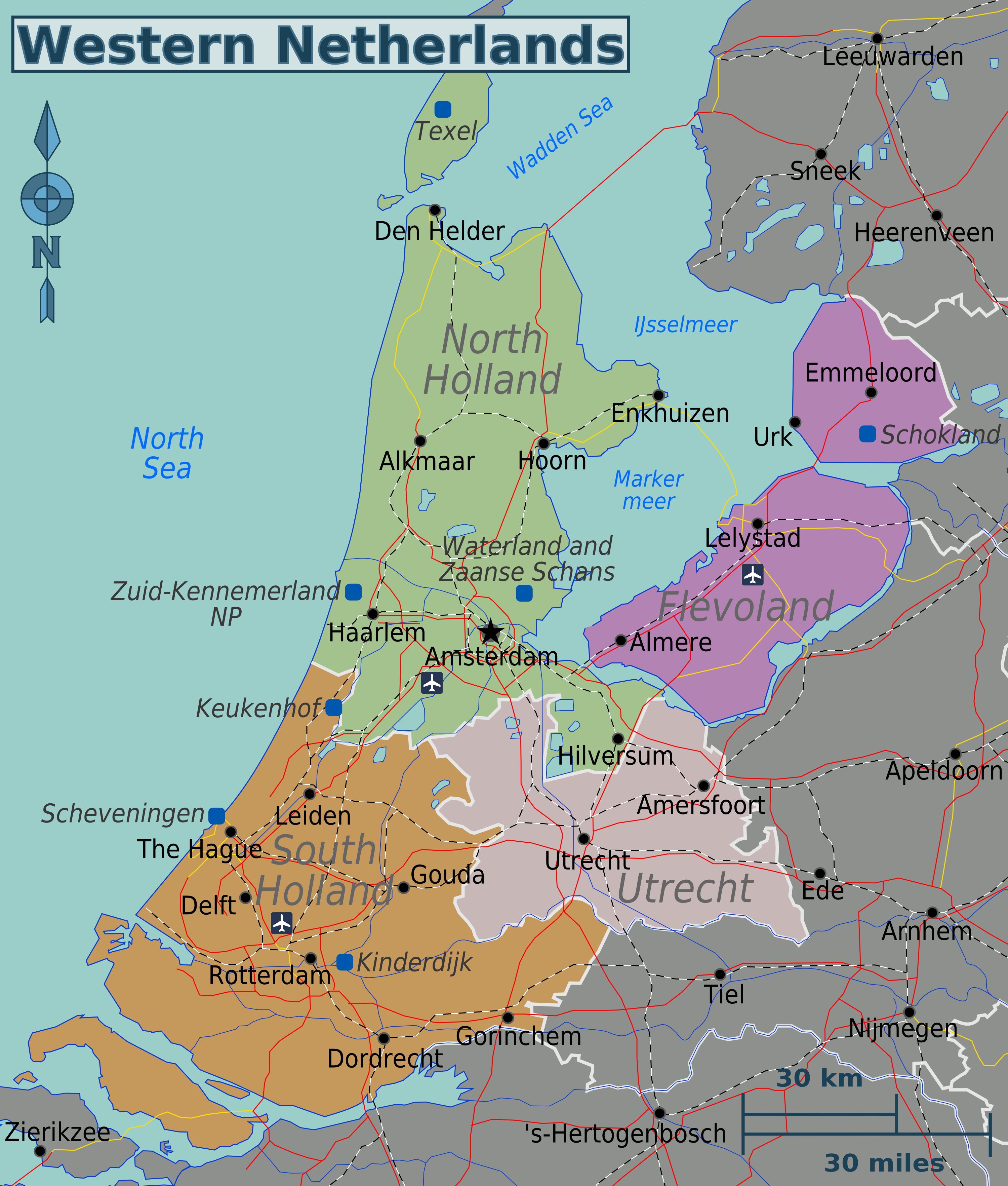
Grootte van deze voorvertoning: 510 × 600 pixels. Andere resoluties: 204 × 240 pixels | 408 × 480 pixels | 653 × 768 pixels | 871 × 1.024 pixels | 1.741 × 2.048 pixels | 2.999 × 3.527 pixels.
Oorspronkelijk bestand (2.999 × 3.527 pixels, bestandsgrootte: 2,01 MB, MIME-type: image/png)
Dit is een bestand van Wikimedia Commons. Onderstaande beschrijving komt van de beschrijving van het bestand daar. Commons is een vrij-gelicenceerde database voor afbeeldingen, geluid, video en andere bestanden. |
Beschrijving
| Beschrijving | English: Map of the Western Netherlands. |
| Datum | |
| Bron | Eigen werk based on University of Texas Library - Perry Castañeda Map Collection (public domain); ATB-kaart.png (public domain) by LennartBolks for rails; and SnelwegenNederland 2008.png (CC-BY-SA-3.0) by T Houdijk for roads. |
| Auteur | Globe-trotter |
| Andere versies | Western-netherlands-map.svg |
Licentie
Ik, de auteursrechthebbende van dit werk, maak het hierbij onder de volgende licentie beschikbaar:
Dit bestand is gelicenseerd onder de Creative Commons-licentie Naamsvermelding-Gelijk delen 3.0 Unported
- De gebruiker mag:
- Delen – het werk kopiëren, verspreiden en doorgeven
- Remixen – afgeleide werken maken
- Onder de volgende voorwaarden:
- naamsvermelding – U moet op een gepaste manier aan naamsvermelding doen, een link naar de licentie geven, en aangeven of er wijzigingen in het werk zijn aangebracht. U mag dit op elke redelijke manier doen, maar niet zodanig dat de indruk wordt gewekt dat de licentiegever instemt met uw werk of uw gebruik van zijn werk.
- Gelijk delen – Als u het materiaal remixt, transformeert of erop voortbouwt, moet u uw bijdragen verspreiden onder dezelfde licentie als die van het origineel, of een licentie die daarmee verenigbaar is.
Bestandsgeschiedenis
Klik op een datum/tijd om het bestand te zien zoals het destijds was.
| Datum/tijd | Miniatuur | Afmetingen | Gebruiker | Opmerking | |
|---|---|---|---|---|---|
| huidige versie | 20 jan 2013 09:21 | | 2.999 × 3.527 (2,01 MB) | Globe-trotter | higher resolution |
| 20 jan 2013 09:09 |  | 316 × 371 (110 kB) | Globe-trotter | {{Information |Description ={{en|1=Map of the Western Netherlands.}} |Source ={{own}} based on [http://www.lib.utexas.edu/maps/netherlands.html University of Texas Library - Perry Castañeda Map Collection] (public domain); [[:File:ATB-kaart... |
Bestandsgebruik
Dit bestand wordt op de volgende 2 pagina's gebruikt:
Globaal bestandsgebruik
Dit bestand wordt op de volgende andere wiki’s gebruikt:
- Gebruikt op el.wikivoyage.org
- Gebruikt op en.wikivoyage.org
- Gebruikt op he.wikivoyage.org
- Gebruikt op id.wikivoyage.org
- Gebruikt op incubator.wikimedia.org
- Gebruikt op it.wikivoyage.org
Metadata
Explore the world

United states
New York

Japan
Tokyo

Singapore
Singapore
