
 Français
 Italiano
Afmetingen van deze voorvertoning van het type PNG van dit SVG-bestand: 514 × 600 pixels Andere resoluties: 206 × 240 pixels | 411 × 480 pixels | 658 × 768 pixels | 878 × 1.024 pixels | 1.755 × 2.048 pixels | 744 × 868 pixels.
Oorspronkelijk bestand (SVG-bestand, nominaal 744 × 868 pixels, bestandsgrootte: 150 kB)
Dit is een bestand van Wikimedia Commons. Onderstaande beschrijving komt van de beschrijving van het bestand daar. Commons is een vrij-gelicenceerde database voor afbeeldingen, geluid, video en andere bestanden. |
Beschrijving
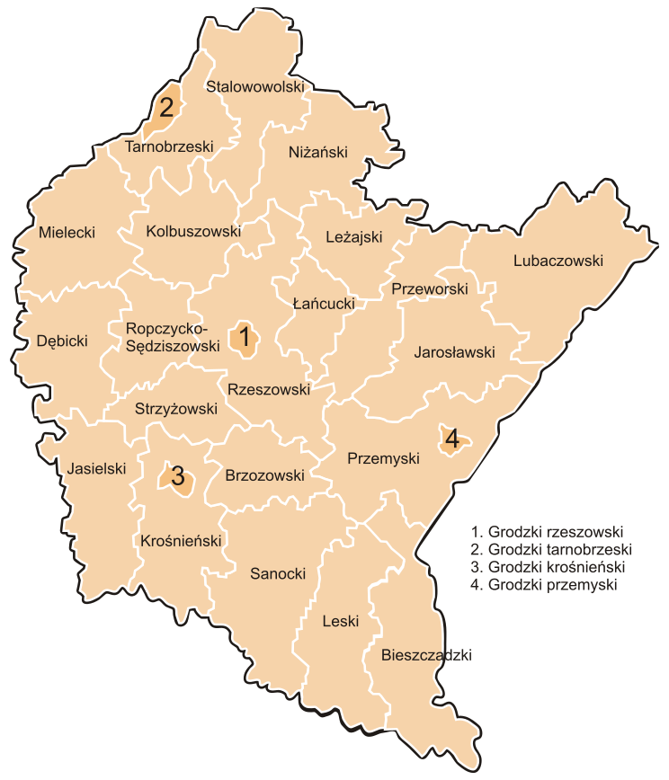
| Beschrijving | Polska - podział administracyjny, powiaty województwa podkarpackiego |
| Datum | |
| Bron | Eigen werk |
| Auteur | Krzysztof Kuba Wawrzosek (Kuba ads) |
| Andere versies | Afgeleide werken van dit bestand: Wikiekspedycja 2011 map.svg  |
Licentie
Ik, de auteursrechthebbende van dit werk, maak het hierbij onder de volgende licenties beschikbaar:
 | Toestemming wordt verleend voor het kopiëren, verspreiden en/of wijzigen van dit document onder de voorwaarden van de GNU-licentie voor vrije documentatie, versie 1.2 of enige latere versie als gepubliceerd door de Free Software Foundation; zonder Invariant Sections, zonder Front-Cover Texts, en zonder Back-Cover Texts. Een kopie van de licentie is opgenomen in de sectie GNU-licentie voor vrije documentatie. |
| Dit bestand is gelicenseerd onder de Creative Commons-licentie Naamsvermelding-Gelijk delen 3.0 Unported | ||
| ||
| Deze licentietag is toegevoegd aan dit bestand in verband met de GFDL licentie-update. |
U mag zelf één van de licenties kiezen.
Bestandsgeschiedenis
Klik op een datum/tijd om het bestand te zien zoals het destijds was.
| Datum/tijd | Miniatuur | Afmetingen | Gebruiker | Opmerking | |
|---|---|---|---|---|---|
| huidige versie | 1 aug 2006 14:23 | | 744 × 868 (150 kB) | Kuba ads | |
| 18 jul 2006 12:20 |  | 2.480 × 2.894 (94 kB) | Kuba ads | {{Information |Description=Polska - podział administracyjny, powiaty województwa podkarpackiego |Source=own work |Date=18.07.2006 |Author=Krzysztof Kuba Wawrzosek Kuba ads |Permission={{GFDL-self}} |other_versions= }} Category:Maps of Poland |
Bestandsgebruik
Dit bestand wordt op de volgende pagina gebruikt:
Globaal bestandsgebruik
Dit bestand wordt op de volgende andere wiki’s gebruikt:
- Gebruikt op af.wikipedia.org
- Gebruikt op ar.wikipedia.org
- Gebruikt op ban.wikipedia.org
- Gebruikt op be.wikipedia.org
- Gebruikt op bg.wikipedia.org
- Gebruikt op da.wikipedia.org
- Gebruikt op fa.wikipedia.org
- Gebruikt op fi.wikipedia.org
- Gebruikt op hu.wikipedia.org
- Gebruikt op id.wikipedia.org
- Gebruikt op it.wikipedia.org
- Gebruikt op jv.wikipedia.org
- Gebruikt op ko.wikipedia.org
- Gebruikt op lv.wikipedia.org
- Gebruikt op mk.wikipedia.org
- Gebruikt op myv.wikipedia.org
- Gebruikt op pl.wikipedia.org
- Gebruikt op pl.wikibooks.org
- Gebruikt op ps.wikipedia.org
- Gebruikt op ro.wikipedia.org
- Gebruikt op ru.wikipedia.org
- Gebruikt op simple.wikipedia.org
- Gebruikt op sk.wikipedia.org
- Gebruikt op tr.wikipedia.org
- Gebruikt op udm.wikipedia.org
- Gebruikt op uk.wikipedia.org
- Gebruikt op ur.wikipedia.org
- Gebruikt op zh.wikipedia.org
Explore the world

United states
New York

Japan
Tokyo

Singapore
Singapore
