
 Français
 Italiano
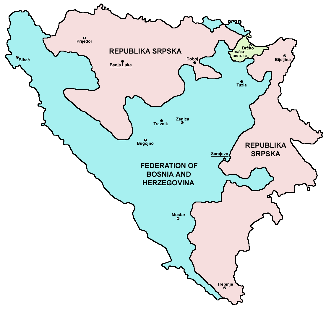
Grootte van deze voorvertoning: 633 × 599 pixels. Andere resoluties: 254 × 240 pixels | 507 × 480 pixels | 811 × 768 pixels | 1.103 × 1.044 pixels.
Oorspronkelijk bestand (1.103 × 1.044 pixels, bestandsgrootte: 67 kB, MIME-type: image/png)
Dit is een bestand van Wikimedia Commons. Onderstaande beschrijving komt van de beschrijving van het bestand daar. Commons is een vrij-gelicenceerde database voor afbeeldingen, geluid, video en andere bestanden. |
Beschrijving
| Beschrijving | Srpskohrvatski / српскохрватски: Federacija Bosne i Hercegovine, Republika Srpska i Distrikt Brčko / Федерација Босне и Херцеговине, Република Српска и Дистрикт Брчко. |
| Datum | |
| Bron | en:Image:M_bih03.png |
| Auteur | User:PANONIAN |
| Andere versies | []
|


.png)


References
- Slobodan Radovanović, Geografski atlas, Magic Map, Smederevska Palanka, 2001.
- Geografski atlas, Intersistem kartografija, Beograd, 2004.
- http://www.mapsofworld.com/bosnia/maps/bosnia-herzegovina-map.jpg
- http://www.slobodanjovanovic.org/wp-content/uploads/2009/12/bosna-kantoni1.jpg[dead link]
- http://www.thomasgraz.net/glass/map-BIH.gif
- http://aceproject.org/ero-en/regions/europe/BA/doc1.jpg/image
- United States Department of State
- http://www.visitbosnia.org/bih/images/stories/o_bih/drzavno_uredjenje/entiteti.jpg[dead link]
- http://www.conflictgeographies.org/uploads/2/6/1/8/2618869/8958714.jpg?490 archief kopie op de Wayback Machine
- http://vozi.org/images/stories/broj%20registrovanih%20vozila%202010.godina.png
- http://www.ohr.int/ohr-offices/brcko/images/map-brcko-district.jpg
- http://www.ohr.int/ohr-offices/brcko/images/mapa%20BD.JPG
- http://www.conflictgeographies.org/uploads/2/6/1/8/2618869/388168.jpg?490 archief kopie op de Wayback Machine
- http://world-gazetteer.com/ archief kopie op de Wayback Machine
Licentie
| Ik, de auteursrechthebbende van dit werk, geef dit werk vrij in het publieke domein. Dit is wereldwijd van toepassing. In sommige landen is dit wettelijk niet mogelijk; in die gevallen geldt: Ik sta iedereen toe dit werk voor eender welk doel te gebruiken, zonder enige voorwaarden, tenzij zulke voorwaarden door de wet worden voorgeschreven. |
 | Deze kaartafbeelding zou opnieuw moeten worden aangemaakt als een SVG-bestand door vectorafbeeldingen te gebruiken. Dit heeft een aantal voordelen; zie Commons:Media for cleanup voor meer informatie. Als er een SVG-formaat van deze afbeelding bestaat, dan deze graag uploaden. Nadat u dit heeft gedaan, gelieve dit sjabloon te vervangen door het sjabloon {{vector version available|nieuwe bestandsnaam.svg}} op deze afbeeldingspagina. |
Bestandsgeschiedenis
Klik op een datum/tijd om het bestand te zien zoals het destijds was.
| Datum/tijd | Miniatuur | Afmetingen | Gebruiker | Opmerking | |
|---|---|---|---|---|---|
| huidige versie | 6 jul 2010 23:38 | | 1.103 × 1.044 (67 kB) | WikiEditor2004 | Reverted to version as of 23:51, 12 March 2010 - I do not agree that these are better colours. it is subjective opinion and it is bad idea that every user should upload new file version because he have different opinion about "better" colours |
| 6 jul 2010 14:26 |  | 1.103 × 1.044 (58 kB) | Mostarac | better colors | |
| 6 jul 2010 14:25 |  | 1.103 × 1.044 (58 kB) | Mostarac | better colors and cities. | |
| 13 mrt 2010 01:51 |  | 1.103 × 1.044 (67 kB) | Dungodung | Well, I beg to differ. This one shows cities and is of better quality | |
| 9 mrt 2010 13:55 |  | 700 × 615 (172 kB) | Mostarac | revert, bolje boje! | |
| 20 dec 2009 23:10 |  | 1.103 × 1.044 (67 kB) | WikiEditor2004 | improved version | |
| 16 jul 2007 10:05 |  | 700 × 615 (13 kB) | Nihad Hamzic | This image was once a JPEG, the author had simply directly converted it to JPEG. I have grealty optimised its size by removing JPEG artifacts, and reducing color domain. | |
| 29 jan 2006 00:42 |  | 700 × 615 (172 kB) | (:Julien:) | Map of the 2 entities of the BiH and the Brčko district, author: en:User:PANONIAN, source: en:Image:M_bih03.png, PANONIAN is the creator and released it under PD. Category:Bosnia and Herzegovina |
Bestandsgebruik
Dit bestand wordt op de volgende pagina gebruikt:
Globaal bestandsgebruik
Dit bestand wordt op de volgende andere wiki’s gebruikt:
- Gebruikt op af.wikipedia.org
- Gebruikt op ami.wikipedia.org
- Gebruikt op am.wikipedia.org
- Gebruikt op arc.wikipedia.org
- Gebruikt op ar.wikipedia.org
- Gebruikt op arz.wikipedia.org
- Gebruikt op ast.wikipedia.org
- Gebruikt op az.wikipedia.org
- Gebruikt op bat-smg.wikipedia.org
- Gebruikt op be-tarask.wikipedia.org
- Gebruikt op bi.wikipedia.org
- Gebruikt op bjn.wikipedia.org
- Gebruikt op bn.wikipedia.org
- Gebruikt op bn.wikivoyage.org
- Gebruikt op bo.wikipedia.org
- Gebruikt op bpy.wikipedia.org
- Gebruikt op br.wikipedia.org
- Gebruikt op bs.wikipedia.org
- Gebruikt op ca.wikipedia.org
- Gebruikt op ceb.wikipedia.org
- Gebruikt op ce.wikipedia.org
- Gebruikt op ckb.wikipedia.org
- Gebruikt op co.wikipedia.org
- Gebruikt op crh.wikipedia.org
- Gebruikt op csb.wikipedia.org
- Gebruikt op cs.wikipedia.org
- Gebruikt op cs.wikinews.org
- Gebruikt op cv.wikipedia.org
- Gebruikt op cy.wikipedia.org
- Gebruikt op da.wikipedia.org
- Gebruikt op de.wikipedia.org
- Gebruikt op diq.wikipedia.org
- Gebruikt op dv.wikipedia.org
- Gebruikt op ee.wikipedia.org
- Gebruikt op el.wikipedia.org
- Gebruikt op en.wikipedia.org
- Bosnia and Herzegovina
- History of Bosnia and Herzegovina
- Multinational state
- Republika Srpska (1992–1995)
- Inter-Entity Boundary Line
- Talk:Inter-Entity Boundary Line
- Portal:Bosnia and Herzegovina
- User:Jonny-mt/Gallery of current first-level administrative country subdivisions maps
- Politics of country subdivisions
- Talk:Federation of Bosnia and Herzegovina/Archive 1
Globaal gebruik van dit bestand bekijken.
Explore the world

United states
New York

Japan
Tokyo

Singapore
Singapore
