
 Français
 Italiano
Afmetingen van deze voorvertoning van het type PNG van dit SVG-bestand: 512 × 393 pixels Andere resoluties: 313 × 240 pixels | 625 × 480 pixels | 1.001 × 768 pixels | 1.280 × 983 pixels | 2.560 × 1.965 pixels.
Oorspronkelijk bestand (SVG-bestand, nominaal 512 × 393 pixels, bestandsgrootte: 6,65 MB)
Dit is een bestand van Wikimedia Commons. Onderstaande beschrijving komt van de beschrijving van het bestand daar. Commons is een vrij-gelicenceerde database voor afbeeldingen, geluid, video en andere bestanden. |
Beschrijving
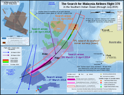
| Beschrijving | English: Map of the search areas for Malaysia Airlines Flight 370 in the Southern Indian Ocean (English). Not shown:
中文(中国大陆):本地图展示了南印度洋海域马来西亚航空370号班机的搜寻区域。(英文) 未展示出来的有:
| |||
| Datum | ||||
| Bron | Eigen werk The following sources were used for data included in the map. Locations (eg. where the search was conducted, locations of satellite debris & acoustic detections) are factual information which is not subject to copyright. Most sources are noted in the map. Main map
Towed Pinger Locator path & seafloor sonar survey location:
Background:
| |||
| Auteur | Andrew Heneen | |||
| Toestemming (Hergebruik van dit bestand) |
Ik, de auteursrechthebbende van dit werk, maak het hierbij onder de volgende licentie beschikbaar: Dit bestand is gelicenseerd onder de Creative Commons Naamsvermelding 4.0 Internationaal licentie.
| |||
| Andere versies |
| |||
| SVG ontwikkeling | De broncode van dit groot SVG-bestand is deugdelijk. |


| Aantekeningen | Deze afbeelding is aangetekend: Bekijk de aantekeningen op Commons |


Bestandsgeschiedenis
Klik op een datum/tijd om het bestand te zien zoals het destijds was.
| Datum/tijd | Miniatuur | Afmetingen | Gebruiker | Opmerking | |
|---|---|---|---|---|---|
| huidige versie | 17 dec 2017 11:45 | | 512 × 393 (6,65 MB) | JoKalliauer | removed rsvg-bug (flowtext), made file valid |
| 10 aug 2015 21:02 |  | 4.796 × 3.677 (6,76 MB) | AHeneen | fix typos | |
| 31 jul 2015 22:31 |  | 4.796 × 3.677 (6,75 MB) | AHeneen | Updated to 31 July 2015, including the expanded underwater search area (announced April 2015) and years were added to dates; to accommodate these changes, some unchanged elements were moved to different positions | |
| 13 dec 2014 08:50 |  | 4.796 × 3.677 (6,75 MB) | AHeneen | 30° label was not aligned properly | |
| 13 dec 2014 08:19 |  | 4.796 × 3.677 (6,75 MB) | AHeneen | minor adjustment to legend | |
| 9 dec 2014 09:03 |  | 4.796 × 3.677 (6,74 MB) | AHeneen | Remove "Background: Natural Earth" from lower right box | |
| 9 dec 2014 08:28 |  | 4.796 × 3.677 (6,74 MB) | AHeneen | Deleted hidden layers from SVG file (file size reduced about 40%)...now hopefully PNG preview issue is fixed | |
| 9 dec 2014 08:20 |  | 4.796 × 3.677 (10,43 MB) | AHeneen | changes that will hopefully fix an issue with rendering PNG preview | |
| 9 dec 2014 07:40 |  | 4.796 × 3.677 (10,43 MB) | AHeneen | Change to a color relief background with hillshade (now uses ETOPO1 data from NASA for bathymetry & Natural Earth for Australia outline); lat/long gradients are now vectors, which will hopefully resolve issues with them disappearing in PNG preview | |
| 8 dec 2014 04:44 |  | 4.796 × 3.677 (3,98 MB) | AHeneen | Additional flight paths & some clean up / improvements |
Bestandsgebruik
Geen enkele pagina gebruikt dit bestand.
Globaal bestandsgebruik
Dit bestand wordt op de volgende andere wiki’s gebruikt:
- Gebruikt op de.wikipedia.org
- Gebruikt op ro.wikipedia.org
Metadata
Explore the world

United states
New York

Japan
Tokyo

Singapore
Singapore
