
 Français
 Italiano
Afmetingen van deze voorvertoning van het type PNG van dit SVG-bestand: 322 × 598 pixels Andere resoluties: 129 × 240 pixels | 258 × 480 pixels | 413 × 768 pixels | 551 × 1.024 pixels | 1.102 × 2.048 pixels | 614 × 1.141 pixels.
Oorspronkelijk bestand (SVG-bestand, nominaal 614 × 1.141 pixels, bestandsgrootte: 176 kB)
Dit is een bestand van Wikimedia Commons. Onderstaande beschrijving komt van de beschrijving van het bestand daar. Commons is een vrij-gelicenceerde database voor afbeeldingen, geluid, video en andere bestanden. |
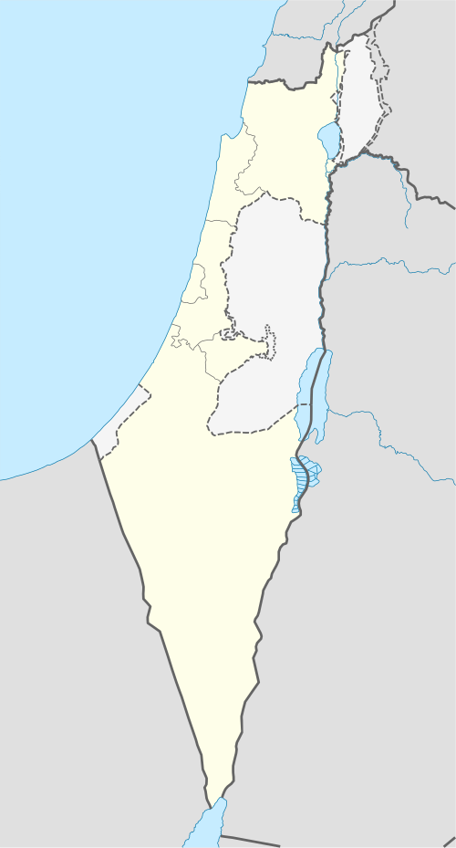
 | De grenzen op deze kaart tonen de de facto situatie. Dit is slechts een van de vele verschillende visies op het onderwerp (zie COM:NPOV). |
Beschrijving
| Beschrijving | Deutsch: Positionskarte von Israel. De-facto-Situation. Quadratische Plattkarte, N-S-Streckung 115 %. Geographische Begrenzung der Karte:
English: Location map of Israel. De facto situation. Equirectangular projection, N/S stretching 115%. Geographic limits of the map:
|
| Datum | |
| Bron | own work, using
|
| Auteur | NordNordWest |
| Andere versies | Afgeleide werken van dit bestand:
|


 | Deze kaart is gemaakt of verbeterd in de Duitse Kartenwerkstatt (Map Lab). Je kunt ook zelf kaarten ter verbetering voorstellen. |
Licentie
Ik, de auteursrechthebbende van dit werk, maak het hierbij onder de volgende licenties beschikbaar:
 | Toestemming wordt verleend voor het kopiëren, verspreiden en/of wijzigen van dit document onder de voorwaarden van de GNU-licentie voor vrije documentatie, versie 1.2 of enige latere versie als gepubliceerd door de Free Software Foundation; zonder Invariant Sections, zonder Front-Cover Texts, en zonder Back-Cover Texts. Een kopie van de licentie is opgenomen in de sectie GNU-licentie voor vrije documentatie. |
Dit bestand is gelicenseerd onder de Creative Commons-licentie Naamsvermelding-Gelijk delen 3.0 Unported
- De gebruiker mag:
- Delen – het werk kopiëren, verspreiden en doorgeven
- Remixen – afgeleide werken maken
- Onder de volgende voorwaarden:
- naamsvermelding – U moet op een gepaste manier aan naamsvermelding doen, een link naar de licentie geven, en aangeven of er wijzigingen in het werk zijn aangebracht. U mag dit op elke redelijke manier doen, maar niet zodanig dat de indruk wordt gewekt dat de licentiegever instemt met uw werk of uw gebruik van zijn werk.
- Gelijk delen – Als u het materiaal remixt, transformeert of erop voortbouwt, moet u uw bijdragen verspreiden onder dezelfde licentie als die van het origineel, of een licentie die daarmee verenigbaar is.
U mag zelf één van de licenties kiezen.
Bestandsgeschiedenis
Klik op een datum/tijd om het bestand te zien zoals het destijds was.
| Datum/tijd | Miniatuur | Afmetingen | Gebruiker | Opmerking | |
|---|---|---|---|---|---|
| huidige versie | 16 jun 2018 16:41 | | 614 × 1.141 (176 kB) | Jdx | Reverted to version as of 09:34, 16 June 2018 (UTC) |
| 16 jun 2018 16:05 |  | 614 × 1.141 (118 kB) | Beebbeebe | Reverted to version as of 00:41, 16 June 2018 (UTC) don't revert without motivating why your version is better | |
| 16 jun 2018 11:34 |  | 614 × 1.141 (176 kB) | NordNordWest | Reverted to version as of 20:16, 14 May 2018 (UTC); please write your hundred articles and respect Commons:Overwriting existing files | |
| 16 jun 2018 02:41 |  | 614 × 1.141 (118 kB) | Beebbeebe | Reverted to version as of 19:25, 14 May 2018 (UTC) The current map is simply incorrect. And I don't want to upload a new one, I'll have to edit more than a hundred wiki-articles. | |
| 14 mei 2018 22:16 |  | 614 × 1.141 (176 kB) | NordNordWest | Commons:Overwriting existing files#Controversial or contested changes even has to be respected by User:Eric's son | |
| 14 mei 2018 21:25 |  | 614 × 1.141 (118 kB) | Eric's son | Reverted to version as of 18:50, 10 March 2018 (UTC) | |
| 14 mei 2018 05:54 |  | 614 × 1.141 (176 kB) | Nableezy | Reverted to version as of 23:24, 5 March 2018 (UTC) yes you can, this map shows the occupied territories as separate make another if you want | |
| 10 mrt 2018 20:50 |  | 614 × 1.141 (118 kB) | Eric's son | Again, you cant compare gaza to golan. Reverted to version as of 00:44, 20 January 2018 (UTC) | |
| 6 mrt 2018 01:24 |  | 614 × 1.141 (176 kB) | Nableezy | Reverted to version as of 21:07, 14 April 2014 (UTC) restore convention of black lines for international borders and dashed lines for disputed boundaries | |
| 20 jan 2018 02:44 |  | 614 × 1.141 (118 kB) | Eric's son | Fixing small details in the green line |
Bestandsgebruik
Dit bestand wordt op de volgende pagina gebruikt:
Globaal bestandsgebruik
Dit bestand wordt op de volgende andere wiki’s gebruikt:
- Gebruikt op af.wikipedia.org
- Gebruikt op als.wikipedia.org
- Gebruikt op am.wikipedia.org
- Gebruikt op ar.wikipedia.org
- قائمة مدن إسرائيل
- تل أبيب
- باقة الغربية
- إيلات
- كفر قرع
- إجليل
- الجية
- العمارة (بئر السبع)
- إجزم (حيفا)
- مذبحة الدوايمة
- مذبحة بيت دراس
- بيت نبالا
- قالب:خريطة مواقع إسرائيل
- أم الفرج (فلسطين)
- مجزرة عين الزيتون
- خان الدوير
- ماروس
- سعسع (فلسطين)
- الكابري (فلسطين)
- السوافير الشمالية
- السوافير الشرقية
- الحرم (يافا)
- الجماسين الغربي
- الخيرية
- الحديثة (الرملة)
- حقل سارة وميرا
- مجزرة سعسع
- الجلمة (طولكرم)
- قالب:خريطة إسرائيل معلمة
- Gebruikt op av.wikipedia.org
Globaal gebruik van dit bestand bekijken.
Metadata
Explore the world

United states
New York

Japan
Tokyo

Singapore
Singapore
