
 Français
 Italiano
このプレビューのサイズ: 791 × 599 ピクセル。 その他の解像度: 317 × 240 ピクセル | 634 × 480 ピクセル | 1,014 × 768 ピクセル | 1,280 × 970 ピクセル | 2,560 × 1,940 ピクセル | 4,600 × 3,486 ピクセル。
元のファイル (4,600 × 3,486 ピクセル、ファイルサイズ: 5.35メガバイト、MIME タイプ: image/jpeg)
概要
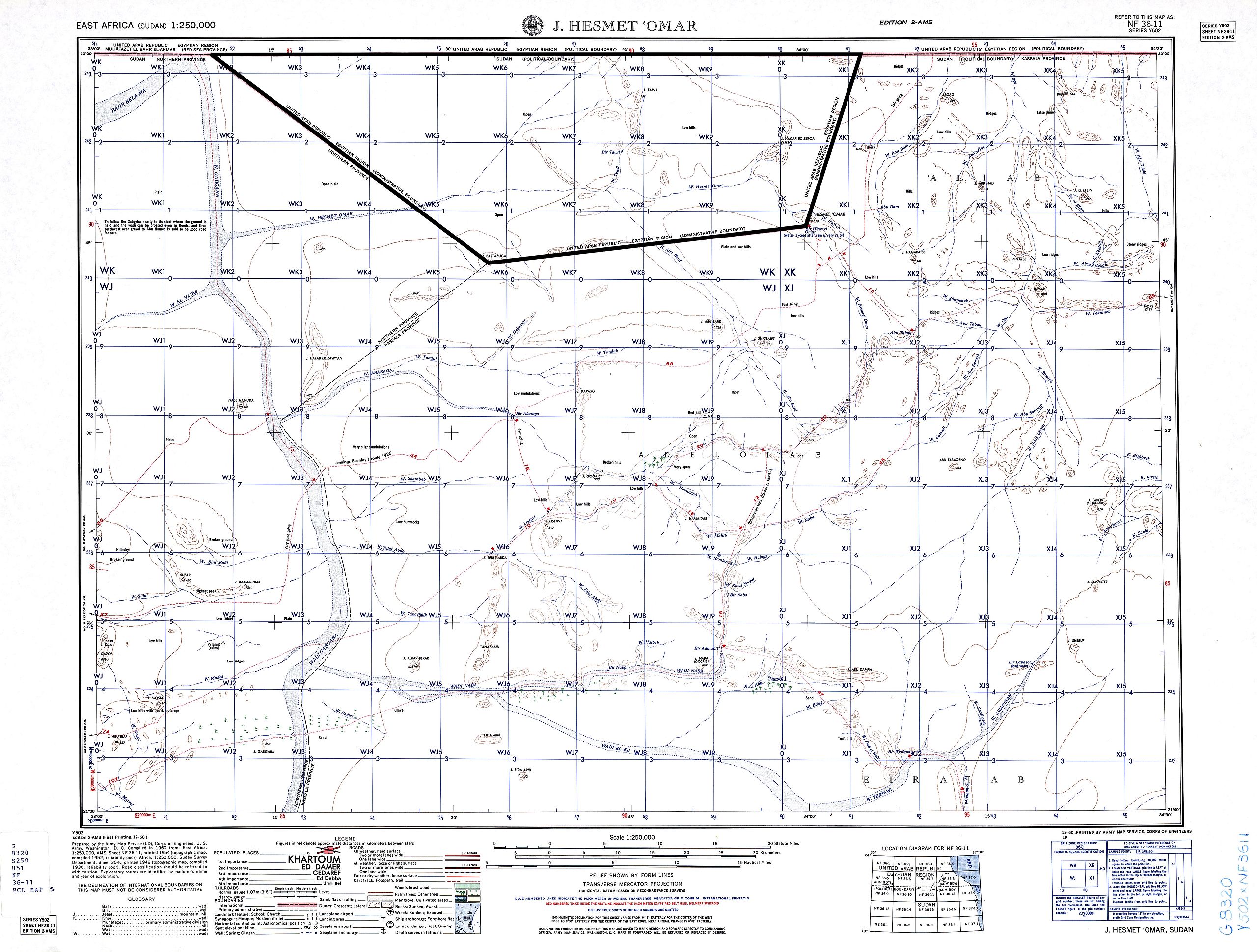
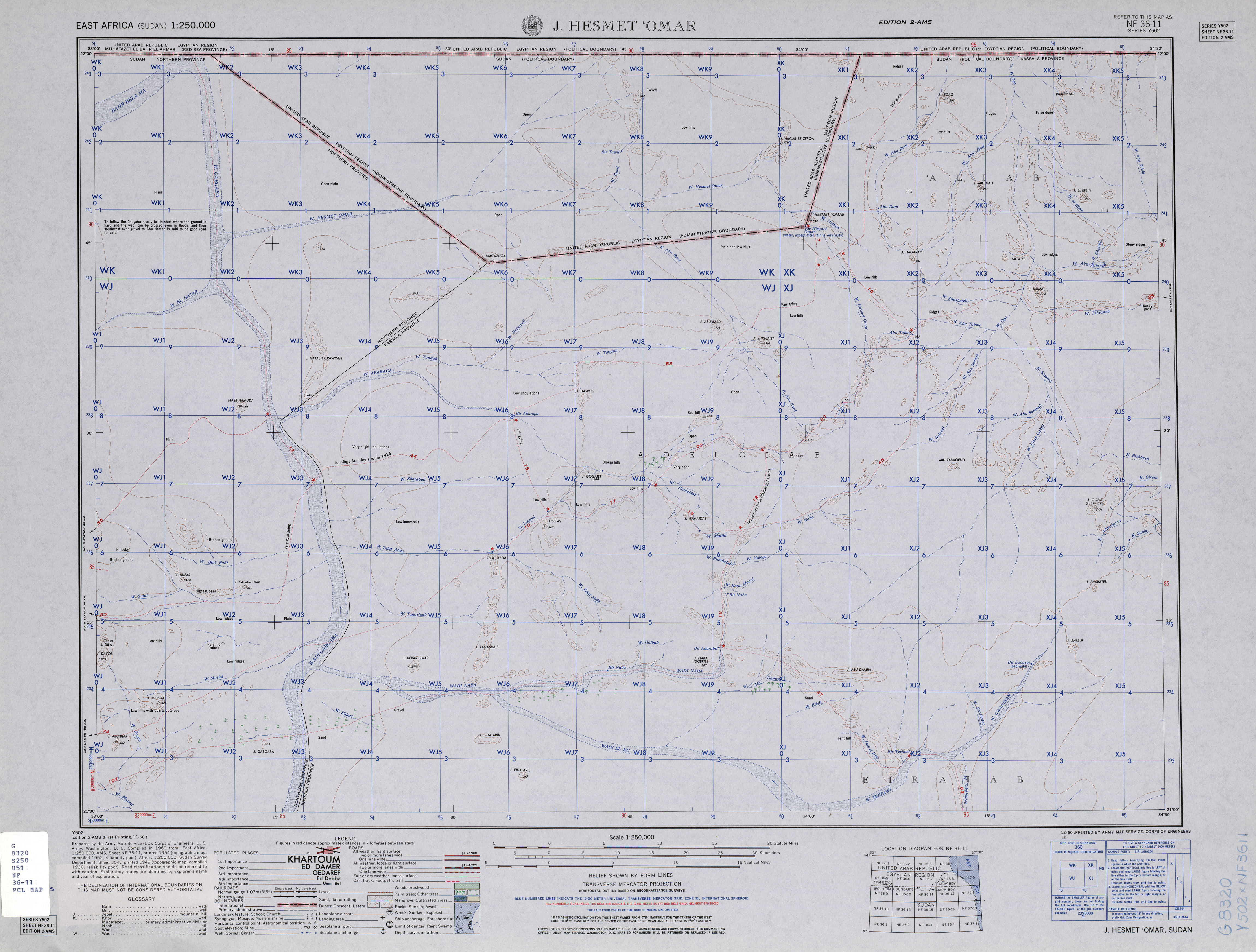
| 解説 | English: map of Bir Tawil area, Southern Egypt / Northern Sudan (no man's land) and area of northern Sudan to the south of it |
| 日付 | |
| 原典 | http://www.lib.utexas.edu/maps/ams/east_africa/txu-oclc-6594739-nf36-11.jpg |
| 作者 | Army Map Service, Corps of Engineers, U.S. Army |
ライセンス
|
|  |
ファイルの履歴
過去の版のファイルを表示するには、その版の日時をクリックしてください。
| 日付と時刻 | サムネイル | 寸法 | 利用者 | コメント | |
|---|---|---|---|---|---|
| 現在の版 | 2015年9月20日 (日) 13:15 | | 4,600 × 3,486 (5.35メガバイト) | Iaroslavvs | quadrangle (i.e. Bir Tawil's) boundaries highlighted |
| 2013年12月29日 (日) 13:52 |  | 4,600 × 3,486 (3メガバイト) | JasonAQuest | better contrast | |
| 2010年11月4日 (木) 14:17 |  | 4,600 × 3,486 (2.84メガバイト) | Thoroe | grey -> white | |
| 2010年5月29日 (土) 22:45 |  | 4,600 × 3,486 (2.8メガバイト) | Ratzer | {{Information |Description={{en|1=map of Bir Tawil area, Southern Egypt / Northern Sudan (no man's land) and area of northern Sudan to the south of it}} |Source=http://www.lib.utexas.edu/maps/ams/east_africa/txu-oclc-6594739-nf36-11.jpg |Author=Army Map S |
ファイルの使用状況
以下のページがこのファイルを使用しています:
グローバルなファイル使用状況
次に掲げる他のウィキでもこの画像を使用しています:
- ar.wikipedia.org での使用状況
- az.wikipedia.org での使用状況
- bg.wikipedia.org での使用状況
- de.wikipedia.org での使用状況
- el.wikipedia.org での使用状況
- fi.wikipedia.org での使用状況
- hy.wikipedia.org での使用状況
- it.wikipedia.org での使用状況
- ru.wikipedia.org での使用状況
- sr.wikipedia.org での使用状況
- uk.wikipedia.org での使用状況
- zh.wikipedia.org での使用状況
メタデータ
Explore the world

United states
New York

Japan
Tokyo

Singapore
Singapore
