
 Français
 Italiano
Dimensioni di questa anteprima PNG per questo file SVG: 631 × 599 pixel. Altre risoluzioni: 253 × 240 pixel | 505 × 480 pixel | 809 × 768 pixel | 1 078 × 1 024 pixel | 2 156 × 2 048 pixel | 2 129 × 2 022 pixel.
File originale (file in formato SVG, dimensioni nominali 2 129 × 2 022 pixel, dimensione del file: 2,53 MB)
| Questo file e la sua pagina di descrizione (discussione · modifica) si trovano su Wikimedia Commons (?) |
 | Questo file è stato trasferito su Wikimedia Commons da wts.oldwikivoyage utilizzando uno script per bot. Tutte le informazioni riguardanti la fonte del file sono ancora presenti. Tuttavia, necessitano di un controllo umano. Inoltre, potrebbero esserci degli errori nella visualizzazione di tutte le informazioni del file, dovuti alle differenze esistenti fra i template dei progetti Wikimedia. Di conseguenza, le informazioni su questo file non dovrebbero essere considerate attendibili e il file non dovrebbe essere riutilizzato finché non è stato controllato e finché tutte le correzioni necessarie non sono state fatte. Una volta eseguito il controllo, per favore rimuovi questo avviso. Per maggiori dettagli, vedi sotto. Controlla adesso! |
Dettagli
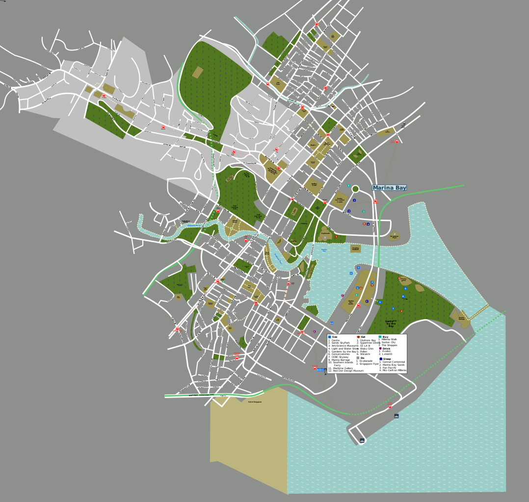
| Descrizione | Vector source file used to generated Singapore maps. By jpatokal, using standard Wikivoyage map template. PNG versions exported from this svg file.
|
| Data | 15 settembre 2007 (data di caricamento originaria) |
| Fonte | OSM + Opera propria |
| Autore | User: (WT-shared) Jpatokal di wts wikivoyage |
| Luogo | Singapore |
Licenza
Questo file è disponibile in base alla licenza Creative Commons Attribuzione-Condividi allo stesso modo 1.0 Generico
- Tu sei libero:
- di condividere – di copiare, distribuire e trasmettere quest'opera
- di modificare – di adattare l'opera
- Alle seguenti condizioni:
- attribuzione – Devi fornire i crediti appropriati, un collegamento alla licenza e indicare se sono state apportate modifiche. Puoi farlo in qualsiasi modo ragionevole, ma non in alcun modo che suggerisca che il licenziante approvi te o il tuo uso.
- condividi allo stesso modo – If you alter, transform, or build upon this work, you must distribute the resulting work under the same license as the original.
Registro originale del caricamento
| This file was imported from Wikivoyage WTS. |
La pagina di descrizione originale era qui. Tutti i nomi utente che seguono sono riferiti a wts.wikivoyage-old.
- 2007-09-15 14:05 (WT-shared) Jpatokal copia archiviata at the Wayback Machine 744×1052 (1325857 bytes) Vector source file used to generated Singapore maps. By jpatokal, using standard Wikitravel map template. {{location|Singapore}} (Import from wikitravel.org/shared)
- 2007-09-20 10:14 (WT-shared) Jpatokal copia archiviata at the Wayback Machine 744×1052 (1519654 bytes) Sep 2007 update complete (Import from wikitravel.org/shared)
- 2009-03-30 14:40 (WT-shared) Jpatokal copia archiviata at the Wayback Machine 744×1052 (1548109 bytes) (Import from wikitravel.org/shared)
- 2009-10-03 08:53 (WT-shared) Jpatokal copia archiviata at the Wayback Machine 744×1052 (1574076 bytes) Updated (Import from wikitravel.org/shared)
- 2012-09-13 11:42 ImportBot[collegamento interrotto] 744×1052 (1419675 bytes) rm WT-logo
Cronologia del file
Fare clic su un gruppo data/ora per vedere il file come si presentava nel momento indicato.
| Data/Ora | Miniatura | Dimensioni | Utente | Commento | |
|---|---|---|---|---|---|
| attuale | 14:58, 30 gen 2018 | | 2 129 × 2 022 (2,53 MB) | Drat70 | Updated Marina Bay area |
| 14:13, 20 nov 2017 |  | 2 129 × 2 022 (2,53 MB) | Drat70 | Updated Orchard area | |
| 14:59, 15 nov 2017 |  | 2 129 × 2 022 (2,5 MB) | Drat70 | Updated Brash Basah area | |
| 15:36, 23 ott 2017 |  | 2 129 × 2 022 (2,47 MB) | Drat70 | Updated listings/map for Riverside | |
| 16:09, 20 ott 2017 |  | 2 129 × 2 022 (2,47 MB) | Drat70 | Updated Clarke Quay area | |
| 14:26, 16 ott 2017 |  | 2 129 × 2 022 (2,47 MB) | Drat70 | Updated Chinatown | |
| 14:08, 9 ott 2017 |  | 2 129 × 2 022 (2,46 MB) | Drat70 | Updated places and roads in Little India area | |
| 14:35, 2 ott 2017 |  | 2 129 × 2 022 (2,43 MB) | Drat70 | Extended map into Marina Bay area added layer for Marina Bay area added remaining stations for Downtown line | |
| 08:21, 21 set 2017 |  | 744 × 1 052 (1,36 MB) | Drat70 | General update, mostly in the Bugis area: * removed/added buildings and roads which are not up to date * added Downtown line stations * updated Bugis layer to correspond to the Bugis wikivoyage article | |
| 15:22, 22 dic 2012 |  | 744 × 1 052 (1,35 MB) | OgreBot | (BOT): Reverting to most recent version before archival |
Utilizzo del file
Nessuna pagina utilizza questo file.
Utilizzo globale del file
Anche i seguenti wiki usano questo file:
- Usato nelle seguenti pagine di vi.wikipedia.org:
Metadati
Explore the world

United states
New York

Japan
Tokyo

Singapore
Singapore
