
 Français
 Italiano
Dimensioni di questa anteprima PNG per questo file SVG: 340 × 330 pixel. Altre risoluzioni: 247 × 240 pixel | 495 × 480 pixel | 791 × 768 pixel | 1 055 × 1 024 pixel | 2 110 × 2 048 pixel.
File originale (file in formato SVG, dimensioni nominali 340 × 330 pixel, dimensione del file: 83 KB)
| Questo file e la sua pagina di descrizione (discussione · modifica) si trovano su Wikimedia Commons (?) |
Dettagli
Questa grafica vettoriale non specificata secondo il W3C è stata creata con Inkscape .
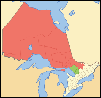
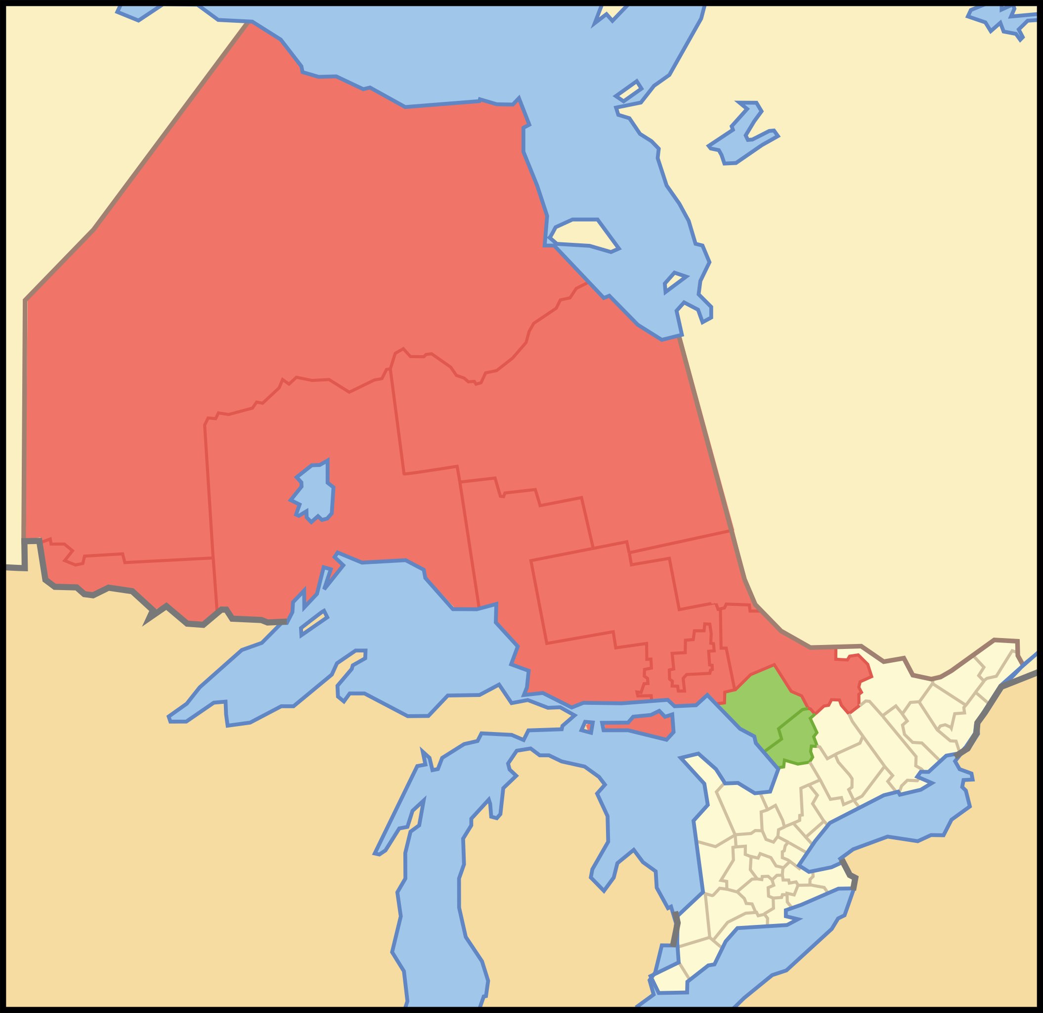
| Descrizione | Map showing en:Northern Ontario. Red is the districts always considered Northern Ontario. Green are the districts sometimes considered Northern Ontario. |
| Data | |
| Fonte | Crop and trace of Image:Canada (geolocalisation).svg; trace of Image:Ontario subdivisions.PNG. |
| Autore | Vidioman |
| Altre versioni | Image:Noront.PNG, Image:Northern Ontario Map Green.png |
.svg)
Licenza
| Io, detentore del copyright su quest'opera, la rilascio nel pubblico dominio. Questa norma si applica in tutto il mondo. In alcuni paesi questo potrebbe non essere legalmente possibile. In tal caso: Garantisco a chiunque il diritto di utilizzare quest'opera per qualsiasi scopo, senza alcuna condizione, a meno che tali condizioni siano richieste dalla legge. |
Cronologia del file
Fare clic su un gruppo data/ora per vedere il file come si presentava nel momento indicato.
| Data/Ora | Miniatura | Dimensioni | Utente | Commento | |
|---|---|---|---|---|---|
| attuale | 14:03, 12 ott 2007 | | 340 × 330 (83 KB) | Vidioman | {{Created with Inkscape}} {{Information |Description=Map showing Northern Ontario. Red is the districts always considered Northern Ontario. Green are the districts sometimes considered Northern Ontario. |Source=Crop and trace of [[:Image:Canada (geolocali |
Utilizzo del file
La seguente pagina usa questo file:
Utilizzo globale del file
Anche i seguenti wiki usano questo file:
- Usato nelle seguenti pagine di en.wikipedia.org:
- Northern Ontario
- Abitibi Canyon
- Acanthus, Ontario
- Achray, Ontario
- Adanac, Nipissing District, Ontario
- Unorganized South Nipissing District
- Whitefish Lake 6, Ontario
- List of proposed provinces and territories of Canada
- Centennial Park (Thunder Bay)
- Lake Manitou
- Sturgeon Falls
- Kiosk, Ontario
- Estaire, Ontario
- Kukatush, Ontario
- Prince, Ontario
- Cedar Lake (Nipissing District)
- Red Cedar Lake (Ontario)
- Wabigoon Lake
- Spence, Ontario
- Unorganized Kenora District
- Papineau-Cameron
- Calvin, Ontario
- Bridal Veil Falls (Manitoulin Island)
- Unorganized North Nipissing District
- Balsam Creek, Ontario
- Bear Island (Lake Temagami)
- Evanturel
- Tidewater Provincial Park
- Template:NorthernOntario-geo-stub
- Sudbury Downs
- Marten River, Ontario
- Chisholm, Ontario
- La Verendrye Provincial Park
- Opeongo River Provincial Park
- Sultan, Ontario
- Aroland First Nation
- Osnaburgh 63A
- Lount Township, Ontario
- Hollinger Park
- Ryerson, Ontario
- Joly, Ontario
- Burpee and Mills
- False Detour Channel
- Mississagi Strait
- Goat Island (Ontario)
- Maynard Lake
- Lac Seul
- Whitewater Lake
- Paradis Bay, Ontario
- Ojibway Provincial Park
Visualizza l'utilizzo globale di questo file.
Explore the world

United states
New York

Japan
Tokyo

Singapore
Singapore
