
 Français
 Italiano
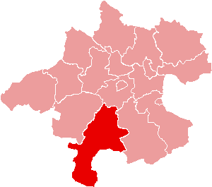
Non sono disponibili versioni a risoluzione più elevata.
Karte_Aut_Ooe_GM.png (300 × 265 pixel, dimensione del file: 4 KB, tipo MIME: image/png)
| Questo file e la sua pagina di descrizione (discussione · modifica) si trovano su Wikimedia Commons (?) |
Dettagli
| Descrizione | Location of Bezirk Gmunden within the Land of Upper Austria |
| Data | |
| Fonte | de:Bild:Karte Aut Ooe GM.png |
| Autore | de:Benutzer:Plp |
| Licenza (Riusare questo file) | GFDL-author (licence from German Wikipedia) |
| Altre versioni | de:Bild:Karte Aut Ooe GM.png |
Licenza
 | È permesso copiare, distribuire e/o modificare questo documento in base ai termini della GNU Free Documentation License, Versione 1.2 o successive pubblicata dalla Free Software Foundation; senza alcuna sezione non modificabile, senza testo di copertina e senza testo di quarta di copertina. Una copia della licenza è inclusa nella sezione intitolata Testo della GNU Free Documentation License. |
| Questo file è disponibile in base alla licenza Creative Commons Attribuzione-Condividi allo stesso modo 3.0 Unported | ||
| ||
| Questo tag di copyright è stato aggiunto nell'ambito dell'aggiornamento della licenza dei progetti Wikimedia. |
Cronologia del file
Fare clic su un gruppo data/ora per vedere il file come si presentava nel momento indicato.
| Data/Ora | Miniatura | Dimensioni | Utente | Commento | |
|---|---|---|---|---|---|
| attuale | 17:06, 23 giu 2006 | | 300 × 265 (4 KB) | Physchim62 | {{Information |Description=Location of Bezirk Gmunden within the Land of Upper Austria |Source=de:Bild:Karte Aut Ooe GM.png |Date=2004 |Author=de:Benutzer:Plp |Permission=GFDL- |
Utilizzo del file
Nessuna pagina utilizza questo file.
Utilizzo globale del file
Anche i seguenti wiki usano questo file:
- Usato nelle seguenti pagine di bs.wikipedia.org:
- Usato nelle seguenti pagine di ce.wikipedia.org:
- Альтмуьнстер
- Бад-Гойзерн
- Бад-Ишль
- Гмунден
- Гозау (Австри)
- Груьнау-им-Альмталь
- Гшвандт
- Кирххам (Лакха Австри)
- Лакирхен
- Обертраун
- Ольсдорф (Лакха Австри)
- Пинсдорф
- Ройтхам
- Санкт-Вольфганг-им-Зальцкаммергут
- Санкт-Конрад
- Траункирхен
- Форхдорф
- Халльштатт
- Шарнштайн
- Эбензе-ам-Траунзе
- Кеп:Австри:Гмунден гуо:ГӀаланаш
- Usato nelle seguenti pagine di cs.wikipedia.org:
- Usato nelle seguenti pagine di de.wikipedia.org:
- Usato nelle seguenti pagine di es.wikipedia.org:
- Usato nelle seguenti pagine di fa.wikipedia.org:
- Usato nelle seguenti pagine di fr.wikipedia.org:
- Ebensee am Traunsee
- Hallstatt
- Bad Ischl
- Gosau
- Altmünster
- Bad Goisern am Hallstättersee
- Gmunden
- Grünau im Almtal
- Gschwandt
- District de Gmunden
- Modèle:Palette District de Gmunden
- Vorchdorf
- Traunkirchen
- Scharnstein
- Sankt Wolfgang im Salzkammergut
- Sankt Konrad
- Roitham am Traunfall
- Pinsdorf
- Ohlsdorf
- Obertraun
Visualizza l'utilizzo globale di questo file.
Explore the world

United states
New York

Japan
Tokyo

Singapore
Singapore
