
 Français
 Italiano
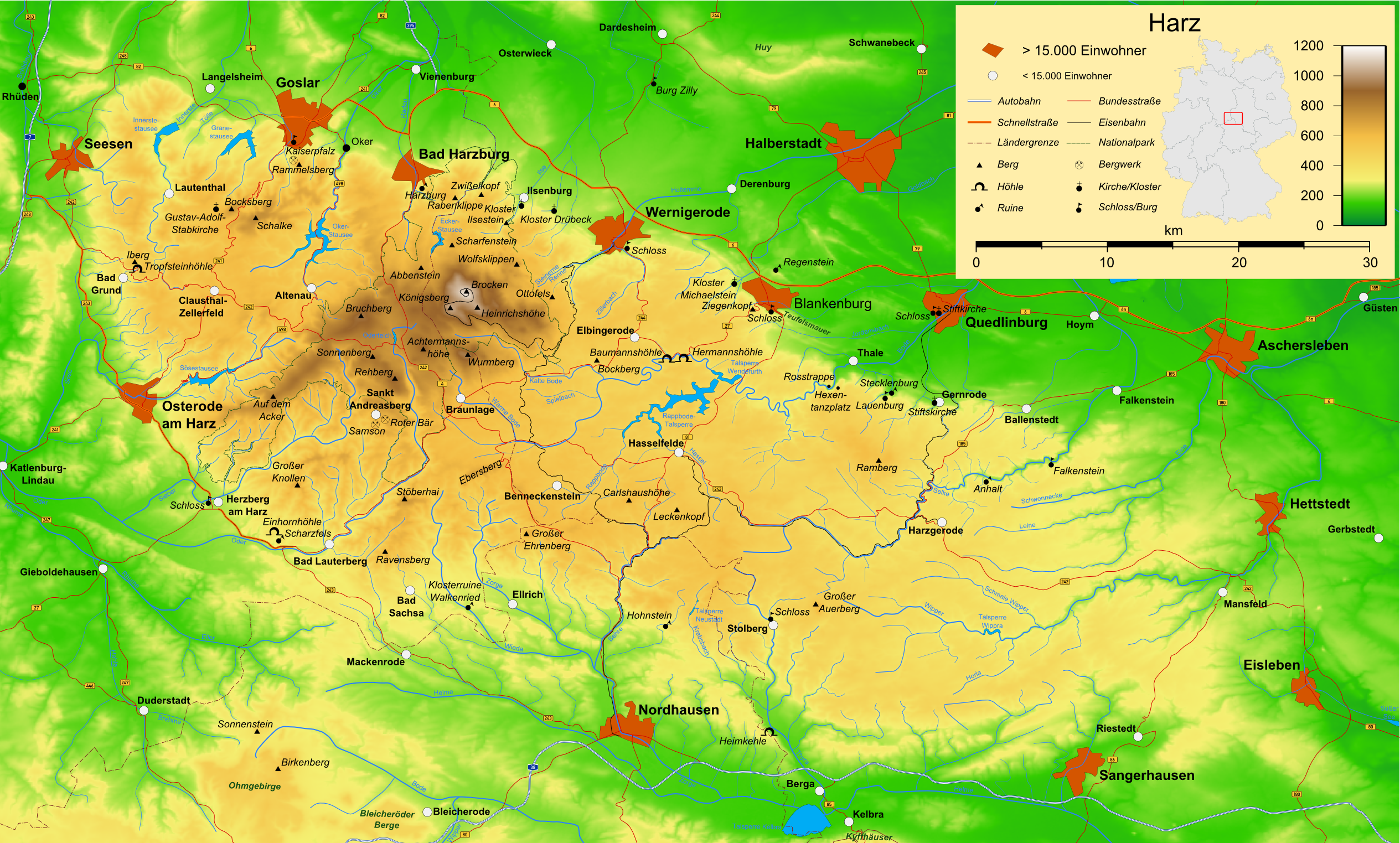
Dimensioni di questa anteprima: 800 × 482 pixel. Altre risoluzioni: 320 × 193 pixel | 640 × 385 pixel | 1 024 × 617 pixel | 1 280 × 771 pixel | 2 529 × 1 523 pixel.
File originale (2 529 × 1 523 pixel, dimensione del file: 3,15 MB, tipo MIME: image/png)
| Questo file e la sua pagina di descrizione (discussione · modifica) si trovano su Wikimedia Commons (?) |
Dettagli
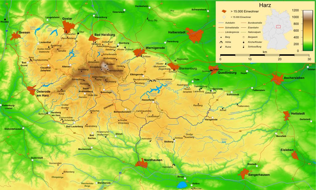
| Descrizione | Map of the Harz mountains in Germany with mountains, rivers, lakes, reservoirs, all highways, all Bundesstraßen, Harzquerbahn, Brockenbahn, Selketalbahn, major towns and sights. |
| Data | |
| Fonte | Opera propria |
| Autore | Bamse |
| Altre versioni | Opere derivate da questo file: Karte Harzer Schmalspurbahnen.png  , ,  , ,  |
La mappa è stata creata con Generic Mapping Tools: https://generic-mapping-tools.org/ usando una o più di queste banchedati in pubblico dominio per i rilievi:
|
 | È permesso copiare, distribuire e/o modificare questo documento in base ai termini della GNU Free Documentation License, Versione 1.2 o successive pubblicata dalla Free Software Foundation; senza alcuna sezione non modificabile, senza testo di copertina e senza testo di quarta di copertina. Una copia della licenza è inclusa nella sezione intitolata Testo della GNU Free Documentation License. |
| Questo file è disponibile in base alla licenza Creative Commons Attribuzione-Condividi allo stesso modo 3.0 Unported | ||
| ||
| Questo tag di copyright è stato aggiunto nell'ambito dell'aggiornamento della licenza dei progetti Wikimedia. |
 | Questa mappa è stata prodotta e/o migliorata nel Kartenwerkstatt, il laboratorio grafico della Wikipedia tedesca, dove è possible proporre mappe da migliorare. |
Cronologia del file
Fare clic su un gruppo data/ora per vedere il file come si presentava nel momento indicato.
| Data/Ora | Miniatura | Dimensioni | Utente | Commento | |
|---|---|---|---|---|---|
| attuale | 18:05, 15 dic 2009 | | 2 529 × 1 523 (3,15 MB) | Bamse | update, B6n is completed |
| 08:12, 14 dic 2007 |  | 2 529 × 1 523 (3,15 MB) | Bamse | {{Information |Description=Map of the Harz mountains in Germany with mountains, rivers, lakes, reservoirs, all highways, all Bundesstraßen, Harzquerbahn, Brockenbahn, [[:w:Selketalba | |
| 07:10, 19 set 2007 |  | 2 529 × 1 523 (3,14 MB) | Bamse | ||
| 04:33, 19 set 2007 |  | 2 529 × 1 523 (3,13 MB) | Bamse | {{Information |Description=Map of the w:Harz mountains in Germany. |Source=self-made |Date=19-09-2007 |Author= Bamse }} {{GFDL-GMT}} | |
| 10:21, 5 set 2007 |  | 2 529 × 1 523 (3,09 MB) | Bamse | {{Information |Description=Map of the w:Harz mountains in Germany. |Source=self-made |Date=05-09-2007 |Author= Bamse }} {{GFDL-GMT}} | |
| 08:02, 25 lug 2007 |  | 2 532 × 1 527 (3 MB) | Bamse | {{Information |Description=Map of the w:Harz mountains in Germany. |Source=self-made |Date=25-07-2007 |Author= Bamse }} {{GFDL-GMT}} | |
| 12:30, 17 lug 2007 |  | 2 529 × 1 526 (2,94 MB) | Bamse | {{Information |Description=Map of the w:Harz mountains in Germany. |Source=self-made |Date=17-07-2007 |Author= Bamse }} {{GFDL-GMT}} | |
| 13:42, 11 lug 2007 |  | 2 529 × 1 523 (2,89 MB) | Bamse | {{Information |Description=Map of the w:Harz mountains in Germany. |Source=self-made |Date=11-07-2007 |Author= Bamse }} {{GFDL-GMT}} | |
| 12:21, 6 lug 2007 |  | 2 529 × 1 523 (2,84 MB) | Bamse | {{Information |Description=Map of the w:Harz mountains in Germany. |Source=self-made |Date=06-07-2007 |Author= Bamse }} {{GFDL-GMT}} | |
| 04:48, 28 giu 2007 |  | 2 529 × 1 523 (2,77 MB) | Bamse | {{Information |Description=Map of the w:Harz mountains in Germany. |Source=self-made |Date=28-06-2007 |Author= Bamse }} {{GFDL-GMT}} |
Utilizzo del file
Nessuna pagina utilizza questo file.
Utilizzo globale del file
Anche i seguenti wiki usano questo file:
- Usato nelle seguenti pagine di ar.wikipedia.org:
- Usato nelle seguenti pagine di be.wikipedia.org:
- Usato nelle seguenti pagine di bg.wikipedia.org:
- Usato nelle seguenti pagine di br.wikipedia.org:
- Usato nelle seguenti pagine di ca.wikipedia.org:
- Usato nelle seguenti pagine di de.wikipedia.org:
- Harz (Mittelgebirge)
- Harzer Hexenstieg
- Kaiserweg (Harz)
- Karstwanderweg
- Wikipedia:Kartenwerkstatt/Archiv/2007-09
- Liste von Bergen im Harz
- Wikipedia:Kandidaten für exzellente Bilder/Archiv2007/14
- Harzklippen
- Selketalstieg
- Benutzer:Ulflulfl/Karten
- Harzer Baudensteig
- Harzer Försterstieg
- Unterharzer Teich- und Grabensystem
- Portal:Harz
- Bode-Selke-Stieg
- Oberharzer Erzgänge
- Vorlage:Navigationsleiste Regionale Wanderwege im Harz
- Harzer Grenzweg
- Liste der Moore im Harz
- Harzer Klosterwanderweg
- Kaiser-Otto-Höhenweg
- Georgi Wladimirowitsch Iwanow
- Steinway Trail
- Teufelsstieg
- Gebietstausch 1945 im Harz
- Portal:Harz/Eingangstext
- Benutzer:D.W.Germann/Liste von Poststempeln im Harz
- Benutzer:D.W.Germann/Liste der Brockenkarten
- Benutzer:D.W.Germann/Eigenes/Mediensammlung
- Benutzer:D.W.Germann/Liste der Kartenwerke des Harzes
- Usato nelle seguenti pagine di en.wikipedia.org:
- Usato nelle seguenti pagine di eo.wikipedia.org:
- Usato nelle seguenti pagine di fi.wikipedia.org:
- Usato nelle seguenti pagine di fr.wikipedia.org:
- Usato nelle seguenti pagine di fr.wiktionary.org:
- Usato nelle seguenti pagine di hu.wikipedia.org:
- Usato nelle seguenti pagine di incubator.wikimedia.org:
- Usato nelle seguenti pagine di is.wikipedia.org:
- Usato nelle seguenti pagine di it.wikipedia.org:
Visualizza l'utilizzo globale di questo file.
Explore the world

United states
New York

Japan
Tokyo

Singapore
Singapore
