
 Français
 Italiano
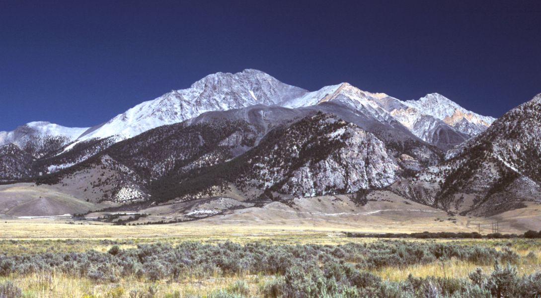
Dimensioni di questa anteprima: 800 × 441 pixel. Altre risoluzioni: 320 × 176 pixel | 640 × 353 pixel.
File originale (1 089 × 600 pixel, dimensione del file: 125 KB, tipo MIME: image/jpeg)
| Questo file e la sua pagina di descrizione (discussione · modifica) si trovano su Wikimedia Commons (?) |
Dettagli
| Descrizione | English: Borah Peak, Idaho, looking east. The normal climbing route begins in the wooded canyon at center left. The white line running along the base of the peak is the fault trace from the 1983 earthquake. |
| Data | 6 maggio 2006 (data di caricamento originaria) |
| Fonte | Trasferito da en.wikipedia su Commons da RedWolf utilizzando CommonsHelper. |
| Autore | G. Thomas di Wikipedia in inglese |
Licenza
| Quest'opera è stata rilasciata nel pubblico dominio dal suo autore, G. Thomas di Wikipedia in inglese. Questa norma si applica in tutto il mondo. In alcuni paesi questo potrebbe non essere legalmente possibile. In tal caso: G. Thomas garantisce a chiunque il diritto di utilizzare quest'opera per qualsiasi scopo, senza alcuna condizione, a meno che tali condizioni siano richieste dalla legge. |
Registro originale del caricamento
La pagina di descrizione originale era qui. Tutti i nomi utente che seguono sono riferiti a en.wikipedia.
- 2006-05-06 20:17 G. Thomas 1089×600× (127941 bytes) Borah Peak, Idaho, looking east. The normal climbing route begins in the wooded canyon at center left. The white line running along the base of the peak is the fault trace from the 1983 earthquake.
Cronologia del file
Fare clic su un gruppo data/ora per vedere il file come si presentava nel momento indicato.
| Data/Ora | Miniatura | Dimensioni | Utente | Commento | |
|---|---|---|---|---|---|
| attuale | 18:15, 21 feb 2009 | | 1 089 × 600 (125 KB) | RedWolf | {{Information |Description={{en|Borah Peak, Idaho, looking east. The normal climbing route begins in the wooded canyon at center left. The white line running along the base of the peak is the fault trace from the 1983 earthquake.}} |Source=Transferred f |
Utilizzo del file
La seguente pagina usa questo file:
Utilizzo globale del file
Anche i seguenti wiki usano questo file:
- Usato nelle seguenti pagine di bg.wikipedia.org:
- Usato nelle seguenti pagine di cs.wikipedia.org:
- Usato nelle seguenti pagine di en.wikipedia.org:
- List of mountains of the United States
- Borah Peak
- List of U.S. states and territories by elevation
- Lost River Range
- List of the most isolated major summits of the United States
- List of ultras of North America
- List of the most prominent summits of the United States
- List of the major 100-kilometer summits of North America
- Mountain states
- List of the highest major summits of North America
- List of the major 3000-meter summits of the Rocky Mountains
- List of the highest major summits of the United States
- Usato nelle seguenti pagine di es.wikipedia.org:
- Usato nelle seguenti pagine di it.wikipedia.org:
- Usato nelle seguenti pagine di nl.wikipedia.org:
- Usato nelle seguenti pagine di pt.wikipedia.org:
- Usato nelle seguenti pagine di ru.wikipedia.org:
- Usato nelle seguenti pagine di simple.wikipedia.org:
- Usato nelle seguenti pagine di uk.wikipedia.org:
Metadati
Explore the world

United states
New York

Japan
Tokyo

Singapore
Singapore
