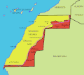
Western_sahara_map_showing_morocco_and_polisaro.gif (626 × 562 פיקסלים, גודל הקובץ: 21 ק"ב, סוג MIME: image/gif)
היסטוריית הקובץ
ניתן ללחוץ על תאריך/שעה כדי לראות את הקובץ כפי שנראה באותו זמן.
| תאריך/שעה | תמונה ממוזערת | ממדים | משתמש | הערה | |
|---|---|---|---|---|---|
| נוכחית | 23:41, 15 במרץ 2011 |  | 562 × 626 (21 ק"ב) | Omar-Toons | neutral version |
| 03:47, 3 בנובמבר 2005 |  | 562 × 626 (20 ק"ב) | Roke~commonswiki | ||
| 03:45, 3 בנובמבר 2005 |  | 562 × 626 (20 ק"ב) | Roke~commonswiki | Map shows Moroccan (yellow) and Polisaro (red) control of Western Sahara. I made the image. Based on [http://www.newint.org/issue374/pics/western-sahara-map-big.jpg]. The purple line is the wall built by Morocco on an alternate map: [http://www.arso.org/S |
שימוש בקובץ
הדף הבא משתמש בקובץ הזה:
שימוש גלובלי בקובץ
אתרי הוויקי האחרים הבאים משתמשים בקובץ הזה:
- שימוש באתר am.wikipedia.org
- שימוש באתר ar.wikipedia.org
- שימוש באתר az.wikipedia.org
- שימוש באתר ca.wikipedia.org
- שימוש באתר ckb.wikipedia.org
- שימוש באתר de.wikipedia.org
- שימוש באתר en.wikipedia.org
- שימוש באתר fa.wikipedia.org
- שימוש באתר fr.wikipedia.org
- שימוש באתר he.wikipedia.org
- שימוש באתר hu.wikipedia.org
- שימוש באתר id.wikipedia.org
- שימוש באתר ka.wikipedia.org
- שימוש באתר ko.wikipedia.org
- שימוש באתר mt.wikipedia.org
- שימוש באתר mzn.wikipedia.org
- שימוש באתר nl.wikipedia.org
- שימוש באתר nn.wikipedia.org
- שימוש באתר pt.wikibooks.org
- שימוש באתר ru.wikipedia.org
- שימוש באתר scn.wikipedia.org
- שימוש באתר uk.wikipedia.org
- שימוש באתר www.wikidata.org


 Français
 Italiano


