
 Français
 Italiano
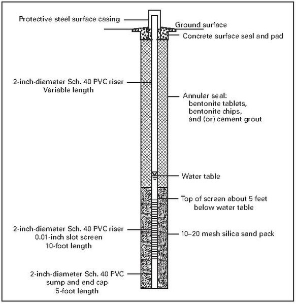
גודל התצוגה המקדימה הזאת מסוג JPG של קובץ ה־PDF הזה: 583 × 599 פיקסלים. רזולוציות אחרות: 233 × 240 פיקסלים | 608 × 625 פיקסלים.
לקובץ המקורי (608 × 625 פיקסלים, גודל הקובץ: 182 ק"ב, סוג MIME: application/pdf)
זהו קובץ שמקורו במיזם ויקישיתוף. תיאורו בדף תיאור הקובץ המקורי (בעברית) מוצג למטה ויקישיתוף הוא מאגר תמונות וקובצי מדיה חופשיים. אתם יכולים לעזור. |
תקציר
| תיאור | English: Schematic diagram of a groundwater monitoring well |
| תאריך יצירה | |
| מקור | https://pubs.usgs.gov/publication/ds456 Arnold, L.R., Flynn, J.L., and Paschke, S.S., 2009, Design and installation of a groundwater monitoring-well network in the High Plains aquifer, Colorado: U.S. Geological Survey Data Series 456, 47 p. Figure 8. Schematic diagram of High Plains groundwater monitoring-well completions. |
| יוצר | Arnold, L.R., Flynn, J.L., and Paschke, S.S. |
רישיון
This work is in the public domain in the United States because it is a work prepared by an officer or employee of the United States Government as part of that person’s official duties under the terms of Title 17, Chapter 1, Section 105 of the US Code. Note: This only applies to original works of the Federal Government and not to the work of any individual U.S. state, territory, commonwealth, county, municipality, or any other subdivision. This template also does not apply to postage stamp designs published by the United States Postal Service since 1978. (See § 313.6(C)(1) of Compendium of U.S. Copyright Office Practices). It also does not apply to certain US coins; see The US Mint Terms of Use. |  | |
| הקובץ הזה זוהה כקובץ חופשי מכל מגבלה ידועה תחת חוק זכויות היוצרים, כולל כל הזכויות הקשורות והסמוכות. | ||
היסטוריית הקובץ
ניתן ללחוץ על תאריך/שעה כדי לראות את הקובץ כפי שנראה באותו זמן.
| תאריך/שעה | תמונה ממוזערת | ממדים | משתמש | הערה | |
|---|---|---|---|---|---|
| נוכחית | 18:53, 27 במאי 2024 |  | 625 × 608 (182 ק"ב) | Justaxn | Uploaded a work by Arnold, L.R., Flynn, J.L., and Paschke, S.S. from https://pubs.usgs.gov/publication/ds456 Arnold, L.R., Flynn, J.L., and Paschke, S.S., 2009, Design and installation of a groundwater monitoring-well network in the High Plains aquifer, Colorado: U.S. Geological Survey Data Series 456, 47 p. Figure 8. Schematic diagram of High Plains groundwater monitoring-well completions. with UploadWizard |
שימוש בקובץ
אין דפים המשתמשים בקובץ זה.
שימוש גלובלי בקובץ
אתרי הוויקי האחרים הבאים משתמשים בקובץ הזה:
- שימוש באתר en.wikipedia.org
מטא־נתונים
Explore the world

United states
New York

Japan
Tokyo

Singapore
Singapore
