
 Français
 Italiano
גודל התצוגה המקדימה הזאת מסוג PNG של קובץ ה־SVG הזה: 529 × 395 פיקסלים. רזולוציות אחרות: 320 × 239 פיקסלים | 640 × 478 פיקסלים | 1,024 × 765 פיקסלים | 1,280 × 956 פיקסלים | 2,560 × 1,912 פיקסלים.
לקובץ המקורי (קובץ SVG, הגודל המקורי: 529 × 395 פיקסלים, גודל הקובץ: 107 ק"ב)
זהו קובץ שמקורו במיזם ויקישיתוף. תיאורו בדף תיאור הקובץ המקורי (בעברית) מוצג למטה ויקישיתוף הוא מאגר תמונות וקובצי מדיה חופשיים. אתם יכולים לעזור. |
תקציר
| תיאור | |
| תאריך יצירה | |
| מקור | נוצר על־ידי מעלה היצירה . Adobe Illustrator עם נוצרה ה תמונה |
| יוצר | Kjmoran |
| גרסאות אחרות |

רישיון
| היצירה הזאת שוחררה לנחלת הכלל על־ידי היוצר שלה, Kjmoran מוויקיפדיה האנגלית. זה תקף בכל העולם. יש מדינות שבהן הדבר אינו אפשרי על פי חוק, אם כך: Kjmoran מעניק לכל אחד את הזכות להשתמש ביצירה הזאת לכל מטרה, ללא שום תנאי, אלא אם כן תנאים כאלה נדרשים לפי החוק. |
יומן העלאה מקורי
תיאור הקובץ המקורי נמצא כאן. כל שמות המשתמשים הבאים מתייחסים ל-en.wikipedia.
| תאריך/שעה | ממדים | משתמש | הערה |
|---|---|---|---|
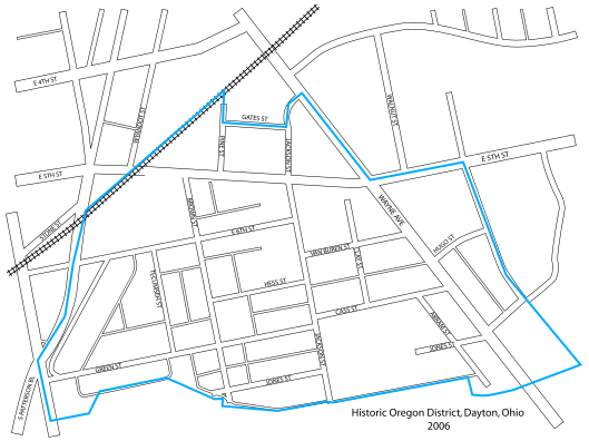
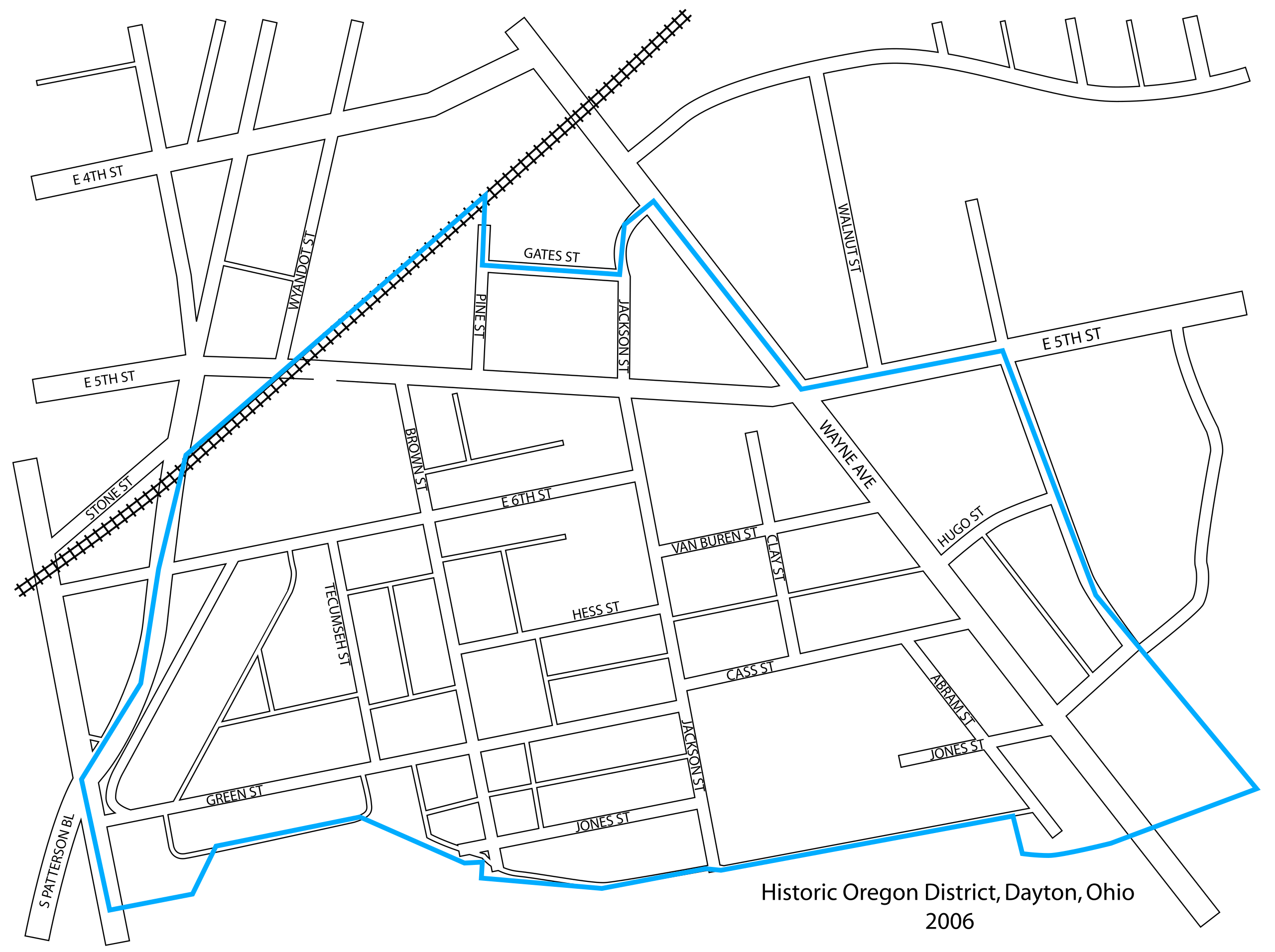
| 2007-01-23 15:32 | 529×395× (109273 bytes) | Kjmoran | == Licensing == {{PD-self}} {{Information| |Description= 2006 map of the [[Oregon District, Dayton, Ohio|Oregon Historic District]] in [[Dayton, Ohio]] |Source=I created this map using [[Adobe Illustrator]]. |Date= 21 December 2006 |Author= [[user:Kjmora |
| 2007-01-23 15:22 | 529×395× (99359 bytes) | Kjmoran | == Licensing == {{PD-self}} {{Information| |Description= 2006 map of the [[Oregon District, Dayton, Ohio|Oregon Historic District]] in [[Dayton, Ohio]] |Source=I created this map using [[Adobe Illustrator]]. |Date= 21 December 2006 |Author= [[user:Kjmora (version lost by MediaWiki) |
| 2007-01-23 15:20 | 529×395× (99359 bytes) | Kjmoran | == Licensing == {{PD-self}} {{Information| |Description= 2006 map of the [[Oregon District, Dayton, Ohio|Oregon Historic District]] in [[Dayton, Ohio]] |Source=I created this map using [[Adobe Illustrator]]. |Date= 21 December 2006 |Author= [[user:Kjmora (version lost by MediaWiki) |
| 2007-01-23 15:17 | 529×395× (99359 bytes) | Kjmoran | == Licensing == {{PD-self}} {{Information| |Description= 2006 map of the [[Oregon District, Dayton, Ohio|Oregon Historic District]] in [[Dayton, Ohio]] |Source=I created this map using [[Adobe Illustrator]]. |Date= 21 December 2006 |Author= [[user:Kjmora (version lost by MediaWiki) |
| 2006-12-21 17:46 | 529×395× (148624 bytes) | Kjmoran | (version lost by MediaWiki) |
היסטוריית הקובץ
ניתן ללחוץ על תאריך/שעה כדי לראות את הקובץ כפי שנראה באותו זמן.
| תאריך/שעה | תמונה ממוזערת | ממדים | משתמש | הערה | |
|---|---|---|---|---|---|
| נוכחית | 21:54, 10 באוגוסט 2019 | | 395 × 529 (107 ק"ב) | Magog the Ogre | Transferred from en.wikipedia via #commonshelper |
שימוש בקובץ
אין דפים המשתמשים בקובץ זה.
שימוש גלובלי בקובץ
אתרי הוויקי האחרים הבאים משתמשים בקובץ הזה:
- שימוש באתר en.wikipedia.org
מטא־נתונים
Explore the world

United states
New York

Japan
Tokyo

Singapore
Singapore
