
 Français
 Italiano
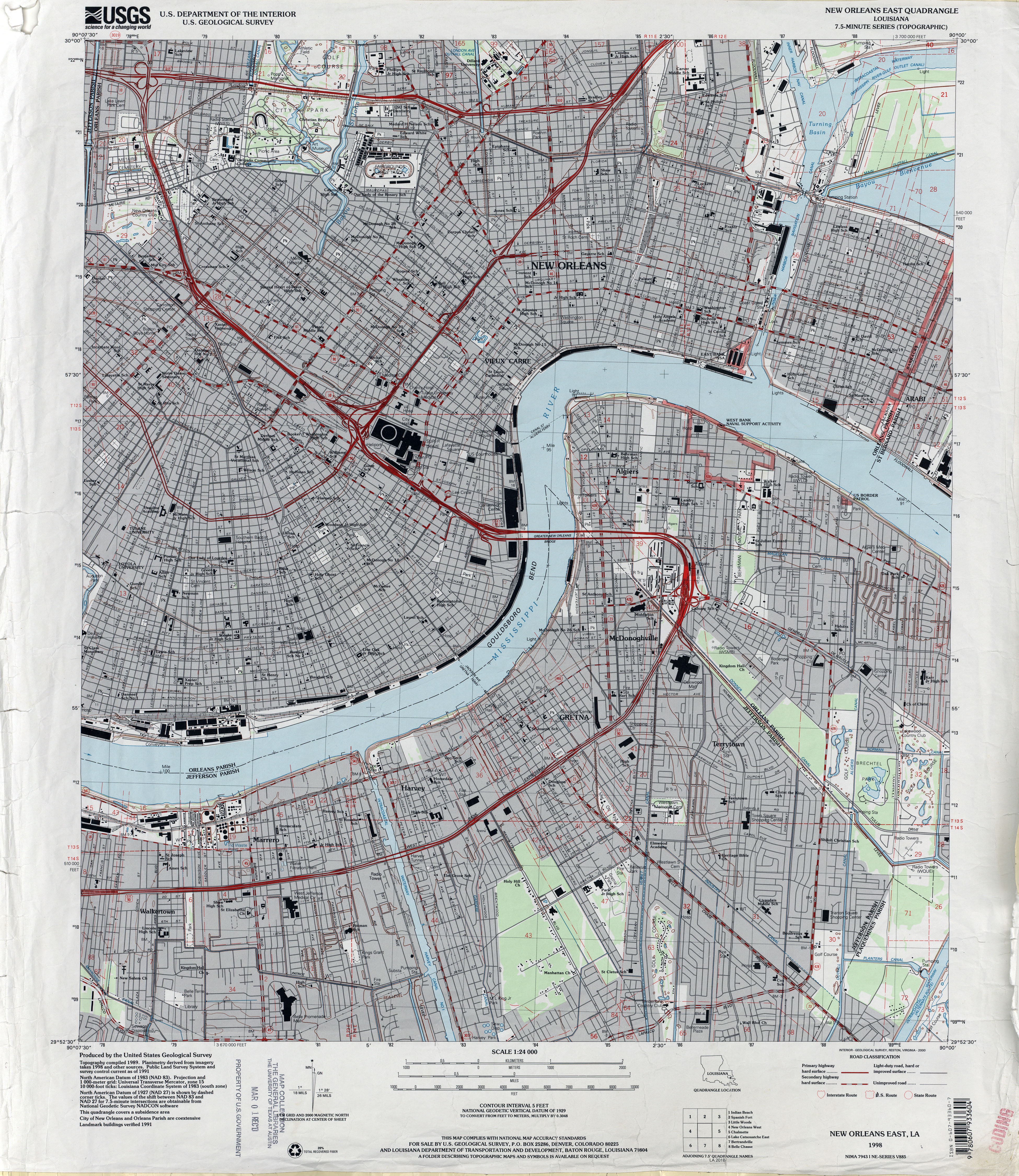
גודל התצוגה המקדימה הזאת: 519 × 599 פיקסלים. רזולוציות אחרות: 208 × 240 פיקסלים | 416 × 480 פיקסלים | 665 × 768 פיקסלים | 887 × 1,024 פיקסלים | 1,774 × 2,048 פיקסלים | 3,899 × 4,500 פיקסלים.
לקובץ המקורי (3,899 × 4,500 פיקסלים, גודל הקובץ: 4.88 מ"ב, סוג MIME: image/jpeg)
זהו קובץ שמקורו במיזם ויקישיתוף. תיאורו בדף תיאור הקובץ המקורי (בעברית) מוצג למטה ויקישיתוף הוא מאגר תמונות וקובצי מדיה חופשיים. אתם יכולים לעזור. |
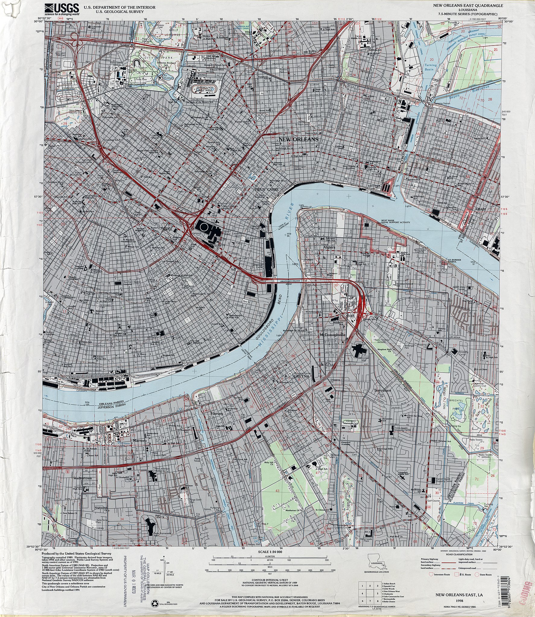
| תיאור | 1998 map of New Orleans, showing the section of the city closer to the Mississippi River, from about Mid-City to just below Audubon Park to the Lower 9th Ward, together with Algiers and the West Bank Jefferson Parish suburbs including Marrero, Harvey, Gretna. | |||
| תאריך יצירה | ||||
| מקור | U.S. Geological Survey map, 1998, via [1] | |||
| יוצר | U.S. Geological Survey | |||
| אישורים והיתרים (שימוש חוזר בקובץ זה) |
|
היסטוריית הקובץ
ניתן ללחוץ על תאריך/שעה כדי לראות את הקובץ כפי שנראה באותו זמן.
| תאריך/שעה | תמונה ממוזערת | ממדים | משתמש | הערה | |
|---|---|---|---|---|---|
| נוכחית | 01:52, 20 ביוני 2012 | | 4,500 × 3,899 (4.88 מ"ב) | Infrogmation | {{Information |Description= 1998 map of New Orleans, showing the section of the city closer to the Mississippi River, from about Mid-City to just below Audubon Park to the Lower 9th Ward, together with Algiers and the West Bank Jefferson Parish suburbs... |
שימוש בקובץ
אין דפים המשתמשים בקובץ זה.
שימוש גלובלי בקובץ
אתרי הוויקי האחרים הבאים משתמשים בקובץ הזה:
- שימוש באתר en.wikipedia.org
- Gretna, Louisiana
- Harvey, Louisiana
- Marrero, Louisiana
- Metairie Cemetery
- New Orleans Mint
- Confederate Memorial Hall Museum
- New Orleans Jazz National Historical Park
- Lafitte's Blacksmith Shop
- New Orleans Cotton Exchange
- Longue Vue House and Gardens
- Algiers Point
- Pitot House
- Congo Square
- Jackson Square (New Orleans)
- Perseverance Hall
- Saenger Theatre (New Orleans)
- Gallier Hall
- National American Bank Building
- Orpheum Theater (New Orleans)
- The Presbytere
- St. Patrick's Church (New Orleans, Louisiana)
- Napoleon House
- George Washington Cable House
- St. Alphonsus Church, New Orleans
- Gallier House
- Hermann–Grima House
- Louisiana State Bank Building
- Madame John's Legacy
- Pontalba Buildings
- St. Mary's Assumption Church (New Orleans, Louisiana)
- Old Ursuline Convent, New Orleans
- Jackson Barracks
- Vieux Carre Property Owners, Residents and Associates
- St. Vincent De Paul Roman Catholic Church (New Orleans, Louisiana)
- Robert E. Lee Monument (New Orleans)
- Blue Plate Building
- Huey P. Long Mansion
- United States Custom House (New Orleans)
- John Minor Wisdom United States Court of Appeals Building
- Aldrich–Genella House
- American Chicle Company Building
- Arabella Station
- Bank of Louisiana
- General Beauregard Equestrian Statue
- Odd Fellows Rest Cemetery
- Union Bethel A.M.E. Church (New Orleans, Louisiana)
- St. Peter A.M.E. Church
- St. James AME Church (New Orleans, Louisiana)
- U.S. Army Supply Base New Orleans
- Module:Location map/data/United States New Orleans East
צפייה בשימושים גלובליים נוספים של הקובץ הזה.
מטא־נתונים
Explore the world

United states
New York

Japan
Tokyo

Singapore
Singapore
