
 Français
 Italiano
גודל התצוגה המקדימה הזאת מסוג PNG של קובץ ה־SVG הזה: 761 × 599 פיקסלים. רזולוציות אחרות: 305 × 240 פיקסלים | 610 × 480 פיקסלים | 975 × 768 פיקסלים | 1,280 × 1,008 פיקסלים | 2,560 × 2,016 פיקסלים | 796 × 627 פיקסלים.
לקובץ המקורי (קובץ SVG, הגודל המקורי: 796 × 627 פיקסלים, גודל הקובץ: 1.89 מ"ב)
זהו קובץ שמקורו במיזם ויקישיתוף. תיאורו בדף תיאור הקובץ המקורי (בעברית) מוצג למטה ויקישיתוף הוא מאגר תמונות וקובצי מדיה חופשיים. אתם יכולים לעזור. |
תקציר
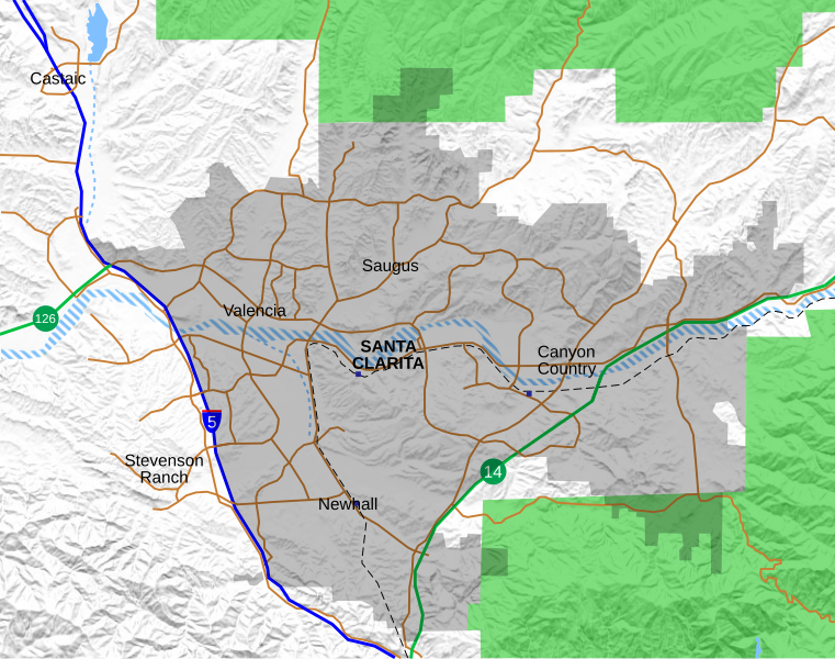
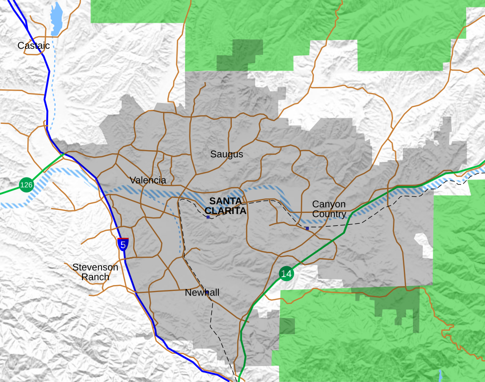
| תיאור | English: Location map for the Santa Clarita Valley in southern California. The scope of the map includes the entire city of Santa Clarita, as well as the nearby unincorporated communities of Stevenson Ranch and part of Castaic. The city limits are as of 2020, and do not include the Tesoro del Valle neighborhood which was annexed into the city in 2022.
Legend: Interstate 5 California State Routes (14 and 126) Major surface streets Metrolink rail line Metrolink station (blue boxes) Santa Clarita city limit (as of 2021) Permanent bodies of water Intermittent bodies of water (Santa Clara River and tributaries) Angeles National Forest |
| תאריך יצירה | |
| מקור | נוצר על־ידי מעלה היצירה, with data from OpenStreetMap. Shaded relief derived from USGS. |
| יוצר | Crossover1370 |
רישיון
אני, בעל זכויות היוצרים על עבודה זו, מפרסם בזאת את העבודה תחת הרישיון הבא:
הקובץ הזה מתפרסם לפי תנאי רישיון קריאייטיב קומונז ייחוס-שיתוף זהה 4.0 בין־לאומי.
- יש לך חופש:
- לשתף – להעתיק, להפיץ ולהעביר את העבודה
- לערבב בין עבודות – להתאים את העבודה
- תחת התנאים הבאים:
- ייחוס – יש לתת ייחוס הולם, לתת קישור לרישיון, ולציין אם נעשו שינויים. אפשר לעשות את זה בכל צורה סבירה, אבל לא בשום צורה שמשתמע ממנה שמעניק הרישיון תומך בך או בשימוש שלך.
- שיתוף זהה – יצירת רמיקס, שינוי או בנייה על סמך החומר הזה, תטיל עליך חובה להפיץ את התרומות שלך לפי תנאי רישיון זהה או תואם למקור.
היסטוריית הקובץ
ניתן ללחוץ על תאריך/שעה כדי לראות את הקובץ כפי שנראה באותו זמן.
| תאריך/שעה | תמונה ממוזערת | ממדים | משתמש | הערה | |
|---|---|---|---|---|---|
| נוכחית | 00:05, 25 בספטמבר 2021 | | 627 × 796 (1.89 מ"ב) | Crossover1370 | Remove the relatively minor Canyon Park Blvd and Lost Canyon Rd, and add Tourney Rd, a major street home to numerous hotels, government, and medical offices. |
| 00:47, 22 בספטמבר 2021 |  | 627 × 796 (1.89 מ"ב) | Crossover1370 | A few minor changes involving 3-D placement of certain roads and railroads | |
| 01:56, 21 בספטמבר 2021 |  | 627 × 796 (1.89 מ"ב) | Crossover1370 | Move the word "Santa Clarita" to top to allow it to be selected like the neighborhood names (no visible difference) | |
| 01:11, 21 בספטמבר 2021 |  | 627 × 796 (1.89 מ"ב) | Crossover1370 | Sand Canyon Road and Newhall Ranch Road both pass above their respective freeways. Also add Metrolink stations. | |
| 04:15, 20 בספטמבר 2021 |  | 627 × 796 (1.89 מ"ב) | Crossover1370 | Correct 3D position of streets relative to I-5, rearrange certain objects | |
| 10:01, 19 בספטמבר 2021 |  | 627 × 796 (1.89 מ"ב) | Crossover1370 | Changed outline of Santa Clarita to shading, add Metrolink train and more streets | |
| 21:31, 26 במרץ 2021 |  | 628 × 797 (1,015 ק"ב) | Crossover1370 | Remove section of Placerita Canyon Road west of Sierra Highway - not a major street. | |
| 04:23, 26 במרץ 2021 |  | 628 × 797 (1,016 ק"ב) | Crossover1370 | Removed some minor streets I added in the previous revision. | |
| 10:11, 25 במרץ 2021 |  | 628 × 797 (1,016 ק"ב) | Crossover1370 | Added more major streets. | |
| 08:10, 23 בדצמבר 2020 |  | 628 × 797 (1,013 ק"ב) | Crossover1370 | Santa Clara River is still a big black blob. Hopefully this will fix it. |
שימוש בקובץ
אין דפים המשתמשים בקובץ זה.
שימוש גלובלי בקובץ
אתרי הוויקי האחרים הבאים משתמשים בקובץ הזה:
- שימוש באתר en.wikipedia.org
- Valencia, Santa Clarita, California
- The Master's University
- Newhall Pass
- Castaic, California
- Six Flags Magic Mountain
- College of the Canyons
- Stevenson Ranch, California
- Newhall, Santa Clarita, California
- Canyon Country, Santa Clarita, California
- Saugus, Santa Clarita, California
- Golden Oak Ranch
- Castaic Junction, California
- Santa Clarita, California
- Mentryville, California
- Rancho San Francisco
- Newhall incident
- Gibbon Conservation Center
- Placerita Canyon State Park
- Valencia, California
- Lyons Station Stagecoach Stop
- Peter J. Pitchess Detention Center
- Dry Canyon Reservoir
- Sand Canyon, Santa Clarita, California
- User:Crossover1370
- Beale's Cut Stagecoach Pass
- Lang Southern Pacific Station
- Pioneer Oil Refinery
- Saugus High School shooting
- Valencia Country Club
- Central Park (Santa Clarita)
- Module:Location map/data/Santa Clarita
- Module:Location map/data/Santa Clarita/doc
- Santa Clarita Woodlands Park
- McBean Regional Transit Center
- William S. Hart Regional Park
- שימוש באתר fy.wikipedia.org
- שימוש באתר si.wikipedia.org
- שימוש באתר sv.wikipedia.org
מטא־נתונים
Explore the world

United states
New York

Japan
Tokyo

Singapore
Singapore
