
 Français
 Italiano
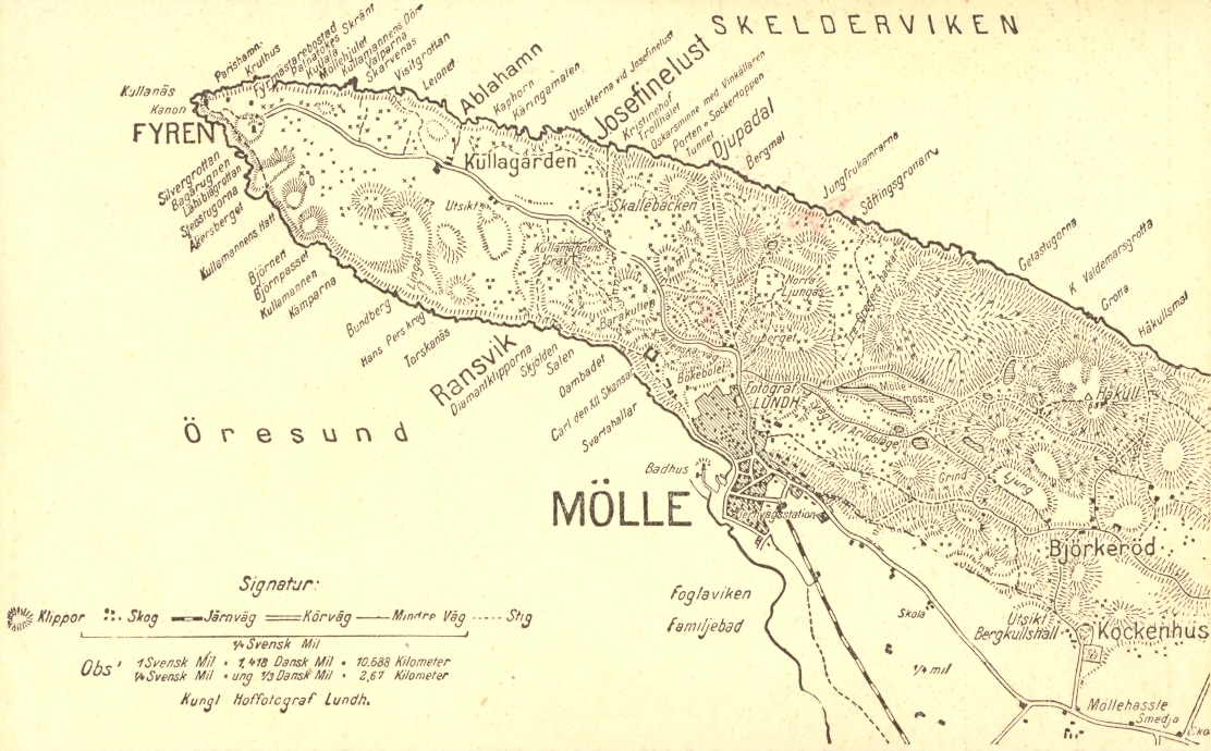
גודל התצוגה המקדימה הזאת: 800 × 496 פיקסלים. רזולוציות אחרות: 320 × 199 פיקסלים | 640 × 397 פיקסלים | 1,112 × 690 פיקסלים.
לקובץ המקורי (1,112 × 690 פיקסלים, גודל הקובץ: 447 ק"ב, סוג MIME: image/jpeg)
זהו קובץ שמקורו במיזם ויקישיתוף. תיאורו בדף תיאור הקובץ המקורי (בעברית) מוצג למטה ויקישיתוף הוא מאגר תמונות וקובצי מדיה חופשיים. אתם יכולים לעזור. |
תקציר
| תיאור | English: Map of Kullaberg, northwestern Skåne County, western Sweden. Svenska: Karta över Kullaberg |
| תאריך יצירה | בסביבות 1910 |
| מקור | Inskannat vykort |
| יוצר | Peter P. Lundh |
רישיון
This Swedish photograph is in the public domain in Sweden because one of the following applies:
For photos in the first category created before 1969, also {{PD-1996}} usually applies. For photos in the second category published before 1930, also {{PD-US-expired}} usually applies. If the photographer died before 1955, {{PD-old-70}} should be used instead of this tag. If the author died before 1926, also {{PD-1996}} usually applies. |  |
היסטוריית הקובץ
ניתן ללחוץ על תאריך/שעה כדי לראות את הקובץ כפי שנראה באותו זמן.
| תאריך/שעה | תמונה ממוזערת | ממדים | משתמש | הערה | |
|---|---|---|---|---|---|
| נוכחית | 23:00, 4 בינואר 2012 | | 690 × 1,112 (447 ק"ב) | Peterappelros | {{Information |Description ={{en|1=Map of Kullaberg, Sweden}} {{sv|1=Karta över Kullaberg}} |Source =Inskannat vykort |Author =Peter P. Lundh |Date =ca 1910 |Permission = |other_versions = }} |
שימוש בקובץ
אין דפים המשתמשים בקובץ זה.
שימוש גלובלי בקובץ
אתרי הוויקי האחרים הבאים משתמשים בקובץ הזה:
- שימוש באתר de.wikipedia.org
- שימוש באתר en.wikipedia.org
- שימוש באתר lt.wikipedia.org
- שימוש באתר nn.wikipedia.org
- שימוש באתר sv.wikipedia.org
- שימוש באתר vi.wikipedia.org
- שימוש באתר www.wikidata.org
מטא־נתונים
Explore the world

United states
New York

Japan
Tokyo

Singapore
Singapore
