
 Français
 Italiano
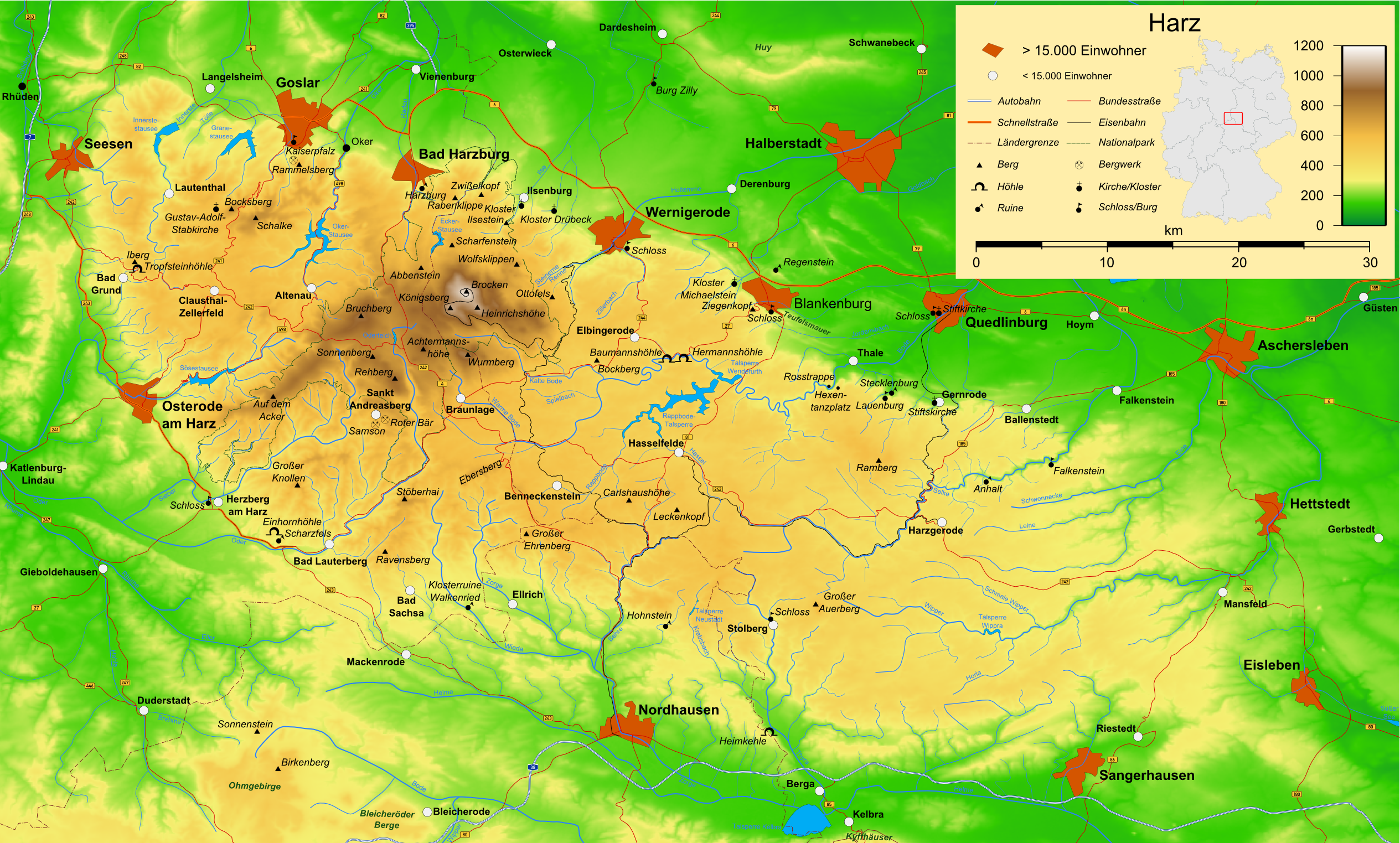
גודל התצוגה המקדימה הזאת: 800 × 482 פיקסלים. רזולוציות אחרות: 320 × 193 פיקסלים | 640 × 385 פיקסלים | 1,024 × 617 פיקסלים | 1,280 × 771 פיקסלים | 2,529 × 1,523 פיקסלים.
לקובץ המקורי (2,529 × 1,523 פיקסלים, גודל הקובץ: 3.15 מ"ב, סוג MIME: image/png)
זהו קובץ שמקורו במיזם ויקישיתוף. תיאורו בדף תיאור הקובץ המקורי (בעברית) מוצג למטה ויקישיתוף הוא מאגר תמונות וקובצי מדיה חופשיים. אתם יכולים לעזור. |
תקציר
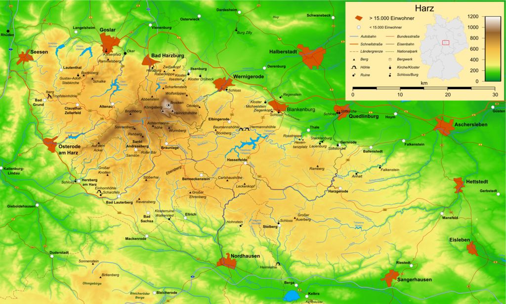
| תיאור | Map of the Harz mountains in Germany with mountains, rivers, lakes, reservoirs, all highways, all Bundesstraßen, Harzquerbahn, Brockenbahn, Selketalbahn, major towns and sights. |
| תאריך יצירה | |
| מקור | נוצר על־ידי מעלה היצירה |
| יוצר | Bamse |
| גרסאות אחרות | Derivative works of this file: Karte Harzer Schmalspurbahnen.png  , ,  , ,  |
The map has been created with the Generic Mapping Tools: https://www.generic-mapping-tools.org/ using one or more of these public-domain datasets for the relief:
|
 | מוענקת בכך הרשות להעתיק, להפיץ או לשנות את המסמך הזה, לפי תנאי הרישיון לשימוש חופשי במסמכים של גנו, גרסה 1.2 או כל גרסה מאוחרת יותר שתפורסם על־ידי המוסד לתוכנה חופשית; ללא פרקים קבועים, ללא טקסט עטיפה קדמית וללא טקסט עטיפה אחורית. עותק של הרישיון כלול בפרק שכותרתו הרישיון לשימוש חופשי במסמכים של גנו. |
| הקובץ הזה מתפרסם לפי תנאי רישיון קריאייטיב קומונז ייחוס-שיתוף זהה 3.0 לא מותאם. | ||
| ||
| תבנית רישוי זו הוספה לקובץ כחלק מעדכון רישיון GFDL. |
 | This map has been made or improved in the German Kartenwerkstatt (Map Lab). You can propose maps to improve as well. |
היסטוריית הקובץ
ניתן ללחוץ על תאריך/שעה כדי לראות את הקובץ כפי שנראה באותו זמן.
| תאריך/שעה | תמונה ממוזערת | ממדים | משתמש | הערה | |
|---|---|---|---|---|---|
| נוכחית | 19:05, 15 בדצמבר 2009 | | 1,523 × 2,529 (3.15 מ"ב) | Bamse | update, B6n is completed |
| 09:12, 14 בדצמבר 2007 |  | 1,523 × 2,529 (3.15 מ"ב) | Bamse | {{Information |Description=Map of the Harz mountains in Germany with mountains, rivers, lakes, reservoirs, all highways, all Bundesstraßen, Harzquerbahn, Brockenbahn, [[:w:Selketalba | |
| 08:10, 19 בספטמבר 2007 |  | 1,523 × 2,529 (3.14 מ"ב) | Bamse | ||
| 05:33, 19 בספטמבר 2007 |  | 1,523 × 2,529 (3.13 מ"ב) | Bamse | {{Information |Description=Map of the w:Harz mountains in Germany. |Source=self-made |Date=19-09-2007 |Author= Bamse }} {{GFDL-GMT}} | |
| 11:21, 5 בספטמבר 2007 |  | 1,523 × 2,529 (3.09 מ"ב) | Bamse | {{Information |Description=Map of the w:Harz mountains in Germany. |Source=self-made |Date=05-09-2007 |Author= Bamse }} {{GFDL-GMT}} | |
| 09:02, 25 ביולי 2007 |  | 1,527 × 2,532 (3 מ"ב) | Bamse | {{Information |Description=Map of the w:Harz mountains in Germany. |Source=self-made |Date=25-07-2007 |Author= Bamse }} {{GFDL-GMT}} | |
| 13:30, 17 ביולי 2007 |  | 1,526 × 2,529 (2.94 מ"ב) | Bamse | {{Information |Description=Map of the w:Harz mountains in Germany. |Source=self-made |Date=17-07-2007 |Author= Bamse }} {{GFDL-GMT}} | |
| 14:42, 11 ביולי 2007 |  | 1,523 × 2,529 (2.89 מ"ב) | Bamse | {{Information |Description=Map of the w:Harz mountains in Germany. |Source=self-made |Date=11-07-2007 |Author= Bamse }} {{GFDL-GMT}} | |
| 13:21, 6 ביולי 2007 |  | 1,523 × 2,529 (2.84 מ"ב) | Bamse | {{Information |Description=Map of the w:Harz mountains in Germany. |Source=self-made |Date=06-07-2007 |Author= Bamse }} {{GFDL-GMT}} | |
| 05:48, 28 ביוני 2007 |  | 1,523 × 2,529 (2.77 מ"ב) | Bamse | {{Information |Description=Map of the w:Harz mountains in Germany. |Source=self-made |Date=28-06-2007 |Author= Bamse }} {{GFDL-GMT}} |
שימוש בקובץ
אין דפים המשתמשים בקובץ זה.
שימוש גלובלי בקובץ
אתרי הוויקי האחרים הבאים משתמשים בקובץ הזה:
- שימוש באתר ar.wikipedia.org
- שימוש באתר be.wikipedia.org
- שימוש באתר bg.wikipedia.org
- שימוש באתר br.wikipedia.org
- שימוש באתר ca.wikipedia.org
- שימוש באתר de.wikipedia.org
- Harz (Mittelgebirge)
- Harzer Hexenstieg
- Kaiserweg (Harz)
- Karstwanderweg
- Wikipedia:Kartenwerkstatt/Archiv/2007-09
- Liste von Bergen im Harz
- Wikipedia:Kandidaten für exzellente Bilder/Archiv2007/14
- Harzklippen
- Selketalstieg
- Benutzer:Ulflulfl/Karten
- Harzer Baudensteig
- Harzer Försterstieg
- Unterharzer Teich- und Grabensystem
- Portal:Harz
- Bode-Selke-Stieg
- Oberharzer Erzgänge
- Vorlage:Navigationsleiste Regionale Wanderwege im Harz
- Harzer Grenzweg
- Liste der Moore im Harz
- Harzer Klosterwanderweg
- Kaiser-Otto-Höhenweg
- Georgi Wladimirowitsch Iwanow
- Steinway Trail
- Teufelsstieg
- Gebietstausch 1945 im Harz
- Portal:Harz/Eingangstext
- Benutzer:D.W.Germann/Liste von Poststempeln im Harz
- Benutzer:D.W.Germann/Liste der Brockenkarten
- Benutzer:D.W.Germann/Eigenes/Mediensammlung
- Benutzer:D.W.Germann/Liste der Kartenwerke des Harzes
- שימוש באתר en.wikipedia.org
- שימוש באתר eo.wikipedia.org
- שימוש באתר fi.wikipedia.org
- שימוש באתר fr.wikipedia.org
- שימוש באתר fr.wiktionary.org
- שימוש באתר hu.wikipedia.org
- שימוש באתר incubator.wikimedia.org
- שימוש באתר is.wikipedia.org
- שימוש באתר it.wikipedia.org
צפייה בשימושים גלובליים נוספים של הקובץ הזה.
Explore the world

United states
New York

Japan
Tokyo

Singapore
Singapore
