לקובץ המקורי (1,538 × 1,484 פיקסלים, גודל הקובץ: 568 ק"ב, סוג MIME‏: image/jpeg)

זהו קובץ שמקורו במיזם ויקישיתוף. תיאורו בדף תיאור הקובץ המקורי (בעברית) מוצג למטה
ויקישיתוף הוא מאגר תמונות וקובצי מדיה חופשיים. אתם יכולים לעזור.

תקציר

Corke   (Wikidata search (Cirrus search) Wikidata query (SPARQL)  Create new Wikidata item based on this file)
יוצר
הרמן מול (1654–1732)  wikidata:Q1610319
 
הרמן מול
שמות חלופיים
Moll, Hermann
תיאור cartographer, engraver ומוֹצִיא לָאוֹר בריטי
תאריך לידה/פטירה בסביבות 1654
date QS:P,+1654-00-00T00:00:00Z/9,P1480,Q5727902
‏22 בספטמבר 1732‏ לערוך בוויקינתונים
מיקום לידה/פטירה לא ידועUnknown place לונדון לערוך בוויקינתונים
פעל ב
קובץ זהויות
creator QS:P170,Q1610319
כותרת
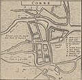
Corke
תיאור
English: A detail map of Cork c. 1714 from Moll's "A New Map of Ireland Divided into Its Provinces, Counties and Baronies...", sold separately or as part of The World Described as p. 19.


Notes: Printed for H. Moll over against Devereux Court in ye Strand, I. Bowles at the Black Horse in Cornhill, P. Overton Map & Printseller near St. Dunstans Church Fleetstreet, and T. Bowles Print & Mapseller next to the Chapter house in St. Pauls Church Yard. And by I. King Map and Printseller at the Globe in the Poultry.
תאריך יצירה 1714
date QS:P571,+1714-00-00T00:00:00Z/9
ממדים Original Map:
גובה: 64 ס"מ; רוחב: 105 ס"מ
dimensions QS:P2048,64U174728
dimensions QS:P2049,105U174728
institution QS:P195,Q193563
סימוכין
Français : Notice de recueil : http://catalogue.bnf.fr/ark:/12148/cb40577015h

Appartient à : Collection d'Anville ; 02633 B

Notice du catalogue : http://catalogue.bnf.fr/ark:/12148/cb406183087
מקור/צלם
Français : Bibliothèque nationale de France, département Cartes et plans, GE DD-2987 (2633 B)
Bibliothèque nationale de France
גרסאות אחרות

רישיון

Public domain
This work is in the public domain in the United States because it was published (or registered with the U.S. Copyright Office) before January 1, 1930.

Public domain works must be out of copyright in both the United States and in the source country of the work in order to be hosted on the Commons. If the work is not a U.S. work, the file must have an additional copyright tag indicating the copyright status in the source country.
Note: This tag should not be used for sound recordings.PD-1923Public domain in the United States//commons.wikimedia.org/wiki/File:Corke_1714_(Moll).jpg
Public domain
This work is in the public domain in France for one of the following reasons:
  • Its author (or the last of its authors in the case of a collaboration work) died more than 70 years ago (CPI art. L123-1) and did not benefit from any copyright extension (CPI art. L123-8, L123-9 and L123-10)[1];
  • It is an anonymous or pseudonymous work (the identity of the author has never been disclosed) or a collective work[2] and more than 70 years have passed since its publication (CPI art. L123-3);
  • It is the recording of an audiovisual or musical work already in the public domain, and more than 50 years have passed since the performance or the recording (CPI art. L211-4).

Please note that moral rights still apply when the work is in the public domain. They encompass, among others, the right to the respect of the author's name, quality and work (CPI art. L121-1). Attribution therefore remains mandatory.
  1. Copyright extensions must be considered only in the case of musical works and of authors Mort pour la France (died during conflict, in the service of France). In other cases, they are included in the 70 years post mortem auctoris length (see this statement of the Cour de Cassation).
  2. The collective work status is quite restrictive, please make sure that it is actually established.

العربية  English  español  français  日本語  한국어  македонски  русский  Tiếng Việt  简体中文  繁體中文  +/−

ביאורים
InfoField
תמונה זו מוערת: הצג את ההערות בויקישיתוף

כיתובים

נא להוסיף משפט שמסביר מה הקובץ מייצג

פריטים שמוצגים בקובץ הזה

מוצג

image/jpeg

checksum אנגלית

ef9e34892b453f750eefcb7015a39336b52bd99d

581,137 בית

1,484 פיקסל

1,538 פיקסל

היסטוריית הקובץ

ניתן ללחוץ על תאריך/שעה כדי לראות את הקובץ כפי שנראה באותו זמן.

תאריך/שעהתמונה ממוזערתממדיםמשתמשהערה
נוכחית19:04, 21 במאי 2023תמונה ממוזערת לגרסה מ־19:04, 21 במאי 2023‪1,484 × 1,538‬ (568 ק"ב)LlywelynIIFile:A New Map of Ireland Divided into its Provinces, Counties and Baronies, wherein are distinguished the Bishopricks, Borroughs, Barracks, Bogs, Passes, Bridges, &c. with the Principal Roads, and the common Reputed... - btv1b53057272q.jpg cropped using CropTool.

אין דפים המשתמשים בקובץ זה.

שימוש גלובלי בקובץ

אתרי הוויקי האחרים הבאים משתמשים בקובץ הזה: