
 Français
 Italiano
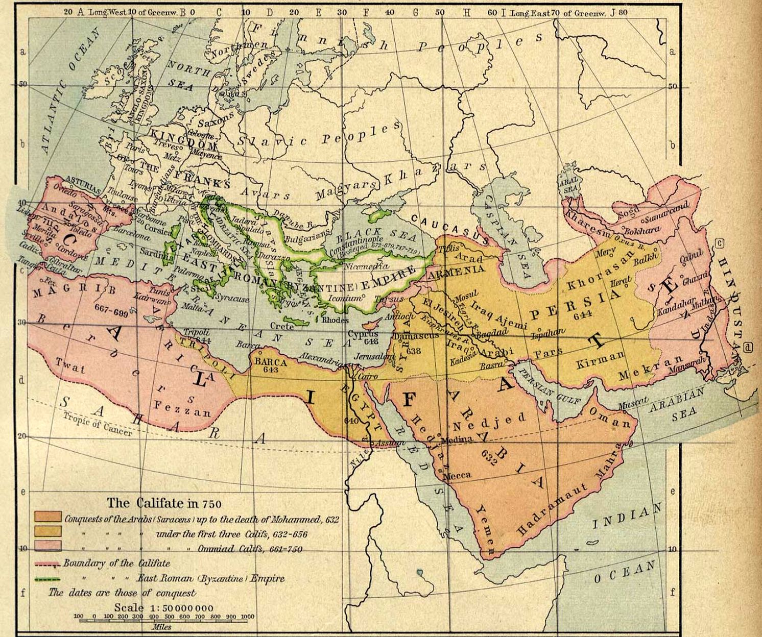
גודל התצוגה המקדימה הזאת: 717 × 600 פיקסלים. רזולוציות אחרות: 287 × 240 פיקסלים | 574 × 480 פיקסלים | 918 × 768 פיקסלים | 1,224 × 1,024 פיקסלים | 1,492 × 1,248 פיקסלים.
לקובץ המקורי (1,492 × 1,248 פיקסלים, גודל הקובץ: 494 ק"ב, סוג MIME: image/jpeg)
זהו קובץ שמקורו במיזם ויקישיתוף. תיאורו בדף תיאור הקובץ המקורי (בעברית) מוצג למטה ויקישיתוף הוא מאגר תמונות וקובצי מדיה חופשיים. אתם יכולים לעזור. |
תקציר
| תיאור | Español: El territorio del Califato en el año 750 English: Map of the Umayyad Caliphate — in 750 CE. |
| תאריך יצירה | |
| מקור |
|
| יוצר | William R. Shepherd |
| גרסאות אחרות | []
|


רישיון
This work is in the public domain in the United States because it was published (or registered with the U.S. Copyright Office) before January 1, 1930. Public domain works must be out of copyright in both the United States and in the source country of the work in order to be hosted on the Commons. If the work is not a U.S. work, the file must have an additional copyright tag indicating the copyright status in the source country. Note: This tag should not be used for sound recordings. |
היסטוריית הקובץ
ניתן ללחוץ על תאריך/שעה כדי לראות את הקובץ כפי שנראה באותו זמן.
| תאריך/שעה | תמונה ממוזערת | ממדים | משתמש | הערה | |
|---|---|---|---|---|---|
| נוכחית | 23:25, 14 בדצמבר 2013 | | 1,248 × 1,492 (494 ק"ב) | Gwillhickers | enlarged image, rendered for brightness and clarity |
| 12:15, 20 באפריל 2005 |  | 1,028 × 1,229 (293 ק"ב) | Ben~commonswiki | Middle East and Europe - The Caliphate in 750 (293K) "The Califate in 750." From The Historical Atlas by William R. Shepherd, 1926. taken from http://www.lib.utexas.edu/maps/historical/history_middle_east.html Courtesy of The General Libraries, The Unive |
שימוש בקובץ
אין דפים המשתמשים בקובץ זה.
שימוש גלובלי בקובץ
אתרי הוויקי האחרים הבאים משתמשים בקובץ הזה:
- שימוש באתר ar.wikipedia.org
- שימוש באתר arz.wikipedia.org
- שימוש באתר ast.wikipedia.org
- שימוש באתר azb.wikipedia.org
- שימוש באתר az.wikipedia.org
- שימוש באתר ba.wikipedia.org
- שימוש באתר be.wikipedia.org
- שימוש באתר bg.wikipedia.org
- שימוש באתר bn.wikipedia.org
- שימוש באתר bs.wikipedia.org
- שימוש באתר ca.wikipedia.org
- שימוש באתר ce.wikipedia.org
- שימוש באתר cs.wikipedia.org
- שימוש באתר da.wikipedia.org
- שימוש באתר de.wikipedia.org
- שימוש באתר en.wikipedia.org
- שימוש באתר eo.wikipedia.org
- שימוש באתר es.wikipedia.org
- שימוש באתר et.wikipedia.org
- שימוש באתר fi.wikipedia.org
- שימוש באתר fr.wikipedia.org
- שימוש באתר gl.wikipedia.org
- שימוש באתר ha.wikipedia.org
- שימוש באתר hr.wikipedia.org
- שימוש באתר hy.wikipedia.org
- שימוש באתר id.wikipedia.org
- שימוש באתר it.wikipedia.org
צפייה בשימושים גלובליים נוספים של הקובץ הזה.
מטא־נתונים
Explore the world

United states
New York

Japan
Tokyo

Singapore
Singapore
