
 Français
 Italiano
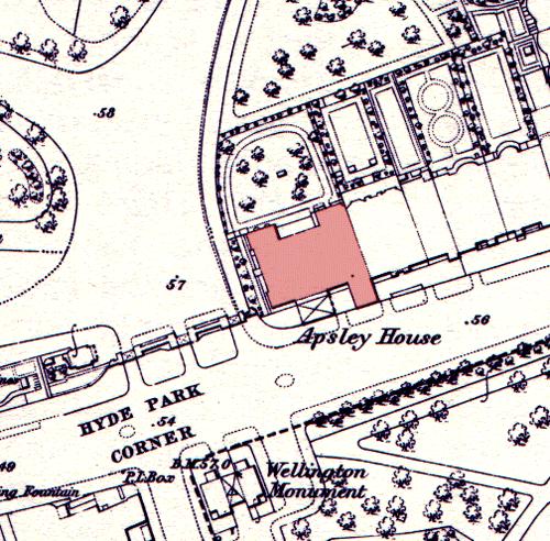
אין גרסה ברזולוציה גבוהה יותר.
Apsley_house_on_an_1869_Ordnance_Survey_Map.JPG (500 × 492 פיקסלים, גודל הקובץ: 79 ק"ב, סוג MIME: image/jpeg)
זהו קובץ שמקורו במיזם ויקישיתוף. תיאורו בדף תיאור הקובץ המקורי (בעברית) מוצג למטה ויקישיתוף הוא מאגר תמונות וקובצי מדיה חופשיים. אתם יכולים לעזור. |
| תיאור | English: Apsley House on an 1869 Ordnance Survey map, showing its position at the end of a terrace. The neighbouring houses were demolished in the post World War II period to allow Park Lane to be straightened and widened. The Wellington Monument has been moved since this time. |
| תאריך יצירה | 15 במאי 2005 (תאריך העלאה מקורי) |
| מקור | הועבר מ- en.wikipedia לוויקישיתוףעל ידי Oxyman באמצעות CommonsHelper. |
| יוצר | מעלה היצירה המקורי היה Oliver Chettle מוויקיפדיה האנגלית |
רישיון
This work is an Ordnance Survey map over 50 years old, which is covered by Crown Copyright which in this case expires 50 years after publication. Ordnance Survey does however ask that they be credited and that the date of publication be given. Any ancillary rights gained through the creation of the electronic version are granted as freely usable under any circumstances. |
This work created by the United Kingdom Government is in the public domain. This is because it is one of the following:
HMSO has declared that the expiry of Crown Copyrights applies worldwide (ref: HMSO Email Reply)
|  |
יומן העלאה מקורי
תיאור הקובץ המקורי נמצא כאן. כל שמות המשתמשים הבאים מתייחסים ל-en.wikipedia.
- 2005-05-15 08:53 Oliver Chettle 500×492× (80749 bytes) Apsley House on an 1869 [[Ordnance Survey]] map, showing its position at the end of a terrace. The neighbouring houses were demolished in the post [[World War II]] period to allow [[Park Lane]] to be widened. The [[Wellington Monument]] has been moved sin
היסטוריית הקובץ
ניתן ללחוץ על תאריך/שעה כדי לראות את הקובץ כפי שנראה באותו זמן.
| תאריך/שעה | תמונה ממוזערת | ממדים | משתמש | הערה | |
|---|---|---|---|---|---|
| נוכחית | 02:23, 6 באוקטובר 2009 | | 492 × 500 (79 ק"ב) | File Upload Bot (Magnus Manske) | {{BotMoveToCommons|en.wikipedia|year={{subst:CURRENTYEAR}}|month={{subst:CURRENTMONTHNAME}}|day={{subst:CURRENTDAY}}}} {{Information |Description={{en|Apsley House on an 1869 en:Ordnance Survey map, showing its position at the end of a terrace. The |
שימוש בקובץ
אין דפים המשתמשים בקובץ זה.
שימוש גלובלי בקובץ
אתרי הוויקי האחרים הבאים משתמשים בקובץ הזה:
- שימוש באתר ar.wikipedia.org
- שימוש באתר en.wikipedia.org
- שימוש באתר es.wikipedia.org
- שימוש באתר fr.wikipedia.org
- שימוש באתר ja.wikipedia.org
- שימוש באתר zh.wikipedia.org
מטא־נתונים
Explore the world

United states
New York

Japan
Tokyo

Singapore
Singapore
