
 Français
 Italiano
גודל התצוגה המקדימה הזאת: 798 × 599 פיקסלים. רזולוציות אחרות: 320 × 240 פיקסלים | 639 × 480 פיקסלים | 1,023 × 768 פיקסלים | 1,280 × 962 פיקסלים | 2,078 × 1,561 פיקסלים.
לקובץ המקורי (2,078 × 1,561 פיקסלים, גודל הקובץ: 467 ק"ב, סוג MIME: image/png)
זהו קובץ שמקורו במיזם ויקישיתוף. תיאורו בדף תיאור הקובץ המקורי (בעברית) מוצג למטה ויקישיתוף הוא מאגר תמונות וקובצי מדיה חופשיים. אתם יכולים לעזור. |
תקציר
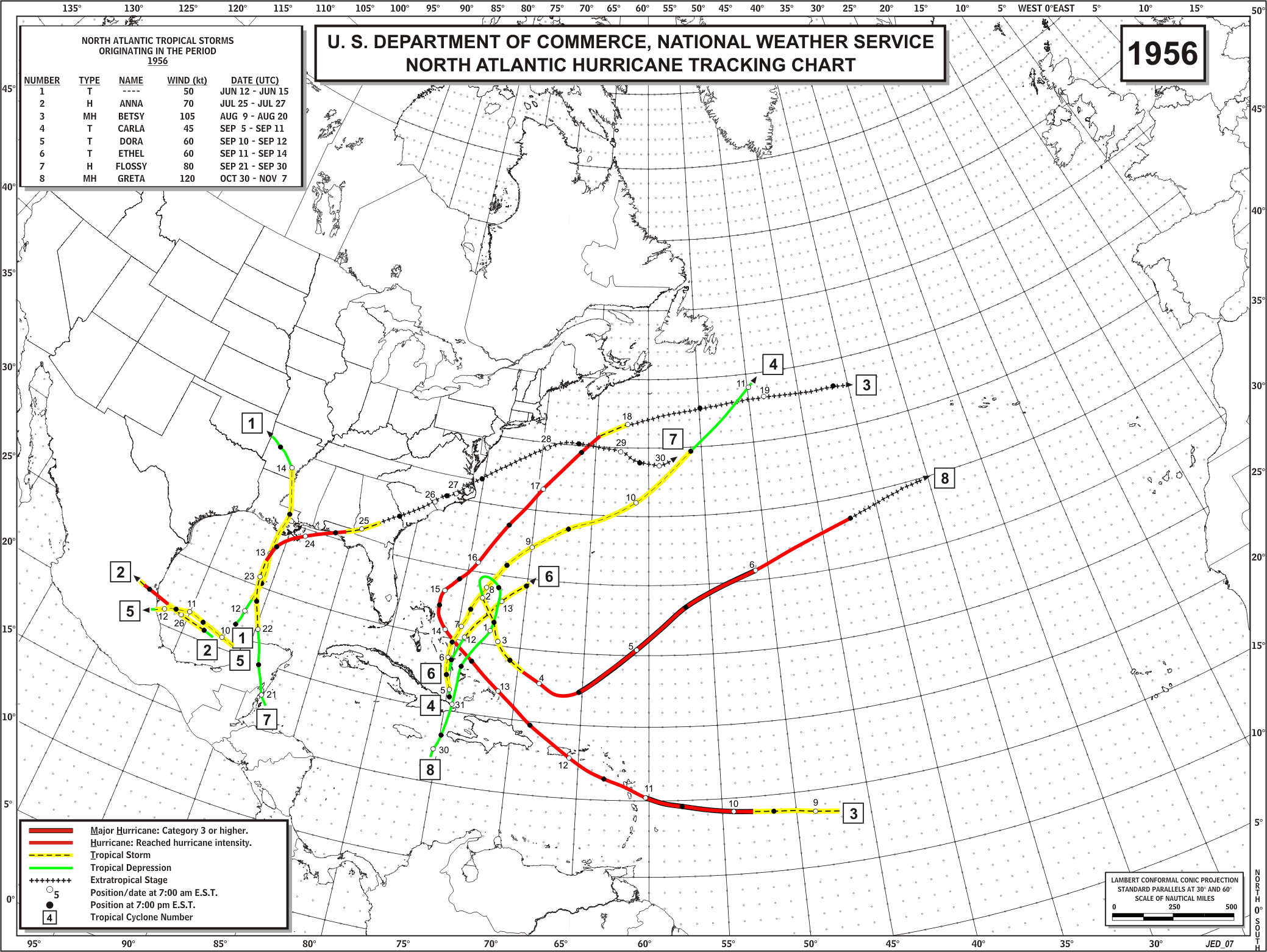
| תיאור | English: Track map of all storms in the 1956 Atlantic hurricane season |
| תאריך יצירה | |
| מקור | http://www.aoml.noaa.gov/hrd/hurdat/track_maps/1956_base.gif |
| יוצר | Hurricane Research Division |
רישיון
This work is in the public domain in the United States because it is a work prepared by an officer or employee of the United States Government as part of that person’s official duties under the terms of Title 17, Chapter 1, Section 105 of the US Code. Note: This only applies to original works of the Federal Government and not to the work of any individual U.S. state, territory, commonwealth, county, municipality, or any other subdivision. This template also does not apply to postage stamp designs published by the United States Postal Service since 1978. (See § 313.6(C)(1) of Compendium of U.S. Copyright Office Practices). It also does not apply to certain US coins; see The US Mint Terms of Use. |  | |
| הקובץ הזה זוהה כקובץ חופשי מכל מגבלה ידועה תחת חוק זכויות היוצרים, כולל כל הזכויות הקשורות והסמוכות. | ||
יומן העלאה מקורי
| תאריך/שעה | ממדים | משתמש | הערה |
|---|---|---|---|
| 23 בדצמבר 2011, 16:47:19 | 2078 × 1561 (452763 bytes) | Hurricanehink (שיחה · תרומות) |
היסטוריית הקובץ
ניתן ללחוץ על תאריך/שעה כדי לראות את הקובץ כפי שנראה באותו זמן.
| תאריך/שעה | תמונה ממוזערת | ממדים | משתמש | הערה | |
|---|---|---|---|---|---|
| נוכחית | 23:18, 19 ביולי 2014 | | 1,561 × 2,078 (467 ק"ב) | GifTagger | Bot: Converting file to superior PNG file. (Source: 1956_Atlantic_hurricane_season_map.gif). This GIF was problematic due to non-greyscale color table. |
שימוש בקובץ
אין דפים המשתמשים בקובץ זה.
שימוש גלובלי בקובץ
אתרי הוויקי האחרים הבאים משתמשים בקובץ הזה:
- שימוש באתר en.wikipedia.org
Explore the world

United states
New York

Japan
Tokyo

Singapore
Singapore
