
 Français
 Italiano
גודל התצוגה המקדימה הזאת: 606 × 600 פיקסלים. רזולוציות אחרות: 242 × 240 פיקסלים | 485 × 480 פיקסלים | 776 × 768 פיקסלים | 1,034 × 1,024 פיקסלים | 2,069 × 2,048 פיקסלים | 5,275 × 5,222 פיקסלים.
לקובץ המקורי (5,275 × 5,222 פיקסלים, גודל הקובץ: 13.27 מ"ב, סוג MIME: image/jpeg)
זהו קובץ שמקורו במיזם ויקישיתוף. תיאורו בדף תיאור הקובץ המקורי (בעברית) מוצג למטה ויקישיתוף הוא מאגר תמונות וקובצי מדיה חופשיים. אתם יכולים לעזור. |
תקציר
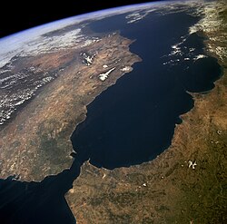
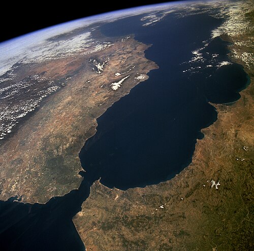
| תיאור | Español: Estrecho de Gibraltar y Mar de Alborán English: The Strait of Gibraltar provides a natural physical barrier between the countries of Spain (north) and Morocco (south). In geologic terms, the 10-mile (16-kilometer) strait that separates the two countries, as well as Europe and Africa, is located where the two major tectonic plates—the Eurasian Plate and the African Plate—collide. This high-oblique, northeast-looking photograph shows the mountainous northern coast of Morocco and the coastal mountains of southern Spain, including the dagger-shaped, snow-covered Sierra Nevada Mountains of southeastern Spain. The Guadalquivir River flows from east to west along the base of the Sierra Morena Mountains in southern Spain. The famous British city of Gibraltar is located on the wedge-shaped peninsula on the east side of the bay in the southernmost protrusion of Spain. The city of Ceuta is a Spanish enclave on the extreme northeastern coast of Morocco. Ceuta, a free port with a large harbor, has remained under Spanish control since 1580. Norsk nynorsk: Satelittfoto frå NASA med Den iberiske halvøya til venstre (nord) og Maghreb til høgre (sør). Vi ser Middelhavet i bakgrunnen og Atlanterhavet nedst til venstre i forgrunnen. Innsnevringa mellom Atlanterhavet og Middelhavet er Gibraltarsundet. |
| תאריך יצירה | |
| מקור | http://images.jsc.nasa.gov/luceneweb/caption_direct.jsp?photoId=STS059-238-074 https://www.flickr.com/photos/nasa2explore/9364207155/ |
| יוצר | NASA |
This image or video was catalogued by one of the centers of the United States National Aeronautics and Space Administration (NASA) under Photo ID: STS059-238-074. This tag does not indicate the copyright status of the attached work. A normal copyright tag is still required. See Commons:Licensing. Other languages:
|
רישיון
| קובץ זה נמצא ברשות הציבור מכיוון שהוא נוצר על ידי נאס"א. מדיניות זכויות היוצרים של נאס"א קובעת ש"חומרים של NASA אינם מוגנים בזכויות יוצרים אלא אם צוין אחרת". (דף מדיניות זכויות היוצרים ב-NASA או מדיניות שימוש בתמונות ב-JPL). | ||
 | אזהרות:
|
| ביאורים | תמונה זו מוערת: הצג את ההערות בויקישיתוף |
היסטוריית הקובץ
ניתן ללחוץ על תאריך/שעה כדי לראות את הקובץ כפי שנראה באותו זמן.
| תאריך/שעה | תמונה ממוזערת | ממדים | משתמש | הערה | |
|---|---|---|---|---|---|
| נוכחית | 14:42, 31 בינואר 2018 | | 5,222 × 5,275 (13.27 מ"ב) | Adam Cli | Brightening image. |
| 11:26, 15 באפריל 2015 |  | 5,222 × 5,275 (5.92 מ"ב) | Jcpag2012 | Reverted to version as of 07:30, 15 April 2015 | |
| 11:20, 15 באפריל 2015 |  | 5,222 × 5,275 (13.37 מ"ב) | Jcpag2012 | color corrected | |
| 10:30, 15 באפריל 2015 |  | 5,222 × 5,275 (5.92 מ"ב) | Jcpag2012 | higher resolution from https://www.flickr.com/photos/nasa2explore/9364207155/ | |
| 17:12, 26 בינואר 2006 |  | 463 × 447 (43 ק"ב) | Alphax | Cropped version from Image:Strait-of-gibraltar2.jpg | |
| 14:25, 23 בדצמבר 2004 |  | 484 × 478 (96 ק"ב) | Jurema Oliveira | ||
| 16:58, 18 בדצמבר 2004 |  | 300 × 400 (22 ק"ב) | Jurema Oliveira |
שימוש בקובץ
אין דפים המשתמשים בקובץ זה.
שימוש גלובלי בקובץ
אתרי הוויקי האחרים הבאים משתמשים בקובץ הזה:
- שימוש באתר ace.wikipedia.org
- שימוש באתר af.wikipedia.org
- שימוש באתר am.wikipedia.org
- שימוש באתר an.wikipedia.org
- שימוש באתר ar.wikipedia.org
- שימוש באתר arz.wikipedia.org
- שימוש באתר ast.wikipedia.org
- שימוש באתר avk.wikipedia.org
- שימוש באתר az.wikipedia.org
- שימוש באתר ba.wikipedia.org
- שימוש באתר bcl.wikipedia.org
- שימוש באתר be-tarask.wikipedia.org
- שימוש באתר be.wikipedia.org
- שימוש באתר bg.wikipedia.org
- שימוש באתר bn.wikipedia.org
- שימוש באתר bo.wikipedia.org
- שימוש באתר br.wikipedia.org
- שימוש באתר bs.wikipedia.org
- שימוש באתר ca.wikipedia.org
- שימוש באתר ceb.wikipedia.org
- שימוש באתר ce.wikipedia.org
צפייה בשימושים גלובליים נוספים של הקובץ הזה.
מטא־נתונים
Explore the world

United states
New York

Japan
Tokyo

Singapore
Singapore
