
 Français
 Italiano
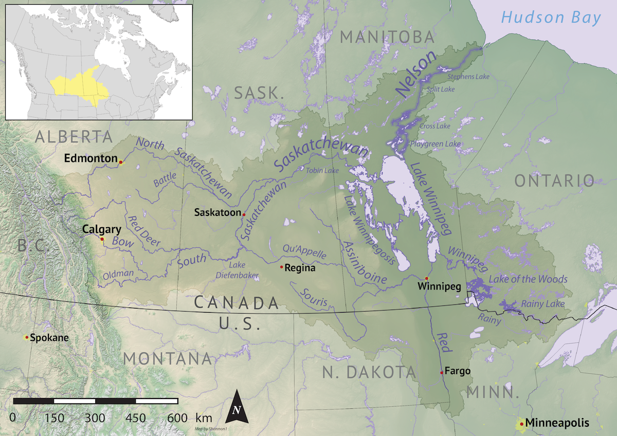
גודל התצוגה המקדימה הזאת: 800 × 565 פיקסלים. רזולוציות אחרות: 320 × 226 פיקסלים | 640 × 452 פיקסלים | 1,024 × 724 פיקסלים | 1,200 × 848 פיקסלים.
לקובץ המקורי (1,200 × 848 פיקסלים, גודל הקובץ: 1.72 מ"ב, סוג MIME: image/png)
זהו קובץ שמקורו במיזם ויקישיתוף. תיאורו בדף תיאור הקובץ המקורי (בעברית) מוצג למטה ויקישיתוף הוא מאגר תמונות וקובצי מדיה חופשיים. אתם יכולים לעזור. |
תקציר
| תיאור | English: Map of the Nelson River drainage basin. Data derived from NASA SRTM, Statistics Canada, US Geological Survey, Natural Earth, all public domain. |
| תאריך יצירה | |
| מקור | נוצר על־ידי מעלה היצירה |
| יוצר | Shannon1 |
רישיון
אני, בעל זכויות היוצרים על היצירה הזאת, מפרסם אותה בזאת תחת הרישיונות הבאים:
 | מוענקת בכך הרשות להעתיק, להפיץ או לשנות את המסמך הזה, לפי תנאי הרישיון לשימוש חופשי במסמכים של גנו, גרסה 1.2 או כל גרסה מאוחרת יותר שתפורסם על־ידי המוסד לתוכנה חופשית; ללא פרקים קבועים, ללא טקסט עטיפה קדמית וללא טקסט עטיפה אחורית. עותק של הרישיון כלול בפרק שכותרתו הרישיון לשימוש חופשי במסמכים של גנו. |
הקובץ הזה מתפרסם לפי תנאי רישיונות קריאייטיב קומונז ייחוס–שיתוף זהה 4.0 בין־לאומי, 3.0 לא מותאם, 2.5 כללי, 2.0 כללי ו־1.0 Generic.
- יש לך חופש:
- לשתף – להעתיק, להפיץ ולהעביר את העבודה
- לערבב בין עבודות – להתאים את העבודה
- תחת התנאים הבאים:
- ייחוס – יש לתת ייחוס הולם, לתת קישור לרישיון, ולציין אם נעשו שינויים. אפשר לעשות את זה בכל צורה סבירה, אבל לא בשום צורה שמשתמע ממנה שמעניק הרישיון תומך בך או בשימוש שלך.
- שיתוף זהה – יצירת רמיקס, שינוי או בנייה על סמך החומר הזה, תטיל עליך חובה להפיץ את התרומות שלך לפי תנאי רישיון זהה או תואם למקור.
אפשר לבחור את הרישיון שמתאים לך.
היסטוריית הקובץ
ניתן ללחוץ על תאריך/שעה כדי לראות את הקובץ כפי שנראה באותו זמן.
| תאריך/שעה | תמונה ממוזערת | ממדים | משתמש | הערה | |
|---|---|---|---|---|---|
| נוכחית | 07:41, 1 בנובמבר 2019 | | 848 × 1,200 (1.72 מ"ב) | Shannon1 | {{Information |description ={{en|1=Map of the Nelson River drainage basin. Data derived from NASA SRTM, Statistics Canada, US Geological Survey, Natural Earth, all public domain.}} |date =2019-10-30 |source =Own work |author =Shannon1 }} Category:Nelson River |
שימוש בקובץ
אין דפים המשתמשים בקובץ זה.
שימוש גלובלי בקובץ
אתרי הוויקי האחרים הבאים משתמשים בקובץ הזה:
- שימוש באתר af.wikipedia.org
- שימוש באתר be-tarask.wikipedia.org
- שימוש באתר be.wikipedia.org
- שימוש באתר bg.wikipedia.org
- שימוש באתר ca.wikipedia.org
- שימוש באתר cs.wikipedia.org
- שימוש באתר de.wikipedia.org
- שימוש באתר en.wikipedia.org
- Red River of the North
- Lake Winnipeg
- Pierre Gaultier de Varennes, sieur de La Vérendrye
- Nelson River
- Rainy River (Minnesota–Ontario)
- Winnipeg River
- Hudson Bay drainage basin
- User:Shannon1/Maps
- Canadian canoe routes
- User:Kayoty/sandbox
- Armstrong River (Manitoba)
- Red Deer River (Manitoba)
- Etomami River
- Fir River
- Pepaw River
- Piwei River
- Armit River
- Overflowing River
- Mossey River
- Lilian River
- שימוש באתר es.wikipedia.org
- שימוש באתר et.wikipedia.org
- שימוש באתר fi.wikipedia.org
- שימוש באתר fr.wikipedia.org
- שימוש באתר hr.wikipedia.org
- שימוש באתר hy.wikipedia.org
- שימוש באתר it.wikipedia.org
- שימוש באתר ja.wikipedia.org
- שימוש באתר kn.wikipedia.org
- שימוש באתר ko.wikipedia.org
- שימוש באתר lv.wikipedia.org
- שימוש באתר nl.wikipedia.org
צפייה בשימושים גלובליים נוספים של הקובץ הזה.
מטא־נתונים
Explore the world

United states
New York

Japan
Tokyo

Singapore
Singapore
