
 Français
 Italiano
גודל התצוגה המקדימה הזאת: 800 × 535 פיקסלים. רזולוציות אחרות: 320 × 214 פיקסלים | 640 × 428 פיקסלים | 1,024 × 685 פיקסלים | 1,426 × 954 פיקסלים.
לקובץ המקורי (1,426 × 954 פיקסלים, גודל הקובץ: 289 ק"ב, סוג MIME: image/jpeg)
זהו קובץ שמקורו במיזם ויקישיתוף. תיאורו בדף תיאור הקובץ המקורי (בעברית) מוצג למטה ויקישיתוף הוא מאגר תמונות וקובצי מדיה חופשיים. אתם יכולים לעזור. |
תקציר
| תיאור | English: Official Congaree National Park map from the brochure, showing the visitor center, trails, roads, and campsites. |
| תאריך יצירה | |
| מקור | Congaree National Park Maps (https://npmaps.com/congaree) |
| יוצר | U.S. National Park Service, restoration/cleanup by National Park Maps (https://npmaps.com) |
| גרסאות אחרות | 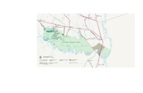 |
רישיון
| This image or media file contains material based on a work of a National Park Service employee, created as part of that person's official duties. As a work of the U.S. federal government, such work is in the public domain in the United States. See the NPS website and NPS copyright policy for more information. |
היסטוריית הקובץ
ניתן ללחוץ על תאריך/שעה כדי לראות את הקובץ כפי שנראה באותו זמן.
| תאריך/שעה | תמונה ממוזערת | ממדים | משתמש | הערה | |
|---|---|---|---|---|---|
| נוכחית | 23:08, 16 במאי 2017 | | 954 × 1,426 (289 ק"ב) | RKBot | =={{int:filedesc}}== {{Information |description= {{en|1=Official Congaree National Park map from the brochure, showing the visitor center, trails, roads, and campsites.}} |date= 2016-01-24 |source= U.S. National Park Service (http://npmaps.com/wp-conte... |
שימוש בקובץ
אין דפים המשתמשים בקובץ זה.
שימוש גלובלי בקובץ
אתרי הוויקי האחרים הבאים משתמשים בקובץ הזה:
- שימוש באתר de.wikipedia.org
- שימוש באתר he.wikipedia.org
Explore the world

United states
New York

Japan
Tokyo

Singapore
Singapore
