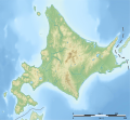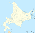
גודל התצוגה המקדימה הזאת מסוג PNG של קובץ ה־SVG הזה: 647 × 599 פיקסלים. רזולוציות אחרות: 259 × 240 פיקסלים | 518 × 480 פיקסלים | 829 × 768 פיקסלים | 1,106 × 1,024 פיקסלים | 2,211 × 2,048 פיקסלים | 1,720 × 1,593 פיקסלים.
לקובץ המקורי (קובץ SVG, הגודל המקורי: 1,720 × 1,593 פיקסלים, גודל הקובץ: 1.64 מ"ב)
היסטוריית הקובץ
ניתן ללחוץ על תאריך/שעה כדי לראות את הקובץ כפי שנראה באותו זמן.
| תאריך/שעה | תמונה ממוזערת | ממדים | משתמש | הערה | |
|---|---|---|---|---|---|
| נוכחית | 13:15, 3 באפריל 2022 |  | 1,593 × 1,720 (1.64 מ"ב) | Peka | add some lakes, change a disputed border (continuous line to dashed line) |
| 02:12, 2 ביולי 2013 |  | 1,593 × 1,720 (1.64 מ"ב) | Bourrichon | cours d'eau 1,5px | |
| 01:54, 2 ביולי 2013 |  | 1,593 × 1,720 (1.64 מ"ב) | Bourrichon | ||
| 01:42, 2 ביולי 2013 |  | 1,593 × 1,720 (926 ק"ב) | Bourrichon | ||
| 01:39, 2 ביולי 2013 |  | 1,593 × 1,720 (926 ק"ב) | Bourrichon | -bug | |
| 01:34, 2 ביולי 2013 |  | 1,593 × 1,720 (1.55 מ"ב) | Bourrichon | == {{int:filedesc}} == {{Location|43|00|00|N|142|00|00|E|scale:5000000}} {{Information |Description= {{fr|Carte topographique vierge de l'île de fr:Hokkaidō, au Japon, destinée à la géolocalisation.}} {{de|Topographische Karte... |
שימוש בקובץ
אין דפים המשתמשים בקובץ זה.
שימוש גלובלי בקובץ
אתרי הוויקי האחרים הבאים משתמשים בקובץ הזה:
- שימוש באתר ar.wikipedia.org
- שימוש באתר ceb.wikipedia.org
- שימוש באתר de.wikipedia.org
- Usu (Vulkan)
- Fernsehturm Sapporo
- Daisetsuzan-Nationalpark
- Meakan-dake
- Shiretoko-Halbinsel
- Apoi
- Tōya-See
- Mashū-See
- Rebun (Insel)
- Rishiri (Insel)
- Akan-Mashū-Nationalpark
- Okushiri (Insel)
- Saroma-See
- Shakotan-Halbinsel
- Nemuro-Straße
- Diskussion:Fernsehturm Sapporo
- Oshima-Ōshima
- Kussharo-See
- Vorlage:Positionskarte Japan Präfektur Hokkaidō
- Kamome-jima
- Yōtei-zan
- Tokachi-dake
- Burg Matsumae
- Shikotsu-Tōya-Nationalpark
- Kushiro-Shitsugen-Nationalpark
- Rishiri-Rebun-Sarobetsu-Nationalpark
- Oshima-Halbinsel
- Abashiri-Quasi-Nationalpark
- Hidaka-Sanmyaku-Erimo-Quasi-Nationalpark
- Shokanbetsu-Teuri-Yagishiri-Quasi-Nationalpark
- Niseko-Shakotan-Otaru-Kaigan-Quasi-Nationalpark
- Ōnuma-Quasi-Nationalpark
- Hagoromo-Wasserfall
- Shikotsu-See
- Eniwa (Vulkan)
- Teine (Berg)
- Makomanai-Park
- Hokkaidō-Erdbeben 2018
- Esanbe Hanakita Kojima
- Inkura-Wasserfall
- Garō-Wasserfall
- Ōdōri-Park
- Kojima (Hokkaidō)
- Rausu-dake
- Benutzer:Lupe/Baustelle/Hidaka-Sanmyaku-Erimo-Quasi-Nationalpark
- Akan (See)
- Kutcharo-See
צפייה בשימושים גלובליים נוספים של הקובץ הזה.


 Français
 Italiano


