
 Français
 Italiano
לקובץ המקורי (10,000 × 4,972 פיקסלים, גודל הקובץ: 1.85 מ"ב, סוג MIME: image/png)
זהו קובץ שמקורו במיזם ויקישיתוף. תיאורו בדף תיאור הקובץ המקורי (בעברית) מוצג למטה ויקישיתוף הוא מאגר תמונות וקובצי מדיה חופשיים. אתם יכולים לעזור. |
 | File:Tropical wet forests.svg הוא גרסה וקטורית של קובץ זה. יש להשתמש בו במקום קובץ ה־PNG הזה כאשר הוא איננו נחות. File:800px-tropical wet forests.png → File:Tropical wet forests.svg למידע נוסף, אנא ראו Help:SVG. |  |
תקציר
רישיון
| ברצוני, בעלי זכויות היוצרים על יצירה זו, לשחרר יצירה זו לנחלת הכלל. זה תקף בכל העולם. יש מדינות שבהן הדבר אינו אפשרי על פי חוק, אם כך: אני מעניק לכל אחד את הזכות להשתמש בעבודה זו לכל מטרה שהיא, ללא תנאים כלשהם, אלא אם כן תנאים כאלה נדרשים על פי חוק. |
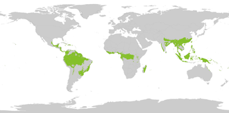
Using the following source : "Biome boundary. The humid tropical biome was delineated using the World Wildlife Fund terrestrial ecoregions map. This map was modified to exclude mountain and coastal forest mosaic ecoregions in Africa." on Global Forest Monitoring Project archive copy at the Wayback Machine
Original data licensed as : "Provided data are available for use for valid scientific, conservation, and educational purposes as long as proper citations are used. We ask that you credit the Humid Tropical Monitoring data as follows: Hansen, M.C., Stehman, S.V., Potapov, P.V., Loveland, T.R., Townshend, J.R.G., DeFries, R.S., Pittman, K.W., Stolle, F., Steininger, M.K., Carroll, M., Dimiceli, C. (2008) Humid tropical forest clearing from 2000 to 2005 quantified using multi-temporal and multi-resolution remotely sensed data. PNAS, 105(27), 9439-9444."
Shapefile : htropbiome.zip archive copy at the Wayback Machine ; World background from "Country Area (2010-11-01) Filename: cnty_area" from UNEP archive copy at the Wayback Machine.
היסטוריית הקובץ
ניתן ללחוץ על תאריך/שעה כדי לראות את הקובץ כפי שנראה באותו זמן.
| תאריך/שעה | תמונה ממוזערת | ממדים | משתמש | הערה | |
|---|---|---|---|---|---|
| נוכחית | 19:40, 27 באוגוסט 2022 | | 4,972 × 10,000 (1.85 מ"ב) | Yerachmiel C | higher resolution raster map |
| 17:58, 9 בספטמבר 2012 |  | 396 × 800 (93 ק"ב) | Oeneis | The original file was very coarse, especially in the Amazon basin. This version is more accurate and comes from a known reference. Using the following source : "Biome boundary. The humid tropical biome was delineated using the World Wildlife Fund terr... | |
| 00:15, 11 בינואר 2007 |  | 407 × 800 (30 ק"ב) | Moyogo | Tropical wet forests |
שימוש בקובץ
הדף הבא משתמש בקובץ הזה:
שימוש גלובלי בקובץ
אתרי הוויקי האחרים הבאים משתמשים בקובץ הזה:
- שימוש באתר af.wikipedia.org
- שימוש באתר an.wikipedia.org
- שימוש באתר ar.wikipedia.org
- שימוש באתר arz.wikipedia.org
- שימוש באתר ast.wikipedia.org
- שימוש באתר az.wikipedia.org
- שימוש באתר ba.wikipedia.org
- שימוש באתר be-tarask.wikipedia.org
- שימוש באתר be.wikipedia.org
- שימוש באתר bg.wikipedia.org
- שימוש באתר bn.wikipedia.org
- שימוש באתר br.wikipedia.org
- שימוש באתר bs.wikipedia.org
- שימוש באתר ca.wikipedia.org
- שימוש באתר ce.wikipedia.org
- שימוש באתר ckb.wikipedia.org
- שימוש באתר cs.wikipedia.org
- שימוש באתר cv.wikipedia.org
- שימוש באתר cy.wikipedia.org
- שימוש באתר da.wikipedia.org
- שימוש באתר da.wikibooks.org
- שימוש באתר en.wikipedia.org
- שימוש באתר eo.wikipedia.org
- Pluvarbaro
- Tropikaj kaj subtropikaj humidaj foliarbaroj
- Nord-hindoĉinaj subtropikaj arbaroj
- Arbaroj de Sunda Lando sur Kerangas
- Kategorio:Tropikaj kaj subtropikaj humidaj foliarbaroj
- Atlantik-marbordaj ekvatoraj arbaroj
- Himalajaj subtropikaj foliarbaroj
- Odiŝaj kvazaŭĉiamverdaj arbaroj
- Meghalajaj subtropikaj arbaroj
- Ludovik-insularaj pluvarbaroj
- Mizoramaj, manipuraj kaj kaĉinaj pluvarbaroj
- Borneaj malaltaĵaj pluvarbaroj
- Maskarenaj arbaroj
- Jiangnanaj subtropikaj ĉiamverdaj arbaroj
- Orientafrikaj montarbaroj
- Tenaserimaj-sudtajlandaj kvazaŭĉiamverdaj pluvarbaroj
- Borneaj montaraj pluvarbaroj
- Albert-riftaj montarbaroj
צפייה בשימושים גלובליים נוספים של הקובץ הזה.
מטא־נתונים
Explore the world

United states
New York

Japan
Tokyo

Singapore
Singapore
