
 Français
 Italiano
Taille de cet aperçu : 485 × 600 pixels. Autres résolutions : 194 × 240 pixels | 388 × 480 pixels | 621 × 768 pixels | 828 × 1 024 pixels | 1 672 × 2 068 pixels.
Fichier d’origine (1 672 × 2 068 pixels, taille du fichier : 932 kio, type MIME : image/png)
 | Ce fichier a été transféré sur Commons depuis wts.oldwikivoyage, de façon semi-automatique. Toutes les informations d'origine sont encore présentes, et il faut les vérifier. Il peut y avoir des erreurs dans la description, les catégories peuvent ne pas être les bonnes, ne faites pas confiance à cette description tant que ce bandeau est présent. Vous pouvez enlever le bandeau une fois que la description et les catégories ont été vérifiées. Vérifiez maintenant ! |
Description
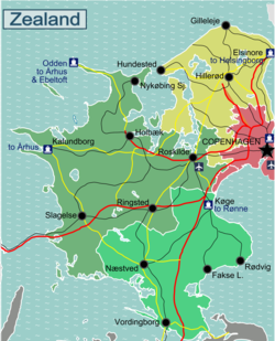
| Description | Regional map of Zealand. Regional Map of Zealand with Roads and Railways
|
| Date | |
| Source | http://da.wikipedia.org/wiki/Skabelon:Kortpositioner_Sj%C3%A6lland |
| Auteur | Stefan Ertmann & Eric Frohne |
Conditions d’utilisation
Ce fichier est disponible selon les termes de la licence Creative Commons Attribution – Partage dans les Mêmes Conditions 2.0 Générique
- Vous êtes libre :
- de partager – de copier, distribuer et transmettre cette œuvre
- d’adapter – de modifier cette œuvre
- Sous les conditions suivantes :
- paternité – Vous devez donner les informations appropriées concernant l'auteur, fournir un lien vers la licence et indiquer si des modifications ont été faites. Vous pouvez faire cela par tout moyen raisonnable, mais en aucune façon suggérant que l’auteur vous soutient ou approuve l’utilisation que vous en faites.
- partage à l’identique – Si vous modifiez, transformez ou vous basez sur cet élément, vous devez distribuer votre contribution sous une license identique ou compatible à celle de l’original.
Journal des téléversements d’origine
| Ce fichier a été téléversé à partir de Wikivoyage WTS. |
La page de description originale était ici. Tous les noms d'utilisateur qui suivent se rapportent à wts.wikivoyage-old.
- 2009-09-14 19:34 (WT-shared) Sertmann[lien mort] 604×1002 (293602 bytes) == Summary == {{Imagecredit|credit=Stefan Ertmann & Eric Frohne|captureDate=September 2009|location=Zealand|source=http://da.wikipedia.org/w (Import from wikitravel.org/shared)
- 2009-09-14 20:15 (WT-shared) Sertmann[lien mort] 451×750 (202129 bytes) (Import from wikitravel.org/shared)
- 2010-02-28 16:59 (WT-shared) ClausHansen[lien mort] 2227×3707 (1320514 bytes) (Import from wikitravel.org/shared)
- 2010-08-21 15:30 (WT-shared) ClausHansen[lien mort] 1337×1654 (589937 bytes) (Import from wikitravel.org/shared)
- 2010-08-24 11:56 (WT-shared) ClausHansen[lien mort] 1672×2068 (954580 bytes) Changed border between south and west to follow municipalities (Import from wikitravel.org/shared)
Historique du fichier
Cliquer sur une date et heure pour voir le fichier tel qu'il était à ce moment-là.
| Date et heure | Vignette | Dimensions | Utilisateur | Commentaire | |
|---|---|---|---|---|---|
| actuel | 18 décembre 2012 à 04:02 | | 1 672 × 2 068 (932 kio) | OgreBot | (BOT): Reverting to most recent version before archival |
| 18 décembre 2012 à 04:02 |  | 1 337 × 1 654 (576 kio) | OgreBot | (BOT): Uploading old version of file from wts.wikivoyage; originally uploaded on 2010-08-21 15:30:41 by (WT-shared) ClausHansen | |
| 18 décembre 2012 à 04:02 |  | 2 227 × 3 707 (1,26 Mio) | OgreBot | (BOT): Uploading old version of file from wts.wikivoyage; originally uploaded on 2010-02-28 16:59:53 by (WT-shared) ClausHansen | |
| 18 décembre 2012 à 04:02 |  | 451 × 750 (197 kio) | OgreBot | (BOT): Uploading old version of file from wts.wikivoyage; originally uploaded on 2009-09-14 20:15:08 by (WT-shared) Sertmann | |
| 18 décembre 2012 à 04:02 |  | 604 × 1 002 (287 kio) | OgreBot | (BOT): Uploading old version of file from wts.wikivoyage; originally uploaded on 2009-09-14 19:34:33 by (WT-shared) Sertmann | |
| 18 novembre 2012 à 03:32 |  | 1 672 × 2 068 (932 kio) | MGA73bot2 | {{BotMoveToCommons|wts.oldwikivoyage|year={{subst:CURRENTYEAR}}|month={{subst:CURRENTMONTHNAME}}|day={{subst:CURRENTDAY}}}} == {{int:filedesc}} == {{Information |description=Regional map of Zealand. Regional Map of Zealand with Roads and Railways<br>SV... |
Utilisation du fichier
La page suivante utilise ce fichier :
Usage global du fichier
Les autres wikis suivants utilisent ce fichier :
- Utilisation sur en.wikivoyage.org
- Utilisation sur he.wikivoyage.org
- Utilisation sur it.wikivoyage.org
- Utilisation sur vi.wikivoyage.org
Métadonnées
Explore the world

United states
New York

Japan
Tokyo

Singapore
Singapore
