
 Français
 Italiano
Taille de cet aperçu : 800 × 530 pixels. Autres résolutions : 320 × 212 pixels | 640 × 424 pixels | 1 024 × 679 pixels | 1 280 × 848 pixels | 2 560 × 1 697 pixels | 4 231 × 2 804 pixels.
Fichier d’origine (4 231 × 2 804 pixels, taille du fichier : 1,05 Mio, type MIME : image/png)
 | Cette image (de type meteorology) devrait être recréée dans un format vectoriel, en tant que fichier SVG. Cela offrirait plusieurs avantages : voir Commons:Media for cleanup pour plus d’informations. Si une version SVG de cette image est déjà disponible, merci de bien vouloir l’envoyer. Après cela, remplacez ce modèle par {{vector version available|nouveau nom d’image.svg}}. |
Description
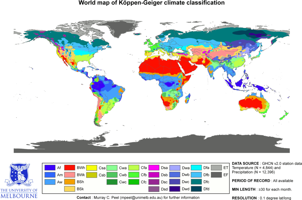
| Description | English: Updated world map of the Köppen-Geiger climate classification. Français : Carte du monde mise à jour de la classification Köppen-Geiger des climats.
| |||||||||||||||
| Date | ||||||||||||||||
| Source | Peel, M. C. and Finlayson, B. L. and McMahon, T. A. (2007). "Updated world map of the Köppen-Geiger climate classification". Hydrology Earth and System Sciences 11: 1633-1644. ISSN 1027-5606. | |||||||||||||||
| Auteur | Peel, M. C., Finlayson, B. L., and McMahon, T. A. (University of Melbourne). | |||||||||||||||
| Autorisation (Réutilisation de ce fichier) |
| |||||||||||||||
| Autres versions | Œuvres dérivées de ce fichier : Köppen World Map (retouched version).png | |||||||||||||||
.png)
Related maps
User Jeroenvrp made for these continents and areas a cropped and resized version:
- Africa Köppen Map.png
- Asia Köppen Map.png
- Australia-Oceania Köppen Map.png
- Europe Köppen Map.png
- North America Köppen Map.png
- Russia Köppen Map.png
- South America Köppen Map.png
- West Asia Köppen Map.png.
User LordToran made from the same data these maps:
- Klimagürtel-der-erde-eisklima.png
- Klimagürtel-der-erde-gemäßigte-zone.png
- Klimagürtel-der-erde-polargebiete.png
- Klimagürtel-der-erde-subtropen.png
- Klimagürtel-der-erde-tropen.png
- Klimagürtel-der-erde-tundra.png
- Klimagürtel-der-erde-warmgemäßigte-zone.png
- Klimagürtel-der-erde.png
- Klimagürtel-der-erde.svg
- Klimate-humidität.png
- Köppen-geiger-hessd-2007.svg
- Köppen-vereinfacht.svg
- Trockenklimate.png
Conditions d’utilisation
Ce fichier est disponible selon les termes de la licence Creative Commons Attribution – Partage dans les Mêmes Conditions 3.0 Non Transposé.
- Vous êtes libre :
- de partager – de copier, distribuer et transmettre cette œuvre
- d’adapter – de modifier cette œuvre
- Sous les conditions suivantes :
- paternité – Vous devez donner les informations appropriées concernant l'auteur, fournir un lien vers la licence et indiquer si des modifications ont été faites. Vous pouvez faire cela par tout moyen raisonnable, mais en aucune façon suggérant que l’auteur vous soutient ou approuve l’utilisation que vous en faites.
- partage à l’identique – Si vous modifiez, transformez ou vous basez sur cet élément, vous devez distribuer votre contribution sous une license identique ou compatible à celle de l’original.
Historique du fichier
Cliquer sur une date et heure pour voir le fichier tel qu'il était à ce moment-là.
| Date et heure | Vignette | Dimensions | Utilisateur | Commentaire | |
|---|---|---|---|---|---|
| actuel | 13 juin 2018 à 17:15 | | 4 231 × 2 804 (1,05 Mio) | Trecătorul răcit | Correct areas of the Pyreneos, Alps, Carpathes, Balkans and Caucasus |
| 20 février 2018 à 15:57 |  | 4 231 × 2 804 (1,05 Mio) | Maphobbyist | The Caspian coastal lowland of Iran has a humid subtropical climate (Köppen classification: Cfa). | |
| 24 juin 2017 à 19:26 |  | 4 231 × 2 804 (742 kio) | Alatab | Costa Rican Central Valley has a Cwb clasification (Oceanic climate). | |
| 24 septembre 2016 à 23:59 |  | 4 231 × 2 804 (786 kio) | Maphobbyist | Köppen system is based on the concept that climate types are correlated with the natural vegetation. | |
| 21 juin 2013 à 21:08 |  | 4 231 × 2 804 (336 kio) | Underlying lk | derivative works based on this map should be uploaded with a different name, rather than overwrite the original UoM file. | |
| 13 mars 2011 à 12:13 |  | 4 231 × 2 804 (1,11 Mio) | Maphobbyist | Painted the Caspian Sea as white as it should have been, because the Köppen system is based on the concept that climate types are correlated with the natural vegetation. Thus with Köppen, climate zone boundaries have been selected with vegetation distri | |
| 5 mars 2010 à 23:41 |  | 4 231 × 2 804 (336 kio) | Aiyizo | Cropped white space, compressed with pngout. I've also converted the image to indexed mode with an optimal 64 color palette. This introduces minor alaising effects to the region edges, but it gives a massive reduction in file size. I think this is a go | |
| 12 octobre 2007 à 22:35 |  | 4 250 × 2 815 (2,09 Mio) | Retireduser-vfs199s31yvbtxsfmygg | ||
| 12 octobre 2007 à 22:05 |  | 6 708 × 4 443 (3,21 Mio) | Retireduser-vfs199s31yvbtxsfmygg | Citation: '''Peel, M. C., Finlayson, B. L., and McMahon, T. A.: Updated world map of the Köppen-Geiger climate classification, Hydrol. Earth Syst. Sci., 11, 1633-1644, 2007.''' {{Information |Description= Updated world map of the Köppen-Geiger climate |
Utilisation du fichier
Aucune page n’utilise ce fichier.
Usage global du fichier
Les autres wikis suivants utilisent ce fichier :
- Utilisation sur an.wikipedia.org
- Utilisation sur bg.wikipedia.org
- Utilisation sur bs.wikipedia.org
- Utilisation sur ca.wikipedia.org
- Clima
- Climatologia
- Clima mediterrani
- Clima continental
- Clima atlàntic
- Clima temperat
- Classificació climàtica de Köppen
- Clima tropical
- Clima equatorial
- Clima polar
- Plantilla:Climes
- Clima àrid
- Categoria:Climes tipus
- Semidesert
- Wladimir Köppen
- Clima subtropical humit
- Clima de la sabana
- Clima tropical monsònic
- Utilisation sur cs.wikipedia.org
- Utilisation sur da.wikipedia.org
- Utilisation sur en.wikipedia.org
- Utilisation sur en.wikibooks.org
- Utilisation sur et.wikipedia.org
- Utilisation sur fr.wikipedia.org
- Utilisation sur fy.wikipedia.org
- Utilisation sur he.wikipedia.org
- Utilisation sur hi.wikipedia.org
- Utilisation sur hr.wikipedia.org
- Utilisation sur id.wikipedia.org
- Utilisation sur it.wikipedia.org
- Utilisation sur ja.wikibooks.org
- Utilisation sur kk.wikipedia.org
Voir davantage sur l’utilisation globale de ce fichier.
Métadonnées
Explore the world

United states
New York

Japan
Tokyo

Singapore
Singapore
