
 Français
 Italiano
Taille de cet aperçu : 444 × 599 pixels. Autres résolutions : 178 × 240 pixels | 356 × 480 pixels | 569 × 768 pixels | 1 042 × 1 406 pixels.
Fichier d’origine (1 042 × 1 406 pixels, taille du fichier : 48 kio, type MIME : image/png)
Description
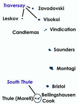
| Description | English: Map of South Sandwich Islands with names |
| Date | |
| Source | Travail personnel |
| Auteur | Ante Perkovic 09:21, 29 March 2007 (UTC) |
| Autres versions | Image:SSI-Blue.jpg |
Conditions d’utilisation
Moi, en tant que détenteur des droits d’auteur sur cette œuvre, je la publie sous les licences suivantes :
 | Vous avez la permission de copier, distribuer et modifier ce document selon les termes de la GNU Free Documentation License version 1.2 ou toute version ultérieure publiée par la Free Software Foundation, sans sections inaltérables, sans texte de première page de couverture et sans texte de dernière page de couverture. Un exemplaire de la licence est inclus dans la section intitulée GNU Free Documentation License. |
| Ce fichier est disponible selon les termes de la licence Creative Commons Attribution – Partage dans les Mêmes Conditions 3.0 Non Transposé. | ||
| ||
| Ce bandeau de licence a été ajouté à ce fichier dans le cadre de la procédure de mise à jour des licences des images sous GFDL. |
Ce fichier est sous licence Creative Commons Attribution – Partage dans les Mêmes Conditions 2.5 Générique, 2.0 Générique et 1.0 Générique.
- Vous êtes libre :
- de partager – de copier, distribuer et transmettre cette œuvre
- d’adapter – de modifier cette œuvre
- Sous les conditions suivantes :
- paternité – Vous devez donner les informations appropriées concernant l'auteur, fournir un lien vers la licence et indiquer si des modifications ont été faites. Vous pouvez faire cela par tout moyen raisonnable, mais en aucune façon suggérant que l’auteur vous soutient ou approuve l’utilisation que vous en faites.
- partage à l’identique – Si vous modifiez, transformez ou vous basez sur cet élément, vous devez distribuer votre contribution sous une license identique ou compatible à celle de l’original.
Vous pouvez choisir l’une de ces licences.
Historique du fichier
Cliquer sur une date et heure pour voir le fichier tel qu'il était à ce moment-là.
| Date et heure | Vignette | Dimensions | Utilisateur | Commentaire | |
|---|---|---|---|---|---|
| actuel | 29 mars 2007 à 10:12 | | 1 042 × 1 406 (48 kio) | Argo Navis | {{Information |Description= Map of South Sandwich Islands with names |Source= |Date=09:21, 29 March 2007 (UTC) |Author= Ante Perkovic 09:21, 29 March 2007 (UTC) |Permission= |other_versions= Image:SSI-Blue.jpg }} [[category:Sou |
| 29 mars 2007 à 10:01 |  | 1 042 × 1 406 (39 kio) | Argo Navis | {{Information |Description= Map of South Sandwich Islands with names |Source= |Date=~~~~~ |Author= ~~~~ |Permission= |other_versions= Image:SSI-Blue.jpg }} | |
| 29 mars 2007 à 09:21 |  | 1 042 × 1 406 (39 kio) | Argo Navis | {{Information |Description= Map of South Sandwich Islands with names |Source= |Date=~~~~~ |Author= ~~~~ |Permission= |other_versions= Image:SSI-Blue.jpg }} |
Utilisation du fichier
Aucune page n’utilise ce fichier.
Usage global du fichier
Les autres wikis suivants utilisent ce fichier :
- Utilisation sur cs.wikipedia.org
- Utilisation sur fr.wikipedia.org
- Utilisation sur fr.wiktionary.org
- Utilisation sur ja.wikipedia.org
- Utilisation sur nn.wikipedia.org
- Utilisation sur no.wikipedia.org
Explore the world

United states
New York

Japan
Tokyo

Singapore
Singapore
