
 Français
 Italiano
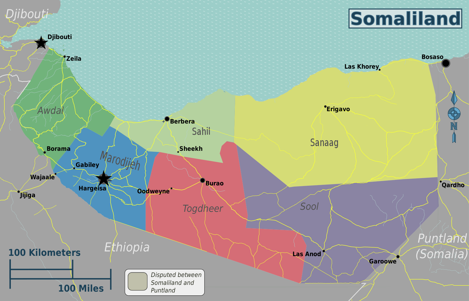
Taille de cet aperçu : 800 × 513 pixels. Autres résolutions : 320 × 205 pixels | 640 × 410 pixels | 1 024 × 657 pixels | 1 280 × 821 pixels | 1 600 × 1 026 pixels.
Fichier d’origine (1 600 × 1 026 pixels, taille du fichier : 556 kio, type MIME : image/png)
 | Ce fichier a été transféré sur Commons depuis wts.oldwikivoyage, de façon semi-automatique. Toutes les informations d'origine sont encore présentes, et il faut les vérifier. Il peut y avoir des erreurs dans la description, les catégories peuvent ne pas être les bonnes, ne faites pas confiance à cette description tant que ce bandeau est présent. Vous pouvez enlever le bandeau une fois que la description et les catégories ont été vérifiées. Vérifiez maintenant ! |
Description
| Description | English: Somaliland regions map. English version, Somaliland
|
| Date | |
| Source | File:Somaliland regions map.svg |
| Auteur | Peter Fitzgerald, OpenStreetMap [1] |
Conditions d’utilisation
Ce fichier est disponible selon les termes de la licence Creative Commons Attribution – Partage dans les Mêmes Conditions 2.0 Générique
- Vous êtes libre :
- de partager – de copier, distribuer et transmettre cette œuvre
- d’adapter – de modifier cette œuvre
- Sous les conditions suivantes :
- paternité – Vous devez donner les informations appropriées concernant l'auteur, fournir un lien vers la licence et indiquer si des modifications ont été faites. Vous pouvez faire cela par tout moyen raisonnable, mais en aucune façon suggérant que l’auteur vous soutient ou approuve l’utilisation que vous en faites.
- partage à l’identique – Si vous modifiez, transformez ou vous basez sur cet élément, vous devez distribuer votre contribution sous une license identique ou compatible à celle de l’original.
Journal des téléversements d’origine
| Ce fichier a été téléversé à partir de Wikivoyage WTS. |
La page de description originale était ici. Tous les noms d'utilisateur qui suivent se rapportent à wts.wikivoyage-old.
- 2012-10-30 01:51 Peterfitzgerald copie d'archive sur Wayback Machine 3008×1928 (1130785 bytes) {{Imagecredit|credit=Peter Fitzgerald, OpenStreetMap [http://openstreetmap.org]|captureDate=29 October 2012|location=Somaliland|source=[[:File:Somaliland regions map.svg]]|caption=Somaliland regions map|description=English version}}{{Map|Somaliland}}
Historique du fichier
Cliquer sur une date et heure pour voir le fichier tel qu'il était à ce moment-là.
| Date et heure | Vignette | Dimensions | Utilisateur | Commentaire | |
|---|---|---|---|---|---|
| actuel | 2 mai 2021 à 22:40 | | 1 600 × 1 026 (556 kio) | Siirski | update borders to show Sahil region and corrected eastern border |
| 20 juin 2020 à 18:03 |  | 3 008 × 1 928 (1,08 Mio) | Kzl55 | Reverted to version as of 02:45, 18 November 2012 (UTC) Restored long-standing stable version, the map is of regions within Somaliland | |
| 16 juin 2020 à 16:07 |  | 800 × 513 (296 kio) | Meelpringthusss | highlighted disputed area | |
| 18 novembre 2012 à 02:45 |  | 3 008 × 1 928 (1,08 Mio) | MGA73bot2 | {{BotMoveToCommons|wts.oldwikivoyage|year={{subst:CURRENTYEAR}}|month={{subst:CURRENTMONTHNAME}}|day={{subst:CURRENTDAY}}}} == {{int:filedesc}} == {{Information |description=Somaliland regions map. English version, Somaliland * Map of: Somaliland¤ |da... |
Utilisation du fichier
La page suivante utilise ce fichier :
Usage global du fichier
Les autres wikis suivants utilisent ce fichier :
- Utilisation sur en.wikipedia.org
- Utilisation sur incubator.wikimedia.org
- Utilisation sur it.wikivoyage.org
- Utilisation sur vi.wikivoyage.org
Explore the world

United states
New York

Japan
Tokyo

Singapore
Singapore
