
 Français
 Italiano
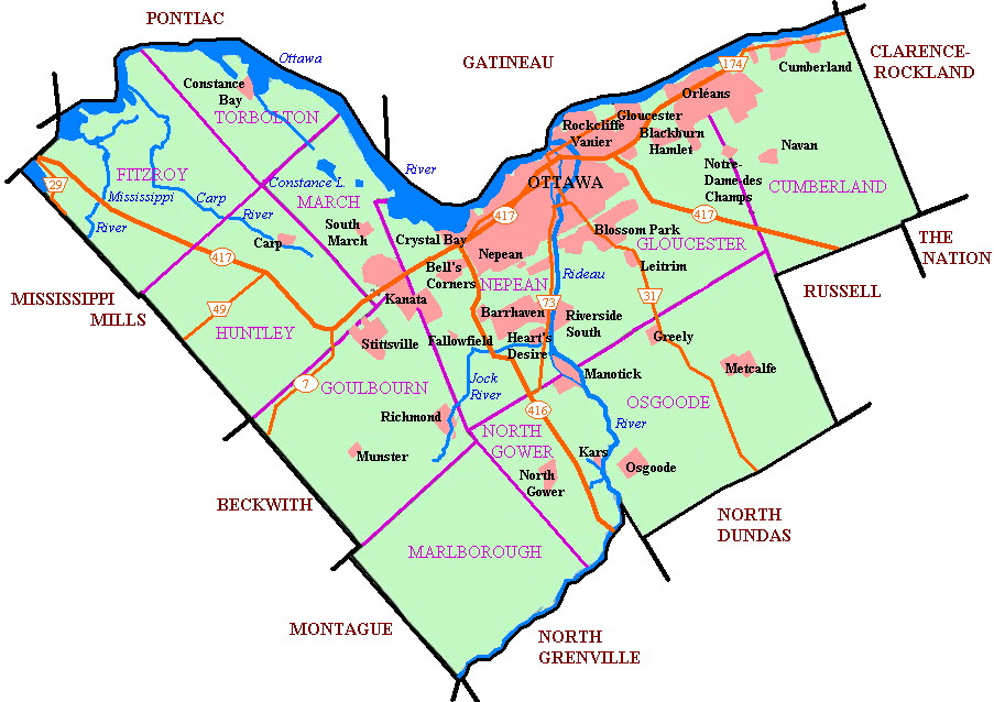
Fichier d’origine (903 × 638 pixels, taille du fichier : 165 kio, type MIME : image/png)
 | Cette image (de type city map) devrait être recréée dans un format vectoriel, en tant que fichier SVG. Cela offrirait plusieurs avantages : voir Commons:Media for cleanup pour plus d’informations. Si une version SVG de cette image est déjà disponible, merci de bien vouloir l’envoyer. Après cela, remplacez ce modèle par {{vector version available|nouveau nom d’image.svg}}. Note : des données vectorielles existent et sont disponibles sur File:Ottawa map.svg. |
Originally uploaded to en wiki as Image:Newottawamap.png by creator en:User:Earl Andrew on March 16, 2005 Released by author to the public domain.
| | Cette image a été (ou est ici-même) mise à disposition dans le domaine public par son auteur, Earl Andrew dans le projet anglais Wikipédia. Ceci s'applique partout dans le monde. Au cas où cela n'est pas possible légalement : |
Format
Historique du fichier
Cliquer sur une date et heure pour voir le fichier tel qu'il était à ce moment-là.
| Date et heure | Vignette | Dimensions | Utilisateur | Commentaire | |
|---|---|---|---|---|---|
| actuel | 1 mai 2005 à 08:56 | | 903 × 638 (165 kio) | Peregrine981 | Originally uploaded to en wiki as Image:Newottawamap.png by creator en:User:Early Andrew on March 16, 2005 Released by author to the public domain. {{PD}} Category:Ottawa Category:Maps |
Utilisation du fichier
Aucune page n’utilise ce fichier.
Usage global du fichier
Les autres wikis suivants utilisent ce fichier :
- Utilisation sur ang.wikipedia.org
- Utilisation sur ar.wikipedia.org
- Utilisation sur ay.wikipedia.org
- Utilisation sur bn.wikipedia.org
- Utilisation sur ca.wikipedia.org
- Utilisation sur de.wikipedia.org
- Utilisation sur de.wikivoyage.org
- Utilisation sur en.wikipedia.org
- Ottawa
- Rockcliffe Park
- Riverview, Ottawa
- Westboro, Ottawa
- Blossom Park
- Kanata, Ontario
- Cumberland, Ontario
- New Edinburgh
- Old Ottawa South
- Richmond, Ontario
- TD Place Stadium
- Dow's Lake
- Heron Gate
- Children's Hospital of Eastern Ontario
- Orleans, Ontario
- Barrhaven
- Downtown Ottawa
- Old Ottawa East
- Cumberland, Ottawa
- Stittsville
- Constance Bay
- Ottawa Macdonald–Cartier International Airport
- Ottawa/Rockcliffe Airport
- Carp Airport
- Munster, Ontario
- List of airports in the Ottawa area
- Kars/Rideau Valley Air Park
- Centrepointe
- Manotick
- Carp, Ontario
- Hintonburg
- Mechanicsville, Ottawa
- Dunrobin, Ontario
- Ottawa station
- Tremblay station
- Osgoode, Ontario
- Lindenlea
- Metcalfe, Ontario
- Britannia, Ottawa
- Burritts Rapids
- Huntley Township, Ontario
- Torbolton Township
- Talk:Ottawa station
Voir davantage sur l’utilisation globale de ce fichier.
Explore the world

United states
New York

Japan
Tokyo

Singapore
Singapore
