
 Français
 Italiano
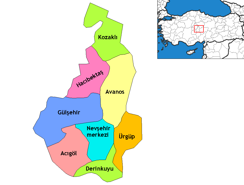
Taille de cet aperçu : 787 × 599 pixels. Autres résolutions : 315 × 240 pixels | 630 × 480 pixels | 1 011 × 770 pixels.
Fichier d’origine (1 011 × 770 pixels, taille du fichier : 28 kio, type MIME : image/png)
Description
| Description | Map of the districts of Nevşehir province in Turkey. Created by Rarelibra 16:38, 4 December 2006 (UTC) for public domain use, using MapInfo Professional v8.5 and various mapping resources. Edited by One Homo Sapiens Corrected text where İ,Ş,ı,ğ,or ş occurs in name. Source: [statoids-com]. Increased font size and enhanced color differences among adjacent districts. |
| Date | 15 avril 2007 (date de téléversement originale) |
| Source | La source n’a pas pu être reconnue automatiquement. « Travail personnel » supposé (étant donné la revendication de droit d’auteur). |
| Auteur | L’auteur n’a pas pu être identifié automatiquement. Il est supposé qu'il s'agit de : Denizz~commonswiki (étant donné la revendication de droit d’auteur). |
Conditions d’utilisation
| Moi, propriétaire des droits d’auteur sur cette œuvre, la place dans le domaine public. Ceci s'applique dans le monde entier. Dans certains pays, ceci peut ne pas être possible ; dans ce cas : J’accorde à toute personne le droit d’utiliser cette œuvre dans n’importe quel but, sans aucune condition, sauf celles requises par la loi. |
derivative works
Œuvres dérivées de ce fichier :
- Nevsehir districts Acigol.png
- Nevsehir districts Gulsehir.png
- Nevsehir districts Hacibektas.png
- Nevsehir districts Kozakli.png
Historique du fichier
Cliquer sur une date et heure pour voir le fichier tel qu'il était à ce moment-là.
| Date et heure | Vignette | Dimensions | Utilisateur | Commentaire | |
|---|---|---|---|---|---|
| actuel | 16 octobre 2009 à 23:40 | | 1 011 × 770 (28 kio) | ZooFari | Trimmed off border |
| 29 décembre 2008 à 01:46 |  | 1 056 × 816 (29 kio) | One Homo Sapiens | Corrected text where İ,Ş,ı,ğ,or ş occurs in name. Source: [statoids-com]. Increased font size and enhanced color differences among adjacent districts. | |
| 15 avril 2007 à 21:42 |  | 1 056 × 816 (28 kio) | Denizz~commonswiki | == Summary == Map of the districts of Nevşehir province in Turkey. Created by Rarelibra 16:38, 4 December 2006 (UTC) for public domain use, using MapInfo Professional v8.5 and various mapping resources. == Licensing == {{PD-self}} |
Utilisation du fichier
Aucune page n’utilise ce fichier.
Usage global du fichier
Les autres wikis suivants utilisent ce fichier :
- Utilisation sur ar.wikipedia.org
- Utilisation sur ast.wikipedia.org
- Utilisation sur av.wikipedia.org
- Utilisation sur az.wikipedia.org
- Utilisation sur be.wikipedia.org
- Utilisation sur ca.wikipedia.org
- Utilisation sur ceb.wikipedia.org
- Utilisation sur cs.wikipedia.org
- Utilisation sur de.wikipedia.org
- Utilisation sur diq.wikipedia.org
- Utilisation sur el.wikipedia.org
- Utilisation sur en.wikipedia.org
- Utilisation sur en.wiktionary.org
- Utilisation sur eo.wikipedia.org
- Utilisation sur es.wikipedia.org
- Utilisation sur eu.wikipedia.org
- Utilisation sur fa.wikipedia.org
Voir davantage sur l’utilisation globale de ce fichier.
Explore the world

United states
New York

Japan
Tokyo

Singapore
Singapore
