
 Français
 Italiano
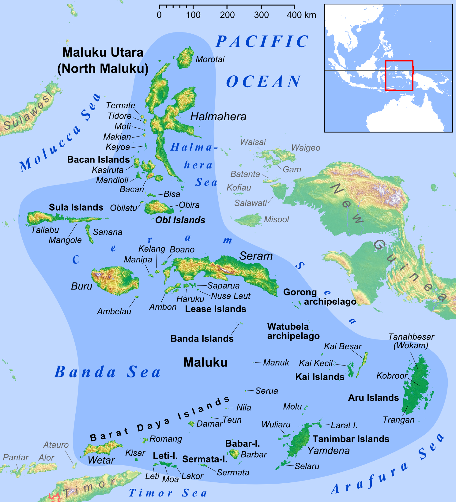
Taille de cet aperçu : 544 × 599 pixels. Autres résolutions : 218 × 240 pixels | 436 × 480 pixels | 697 × 768 pixels | 930 × 1 024 pixels | 1 489 × 1 640 pixels.
Fichier d’origine (1 489 × 1 640 pixels, taille du fichier : 1,08 Mio, type MIME : image/png)
Description
| Description | English: Map of Maluku Islands | ||
| Date | |||
| Source | own work, used: | ||
| Auteur | Lencer | ||
| Autres versions |
|


 | Cette carte a été créée ou améliorée dans le Kartenwerkstatt (Atelier cartographique allemand). Vous pouvez également y proposer des cartes à améliorer. |
Conditions d’utilisation
Moi, en tant que détenteur des droits d’auteur sur cette œuvre, je la publie sous la licence suivante :
Ce fichier est disponible selon les termes de la licence Creative Commons Attribution – Partage dans les Mêmes Conditions 3.0 Non Transposé.
- Vous êtes libre :
- de partager – de copier, distribuer et transmettre cette œuvre
- d’adapter – de modifier cette œuvre
- Sous les conditions suivantes :
- paternité – Vous devez donner les informations appropriées concernant l'auteur, fournir un lien vers la licence et indiquer si des modifications ont été faites. Vous pouvez faire cela par tout moyen raisonnable, mais en aucune façon suggérant que l’auteur vous soutient ou approuve l’utilisation que vous en faites.
- partage à l’identique – Si vous modifiez, transformez ou vous basez sur cet élément, vous devez distribuer votre contribution sous une license identique ou compatible à celle de l’original.
-
Historique du fichier
Cliquer sur une date et heure pour voir le fichier tel qu'il était à ce moment-là.
| Date et heure | Vignette | Dimensions | Utilisateur | Commentaire | |
|---|---|---|---|---|---|
| actuel | 26 février 2018 à 13:52 | | 1 489 × 1 640 (1,08 Mio) | Sebastian Wallroth | Removed border by cropping 1 % horizontally and 1 % vertically using CropTool with precise mode. |
| 28 mars 2013 à 13:04 |  | 1 499 × 1 650 (1,09 Mio) | Lencer | + Kayoa | |
| 24 mars 2013 à 18:10 |  | 1 499 × 1 650 (1,09 Mio) | Lencer | + Manuk, + Serua, + Teun, Haruku fixed | |
| 12 février 2013 à 09:45 |  | 1 500 × 1 651 (1,09 Mio) | Lencer | + Lease Islands | |
| 11 février 2013 à 15:29 |  | 1 500 × 1 651 (1,08 Mio) | Lencer | == {{int:filedesc}} == {{Information |Description= {{en|Map of Maluku Islands}} |Source=own work, used: * Maluku Locator Topography.png by User:Sadalmelik |Date=2013-02 |Author=[[User:L... |
Utilisation du fichier
La page suivante utilise ce fichier :
Usage global du fichier
Les autres wikis suivants utilisent ce fichier :
- Utilisation sur ace.wikipedia.org
- Utilisation sur af.wikipedia.org
- Utilisation sur ar.wikipedia.org
- Utilisation sur ast.wikipedia.org
- Utilisation sur az.wikipedia.org
- Utilisation sur ban.wikipedia.org
- Utilisation sur ba.wikipedia.org
- Utilisation sur bcl.wikipedia.org
- Utilisation sur bg.wikipedia.org
- Utilisation sur bm.wikipedia.org
- Utilisation sur bn.wikipedia.org
- Utilisation sur btm.wikipedia.org
- Utilisation sur ca.wikipedia.org
- Utilisation sur ceb.wikipedia.org
Voir davantage sur l’utilisation globale de ce fichier.
Métadonnées
Explore the world

United states
New York

Japan
Tokyo

Singapore
Singapore
