
 Français
 Italiano
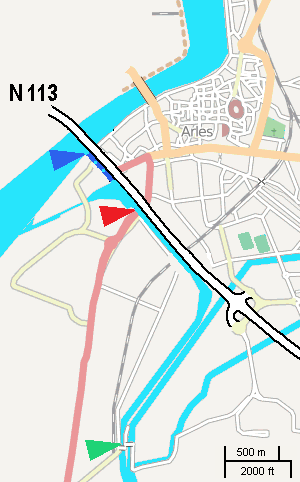
Pas de plus haute résolution disponible.
Langlois_and_Van_Gogh_bridges_locations_map.gif (300 × 482 pixels, taille du fichier : 20 kio, type MIME : image/gif)
| Description | English: This rough map, adapted from a screenshot from OSM, shows locations of Langlois bridge (red) and today's Van Gogh bridge (green). Dark blue shows the channel entrance as of 1888. |
| Date | |
| Source | self, using a screenshot from OpenSourceMaps |
| Auteur | user:W. |
| Autorisation (Réutilisation de ce fichier) | Ce fichier est disponible selon les termes de la licence Creative Commons Attribution – Partage dans les Mêmes Conditions 2.0 Générique
|
Historique du fichier
Cliquer sur une date et heure pour voir le fichier tel qu'il était à ce moment-là.
| Date et heure | Vignette | Dimensions | Utilisateur | Commentaire | |
|---|---|---|---|---|---|
| actuel | 5 novembre 2008 à 09:56 | | 300 × 482 (20 kio) | W. | {{Information |Description= |Source= |Date= |Author= |Permission= |other_versions= }} |
| 4 novembre 2008 à 12:07 |  | 300 × 482 (20 kio) | W. | {{Information |Description={{en|1=This rough map, adapted from a screenshot from OSM, shows locations of ''Langlois bridge'' (red) and today's ''Van Gogh bridge'' (green). Dark blue shows the channel entrance as of 1888.}} |Source=self, using a screenshot |
Utilisation du fichier
Aucune page n’utilise ce fichier.
Usage global du fichier
Les autres wikis suivants utilisent ce fichier :
- Utilisation sur de.wikipedia.org
- Utilisation sur en.wikipedia.org
- Utilisation sur eo.wikipedia.org
- Utilisation sur fr.wikipedia.org
Explore the world

United states
New York

Japan
Tokyo

Singapore
Singapore
