
 Français
 Italiano
Taille de cet aperçu PNG pour ce fichier SVG : 800 × 561 pixels. Autres résolutions : 320 × 225 pixels | 640 × 449 pixels | 1 024 × 719 pixels | 1 280 × 898 pixels | 2 560 × 1 796 pixels | 1 425 × 1 000 pixels.
Fichier d’origine (Fichier SVG, nominalement de 1 425 × 1 000 pixels, taille : 2,11 Mio)
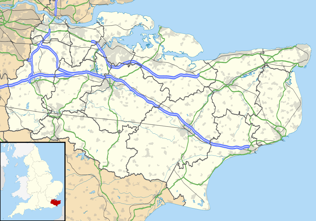
| Description | Map of Kent, UK with the following information shown:
Equirectangular map projection on WGS 84 datum, with N/S stretched 160% Geographic limits:
|
| Date | |
| Source |
|
| Auteur | Nilfanion, created using Ordnance Survey data |
| Autorisation (Réutilisation de ce fichier) | Ce fichier est disponible selon les termes de la licence Creative Commons Attribution – Partage dans les Mêmes Conditions 3.0 Non Transposé. Attribution: Contains Ordnance Survey data © Crown copyright and database right
|
| Autres versions | File:Kent UK district map (blank).svg - Blank map |
.svg)
Historique du fichier
Cliquer sur une date et heure pour voir le fichier tel qu'il était à ce moment-là.
| Date et heure | Vignette | Dimensions | Utilisateur | Commentaire | |
|---|---|---|---|---|---|
| actuel | 26 septembre 2010 à 18:58 | | 1 425 × 1 000 (2,11 Mio) | Nilfanion | {{Information |Description=Map of Kent, UK with the following information shown: *Administrative borders *Coastline, lakes and rivers *Roads and railways *Urban areas Equirectangular map projection on WGS 84 datum, with N/S stretched 160% Geo |
Utilisation du fichier
Aucune page n’utilise ce fichier.
Usage global du fichier
Les autres wikis suivants utilisent ce fichier :
- Utilisation sur ar.wikipedia.org
- Utilisation sur bg.wikipedia.org
- Utilisation sur br.wikipedia.org
- Utilisation sur ca.wikipedia.org
- Utilisation sur ceb.wikipedia.org
- Utilisation sur cs.wikipedia.org
- Utilisation sur cy.wikipedia.org
- Utilisation sur el.wikipedia.org
- Utilisation sur en.wikipedia.org
- Kent
- Lullingstone Roman Villa
- Dover
- Canterbury
- Chatham, Kent
- Dartford Crossing
- Hever Castle
- Sandwich, Kent
- Folkestone
- Minster-in-Thanet
- Aylesford
- Maidstone
- Rochester, Kent
- Snodland
- Romney Marsh
- Dover Castle
- Walmer Castle
- Walmer
- Wye, Kent
- Isle of Sheppey
- Bedgebury National Pinetum
- Gravesend
- Eythorne
- Ramsgate
- Herne Bay
- Sevenoaks
- Tonbridge
- Stansted, Kent
- Royal Tunbridge Wells
- Ashford, Kent
- Broadstairs
- Hythe, Kent
- Queenborough
- New Romney
- Whitstable
- Otford
- Paddock Wood
- Knole
Voir davantage sur l’utilisation globale de ce fichier.
Métadonnées
Explore the world

United states
New York

Japan
Tokyo

Singapore
Singapore
