
 Français
 Italiano
Taille de cet aperçu PNG pour ce fichier SVG : 585 × 600 pixels. Autres résolutions : 234 × 240 pixels | 468 × 480 pixels | 749 × 768 pixels | 999 × 1 024 pixels | 1 998 × 2 048 pixels | 995 × 1 020 pixels.
Fichier d’origine (Fichier SVG, nominalement de 995 × 1 020 pixels, taille : 698 kio)
Description
| Lieu de la prise de vue | | Voir cet endroit et d’autres images sur : OpenStreetMap |
|---|
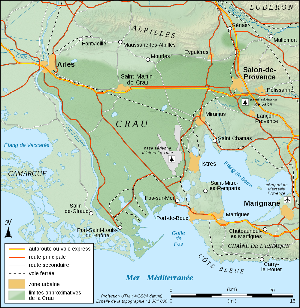
| Description | English: Physical map in French of the approximate area of Crau's biome, France. Note: The background map is a raster image embedded in the SVG file. Français : Carte physique en français des limites approximatives du biome de la Crau, France. Note : Le fond de carte est une image bitmap embarquée dans le fichier SVG. UTM projection ; WGS84 datum ; shaded relief (composite image of N-W, W and N lightning positions) | ||
| Date | |||
| Source | Travail personnel
| ||
| Auteur | Eric Gaba (Sting - fr:Sting) | ||
| Autorisation (Réutilisation de ce fichier) |
|
| Ce fichier SVG contient du texte encapsulé pouvant facilement être traduit dans votre langue en utilisant n'importe quel éditeur de fichier SVG ou de texte, ou par l'outil de traduction de fichiers SVG. Pour plus d'informations, voir : A propos de la traduction des fichiers SVG. |
Conditions d’utilisation
Moi, en tant que détenteur des droits d’auteur sur cette œuvre, je la publie sous les licences suivantes :
 | Vous avez la permission de copier, distribuer et modifier ce document selon les termes de la GNU Free Documentation License version 1.2 ou toute version ultérieure publiée par la Free Software Foundation, sans sections inaltérables, sans texte de première page de couverture et sans texte de dernière page de couverture. Un exemplaire de la licence est inclus dans la section intitulée GNU Free Documentation License. |
Ce fichier est sous licence Creative Commons Attribution - Partage Dans Les Mêmes Conditions 4.0 International, 3.0 Non Transposé, 2.5 Générique, 2.0 Générique et 1.0 Générique.
- Vous êtes libre :
- de partager – de copier, distribuer et transmettre cette œuvre
- d’adapter – de modifier cette œuvre
- Sous les conditions suivantes :
- paternité – Vous devez donner les informations appropriées concernant l'auteur, fournir un lien vers la licence et indiquer si des modifications ont été faites. Vous pouvez faire cela par tout moyen raisonnable, mais en aucune façon suggérant que l’auteur vous soutient ou approuve l’utilisation que vous en faites.
- partage à l’identique – Si vous modifiez, transformez ou vous basez sur cet élément, vous devez distribuer votre contribution sous une license identique ou compatible à celle de l’original.
Vous pouvez choisir l’une de ces licences.
Historique du fichier
Cliquer sur une date et heure pour voir le fichier tel qu'il était à ce moment-là.
| Date et heure | Vignette | Dimensions | Utilisateur | Commentaire | |
|---|---|---|---|---|---|
| actuel | 4 septembre 2008 à 12:33 | | 995 × 1 020 (698 kio) | Sting | Icons of the air bases |
| 20 août 2008 à 01:49 |  | 995 × 1 020 (695 kio) | Sting | Roads classification | |
| 19 août 2008 à 06:51 |  | 995 × 1 020 (695 kio) | Sting | + extend of Istres AB's area | |
| 19 août 2008 à 06:37 |  | 995 × 1 020 (694 kio) | Sting | More corrections | |
| 19 août 2008 à 06:26 |  | 995 × 1 020 (679 kio) | Sting | + 1 air base | |
| 19 août 2008 à 06:07 |  | 995 × 1 020 (677 kio) | Sting | Correction ; + airport and air base | |
| 18 août 2008 à 20:43 |  | 995 × 1 020 (671 kio) | Sting | == Summary == {{Location|43|34|00|N|04|51|00|E|scale:200000}} <br/> {{Information |Description={{en|Physical map in French of the approximate area of Crau's biome, France.<br/>''Note:'' The background map is a ras |
Utilisation du fichier
Aucune page n’utilise ce fichier.
Usage global du fichier
Les autres wikis suivants utilisent ce fichier :
- Utilisation sur de.wikipedia.org
- Utilisation sur en.wikipedia.org
- Utilisation sur fr.wikipedia.org
- Utilisation sur fr.wikinews.org
- Utilisation sur fr.wiktionary.org
- Utilisation sur it.wikipedia.org
- Utilisation sur ja.wikipedia.org
- Utilisation sur nl.wikipedia.org
- Utilisation sur pl.wikipedia.org
- Utilisation sur sq.wikipedia.org
- Utilisation sur www.wikidata.org
Explore the world

United states
New York

Japan
Tokyo

Singapore
Singapore
