
 Français
 Italiano
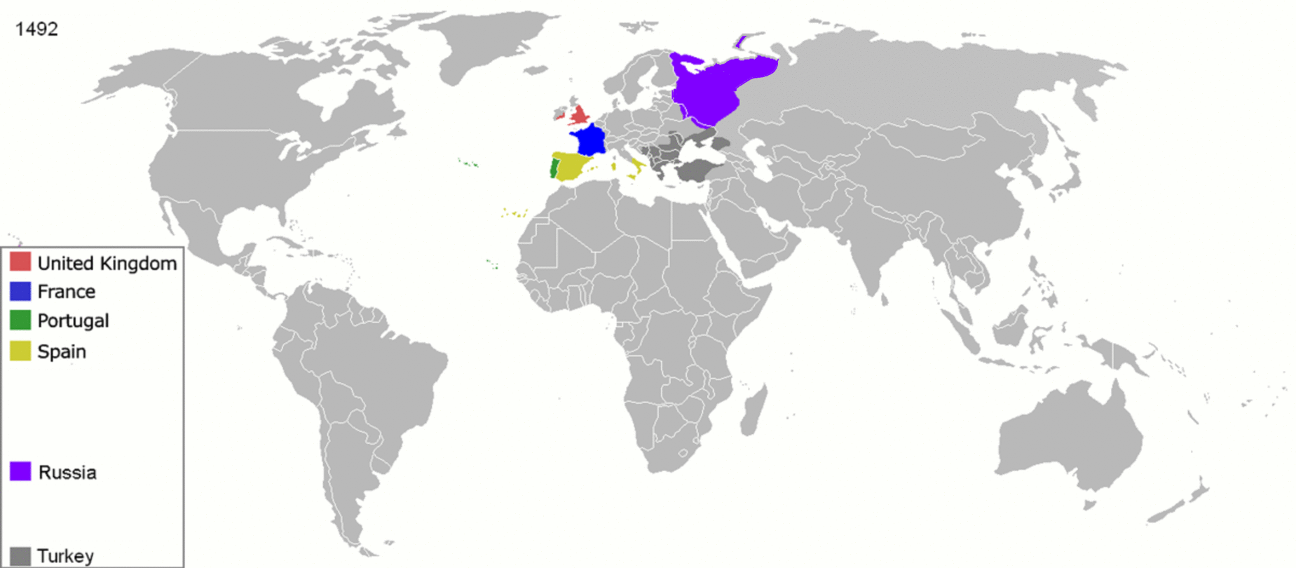
Fichier d’origine (1 849 × 810 pixels, taille du fichier : 2,08 Mio, type MIME : image/gif, en boucle, 12 trames, 48 s)
Description
| Description | English: Map indicating the territories colonized by the European powers, United States and Japan.
Русский: Карта с указанием территорий, колонизированных Европейскими державами, Соединёнными штатами и Японией. | ||||||||||||||||
| Date | 23 juin 2008 (date de téléversement originale) | ||||||||||||||||
| Source | Transféré de en.wikipedia à Commons. | ||||||||||||||||
| Auteur | ArdadN sur Wikipédia anglais | ||||||||||||||||
| Autres versions | The maps can be seen separately by using this template:
Œuvres dérivées de ce fichier : | ||||||||||||||||
.gif)
.jpg)
._LOC_2001620596.jpg)
Conditions d’utilisation
| Moi, propriétaire des droits d’auteur sur cette œuvre, la place dans le domaine public. Ceci s'applique dans le monde entier. Dans certains pays, ceci peut ne pas être possible ; dans ce cas : J’accorde à toute personne le droit d’utiliser cette œuvre dans n’importe quel but, sans aucune condition, sauf celles requises par la loi. |
Historique du fichier
Cliquer sur une date et heure pour voir le fichier tel qu'il était à ce moment-là.
| Date et heure | Vignette | Dimensions | Utilisateur | Commentaire | |
|---|---|---|---|---|---|
| actuel | 5 octobre 2020 à 15:40 | | 1 849 × 810 (2,08 Mio) | Ориенталист | Colour correction |
| 10 mai 2020 à 14:19 |  | 800 × 379 (606 kio) | Ориенталист | Cosmetic changes | |
| 5 avril 2020 à 09:39 |  | 800 × 351 (561 kio) | Ориенталист | Last time i forgot 1914. Аdded it, little changes | |
| 4 avril 2020 à 09:49 |  | 800 × 351 (495 kio) | Ориенталист | Changed maps for 1492, 1550, 1660, 1754. Added a map for 1600. | |
| 9 janvier 2019 à 11:29 |  | 1 425 × 625 (101 kio) | ArdadN | fixed Ireland 1754, Morocco 1914, Russian-German border 1885 and 1914, German-French border 1885 and 1914, German-Danish border 1885, Austria and Sudetenland 1938 | |
| 23 juillet 2018 à 08:54 |  | 1 425 × 625 (101 kio) | SuperSucker | fix - believe in 1938 ethiopia was under european occupation as well.. italy had taken the capital Addis-Abeba in 1936 indeed | |
| 4 juin 2012 à 20:27 |  | 1 425 × 625 (101 kio) | Mnlk | i corrected the error that falsly depicted ethiopia as colony of fascist italy | |
| 19 février 2011 à 19:49 |  | 1 425 × 625 (246 kio) | NordNordWest | corrected according to http://de.wikipedia.org/w/index.php?title=Benutzer_Diskussion%3ANordNordWest&action=historysubmit&diff=85468547&oldid=85447379 | |
| 18 février 2011 à 19:40 |  | 1 425 × 625 (236 kio) | NordNordWest | corrected according to http://de.wikipedia.org/w/index.php?title=Benutzer_Diskussion%3ANordNordWest&action=historysubmit&diff=85447379&oldid=85351900 | |
| 16 septembre 2010 à 19:42 |  | 1 425 × 625 (257 kio) | NordNordWest | further corrections |
Utilisation du fichier
Aucune page n’utilise ce fichier.
Usage global du fichier
Les autres wikis suivants utilisent ce fichier :
- Utilisation sur ar.wikipedia.org
- Utilisation sur arz.wikipedia.org
- Utilisation sur av.wikipedia.org
- Utilisation sur azb.wikipedia.org
- Utilisation sur az.wikipedia.org
- Utilisation sur ba.wikipedia.org
- Utilisation sur be-tarask.wikipedia.org
- Utilisation sur be.wikipedia.org
- Utilisation sur bg.wikipedia.org
- Utilisation sur bn.wikipedia.org
- Utilisation sur bn.wikibooks.org
- Utilisation sur ce.wikipedia.org
- Utilisation sur crh.wikipedia.org
- Utilisation sur cs.wikipedia.org
- Utilisation sur da.wikipedia.org
- Utilisation sur de.wikipedia.org
- Utilisation sur diq.wikipedia.org
- Utilisation sur en.wikipedia.org
- History of Europe
- Early modern period
- Maritime history
- Colonial empire
- History of colonialism
- User:Palaeovia
- Portal:Maps/Maps/World
- Portal:Maps/Maps/World/18
- History of globalization
- User talk:AtomAtom
- User:Kazkaskazkasako/Books/History
- Outline of globalization
- Decoloniality
- Wikipedia:Graphics Lab/Map workshop/Archive/Apr 2014
Voir davantage sur l’utilisation globale de ce fichier.
Métadonnées
Explore the world

United states
New York

Japan
Tokyo

Singapore
Singapore
