
 Français
 Italiano
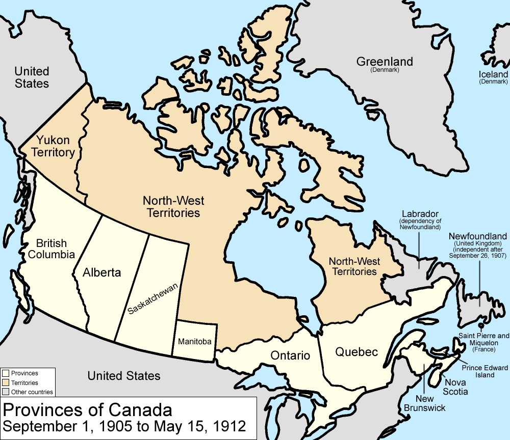
Fichier d’origine (1 000 × 864 pixels, taille du fichier : 63 kio, type MIME : image/png)
Description
| Description | Map of the provinces and territories of Canada as they were between 1905 and 1912. On September 1 1905, Alberta and Saskatchewan were created from parts of the North-West Territories and the District of Keewatin; the remainder of the District of Keewatin was remerged into the North-West Territories. On May 15 1912, parts of the North-West Territories were given to Manitoba, Ontario, and Quebec. Also note that in 1912, the official name dropped the hyphen, changing to "Northwest Territories". Made by User:Golbez. |
| Date | 13 février 2006 (date de téléversement originale) |
| Source | La source n’a pas pu être reconnue automatiquement. « Travail personnel » supposé (étant donné la revendication de droit d’auteur). |
| Auteur | L’auteur n’a pas pu être identifié automatiquement. Il est supposé qu'il s'agit de : Golbez (étant donné la revendication de droit d’auteur). |
Conditions d’utilisation
 | Vous avez la permission de copier, distribuer et modifier ce document selon les termes de la GNU Free Documentation License version 1.2 ou toute version ultérieure publiée par la Free Software Foundation, sans sections inaltérables, sans texte de première page de couverture et sans texte de dernière page de couverture. Un exemplaire de la licence est inclus dans la section intitulée GNU Free Documentation License. |
| Ce fichier est disponible selon les termes de la licence Creative Commons Attribution – Partage dans les Mêmes Conditions 3.0 Non Transposé. | ||
| ||
| Ce bandeau de licence a été ajouté à ce fichier dans le cadre de la procédure de mise à jour des licences des images sous GFDL. |
- Vous êtes libre :
- de partager – de copier, distribuer et transmettre cette œuvre
- d’adapter – de modifier cette œuvre
- Sous les conditions suivantes :
- paternité – Vous devez donner les informations appropriées concernant l'auteur, fournir un lien vers la licence et indiquer si des modifications ont été faites. Vous pouvez faire cela par tout moyen raisonnable, mais en aucune façon suggérant que l’auteur vous soutient ou approuve l’utilisation que vous en faites.
Historique du fichier
Cliquer sur une date et heure pour voir le fichier tel qu'il était à ce moment-là.
| Date et heure | Vignette | Dimensions | Utilisateur | Commentaire | |
|---|---|---|---|---|---|
| actuel | 14 juillet 2009 à 17:22 | | 1 000 × 864 (63 kio) | Golbez | New color scheme, other borders |
| 7 août 2006 à 09:59 |  | 1 000 × 864 (50 kio) | Golbez | with legend | |
| 18 février 2006 à 02:24 |  | 1 000 × 864 (49 kio) | Golbez | Better version | |
| 13 février 2006 à 23:49 |  | 1 000 × 864 (43 kio) | Golbez | better colors | |
| 13 février 2006 à 07:14 |  | 1 000 × 864 (42 kio) | Golbez | Map of the provinces and territories of Canada as they were between 1905 and 1912. On September 1 1905, Alberta and Saskatchewan were created from parts of the North-West Territories. On May 15 1912, parts of the North-West Territories were given to Manit |
Utilisation du fichier
Aucune page n’utilise ce fichier.
Usage global du fichier
Les autres wikis suivants utilisent ce fichier :
- Utilisation sur ast.wikipedia.org
- Utilisation sur de.wikipedia.org
- Utilisation sur en.wikipedia.org
- Utilisation sur es.wikipedia.org
- Utilisation sur fr.wikipedia.org
- Utilisation sur fy.wikipedia.org
- Utilisation sur gl.wikipedia.org
- Utilisation sur it.wikipedia.org
- Utilisation sur no.wikipedia.org
- Utilisation sur pt.wikipedia.org
- Utilisation sur ru.wikipedia.org
- Utilisation sur sv.wikipedia.org
- Utilisation sur uk.wikipedia.org
- Utilisation sur vi.wikipedia.org
- Utilisation sur www.wikidata.org
- Utilisation sur zh.wikipedia.org
Explore the world

United states
New York

Japan
Tokyo

Singapore
Singapore
