
 Français
 Italiano
Archivo original (5490 × 5490 píxeles; tamaño de archivo: 172,49 MB; tipo MIME: image/tiff)
Resumen
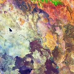
| Descripción | English: Captured on 1 October 2018 by the Copernicus Sentinel-2A satellite, this image features part of northeast Kenya – an area east of the East African Rift. The region tends to be very arid and this false-colour image has been processed to highlight different types of rock, soil and sand in pinks, purples and yellows. The bright green at the top of the image depicts vegetation, but the rest of the area appears relatively devoid of vegetation. Several dry river beds can also be seen etched into the landscape and the black shape in the middle-left appears to be an area of freshly burnt land. The lack of water has, at times, led to clashes between clans over access to water and pasture for cattle. When the rains do come, however, this dry dusty land can burst into life and turn a rich green. Part of the ‘great north road’ can also been seen running from the bottom-left to the top-right. The road is one of the best in the country, linking Nairobi in the south of the country to Ethiopia. The northern 500-km stretch from Isiolo to the Kenyan–Ethiopian border town of Moyale took about nine years to build and was completed recently, but has reduced travel time from Nairobi to Moyale from three days to about 12 hours and opened up new opportunities for trade and business. Moyale can be seen in the top-right of the image. Copernicus Sentinel-2 is a two-satellite mission. Each satellite carries a high-resolution camera that images Earth’s surface in 13 spectral bands. The mission is mostly used to track changes in the way land is being used and to monitor the health of our vegetation. This Copernicus Sentinel-2A image is also featured on the Earth from Space video programme. |
| Fecha | |
| Fuente | http://www.esa.int/spaceinimages/Images/2019/02/Northeast_Kenya |
| Autor | European Space Agency |
| Permiso (Reutilización de este archivo) | contains modified Copernicus Sentinel data (2018), processed by ESA, CC BY-SA 3.0 IGO |
| Otras versiones |
|

Licencia
This media was created by the European Space Agency (ESA). Where expressly so stated, images or videos are covered by the Creative Commons Attribution-ShareAlike 3.0 IGO (CC BY-SA 3.0 IGO) licence, ESA being an Intergovernmental Organisation (IGO), as defined by the CC BY-SA 3.0 IGO licence. The user is allowed under the terms and conditions of the CC BY-SA 3.0 IGO license to Reproduce, Distribute and Publicly Perform the ESA images and videos released under CC BY-SA 3.0 IGO licence and the Adaptations thereof, without further explicit permission being necessary, for as long as the user complies with the conditions and restrictions set forth in the CC BY-SA 3.0 IGO licence, these including that:
See the ESA Creative Commons copyright notice for complete information, and this article for additional details. |  | |
Este archivo se encuentra bajo la licencia Creative Commons Atribución Compartir-Igual 3.0 IGO. Atribución: ESA, CC BY-SA IGO 3.0
| ||
 | Esta imagen contiene datos que provienen de un satélite del Programa Copérnico, como Sentinel-1, Sentinel 2 o Sentinel-3. Se require atribución cuando se utilice esta imagen. Atribución: Contiene datos modificados de Copernicus Sentinel 2018 El uso de datos Sentinel del Programa Cópernico está regulado por la legislación europea: Reglamento Delegado (UE) No 1159/2013 de la Comisión y el Reglamento (UE) No 377/2014. Los pasajes relevantes son:
Se permitirá el acceso gratuito a los datos dedicados del GMES y a la información de servicio del GMES a través de las plataformas de difusión del GMES [...].
Se dará acceso a los datos dedicados del GMES y a la información de servicio del GMES a los efectos que se detallan a continuación, siempre y cuando sean lícitos:
Los datos dedicados del GMES y la información de servicio del GMES podrán utilizarse en todo el mundo sin limitación de tiempo.
Los datos dedicados del GMES y la información de servicio del GMES se facilitarán a los usuarios sin ninguna garantía explícita o implícita, incluyendo lo tocante a la calidad y la idoneidad para cualesquiera fines. |
Historial del archivo
Haz clic sobre una fecha y hora para ver el archivo tal como apareció en ese momento.
| Fecha y hora | Miniatura | Dimensiones | Usuario | Comentario | |
|---|---|---|---|---|---|
| actual | 01:10 9 feb 2019 |  | 5490 × 5490 (172,49 MB) | Don-vip | User created page with UploadWizard |
Usos del archivo
No hay páginas que enlacen a este archivo.
Metadatos
Explore the world

United states
New York

Japan
Tokyo

Singapore
Singapore
