
 Français
 Italiano
Archivo original (archivo SVG, nominalmente 254 × 254 píxeles, tamaño de archivo: 407 kB)
_-_MLI_-_UNOCHA.svg)
Resumen
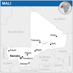
| Descripción | English: Locator map of Mali. |
| Fecha | |
| Fuente | English: Mali Locator Map (ReliefWeb) |
| Autor | |
| SVG desarrollo |
Licencia
- Eres libre:
- de compartir – de copiar, distribuir y transmitir el trabajo
- de remezclar – de adaptar el trabajo
- Bajo las siguientes condiciones:
- atribución – Debes otorgar el crédito correspondiente, proporcionar un enlace a la licencia e indicar si realizaste algún cambio. Puedes hacerlo de cualquier manera razonable pero no de manera que sugiera que el licenciante te respalda a ti o al uso que hagas del trabajo.
 This map is part of a collection of 216 free country maps, created by the UN Office for the Coordination of Humanitarian Affairs (OCHA), to be used in print, web or broadcast products. The ReliefWeb Location Maps released here are maps that highlight a country, its capital, major populated places and the surrounding regions. Attribution Requirements Using the map without modifications: ensure that the sources and the disclaimer are below the map. Credit as follows: "Credit: OCHA". For use with alteration: remove the OCHA logo and disclaimer following any modification to the map, but keep the data sources as mentioned below the map. Credit the modified map as follows: "Based on OCHA map". You are responsible for the content of your map. We are keen to receive your feedback and hear how you used OCHA's maps. We would be grateful if you would notify us by e-mail and share your work with us. UN Disclaimer The designations employed and the presentation of material of this map do not imply the expression of any opinion whatsoever on the part of the Secretariat of the United Nations concerning the legal status of any country, territory, city or area or of its authorities or concerning the delimitation of its frontiers or boundaries. |
Historial del archivo
Haz clic sobre una fecha y hora para ver el archivo tal como apareció en ese momento.
| Fecha y hora | Miniatura | Dimensiones | Usuario | Comentario | |
|---|---|---|---|---|---|
| actual | 01:46 29 mar 2015 | | 254 × 254 (407 kB) | Pharos | update |
| 03:31 18 nov 2014 |  | 254 × 254 (407 kB) | Pharos | try without logo for now | |
| 23:52 7 may 2014 |  | 254 × 254 (376 kB) | UN OCHA maps bot | == {{int:filedesc}} == {{Information |description={{en|1=Locator map of Mali.}} |date=2013 |source={{en|1=[http://reliefweb.int/map/mali/mali-location-map-2013 Mali Locator Map (ReliefWeb)]}} |author={{en|1=[[w:en:United Nations Office fo... |
Usos del archivo
No hay páginas que enlacen a este archivo.
Uso global del archivo
Las wikis siguientes utilizan este archivo:
- Uso en arz.wikipedia.org
- Uso en ast.wikipedia.org
- Uso en azb.wikipedia.org
- Uso en bh.wikipedia.org
- Uso en bn.wikipedia.org
- Uso en ca.wikipedia.org
- Uso en dag.wikipedia.org
- Uso en de.wikivoyage.org
- Uso en dga.wikipedia.org
- Uso en diq.wikipedia.org
- Uso en dty.wikipedia.org
- Uso en en.wikipedia.org
- Uso en eo.wikinews.org
- Uso en ff.wikipedia.org
- Uso en fi.wikipedia.org
- Uso en fr.wikinews.org
- Uso en fr.wikivoyage.org
- Uso en ga.wikipedia.org
- Uso en gd.wikipedia.org
- Uso en gl.wikipedia.org
- Uso en gpe.wikipedia.org
- Uso en gu.wikipedia.org
- Uso en ha.wikipedia.org
- Uso en he.wikivoyage.org
- Uso en hi.wikipedia.org
- Uso en ht.wikipedia.org
- Uso en ia.wikipedia.org
- Uso en id.wikipedia.org
- Uso en ig.wikipedia.org
- Uso en ilo.wikipedia.org
- Uso en incubator.wikimedia.org
- Uso en kab.wikipedia.org
- Uso en knc.wikipedia.org
- Uso en mg.wikipedia.org
- Uso en mt.wikipedia.org
- Uso en ne.wikipedia.org
- Uso en nqo.wikipedia.org
- Uso en pl.wikipedia.org
- Uso en rw.wikipedia.org
- Uso en sco.wikipedia.org
- Uso en sd.wikipedia.org
- Uso en te.wikipedia.org
Ver más uso global de este archivo.
_-_MLI_-_UNOCHA.svg)
Metadatos
_-_MLI_-_UNOCHA.svg)
Explore the world

United states
New York

Japan
Tokyo

Singapore
Singapore
