
 Français
 Italiano
Archivo original (2944 × 3058 píxeles; tamaño de archivo: 5,98 MB; tipo MIME: image/jpeg)
Resumen
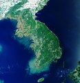
| Descripción | English: The Korean Peninsula in East Asia can be seen in this image captured by the Copernicus Sentinel-3 mission. The peninsula is over 900 km long and is located between the Sea of Japan, also known as the East Sea, to the east and the Yellow Sea to the west. The peninsula is divided into two countries – the Democratic People's Republic of Korea (North Korea) and the Republic of Korea (South Korea). North Korea is divided into nine provinces, with Pyongyang as the capital. Pyongyang, which can be seen in light grey in the upper left of the image, lies on the banks of the Taedong River and on a flat plain about 50 km inland from the Korea Bay. The capital of South Korea is Seoul, which is in the northwest of the country, slightly inland and around 50 km south of the North Korean border. As the image shows, the Korean peninsula is mostly mountainous and rocky, making less than 20% of the land suitable for farming. The Yellow Sea owes its name to the silt-laden waters from the Chinese rivers that empty into it. It is also one of the largest shallow areas of continental shelf in the world with an average depth of around 50 m. The waters off the coast of Korea are considered among the best in the world for fishing. The warm and cold currents attract a wide variety of species and the numerous islands, inlets and reefs provide excellent fishing grounds. Sentinel-3 is a two-satellite mission to supply the coverage and data delivery needed for Europe’s Copernicus environmental monitoring programme. Each satellite’s instrument package includes an optical sensor to monitor changes in the colour of Earth’s surfaces. It can be used, for example, to monitor ocean biology and water quality. This image, which was captured on 21 May 2019, is also featured on the Earth from Space video programme. |
| Fecha | 18 de octubre de 2019 (fecha de carga) |
| Fuente | Korean Peninsula |
| Autor | European Space Agency |
| Otras versiones |
|
| Activity | Observing the Earth |
| Mission | Sentinel-3 |
| Set | Earth observation image of the week |
| System | Copernicus |
Licencia
 | Esta imagen contiene datos que provienen de un satélite del Programa Copérnico, como Sentinel-1, Sentinel 2 o Sentinel-3. Se require atribución cuando se utilice esta imagen. Atribución: Contiene datos modificados de Copernicus Sentinel 2019 El uso de datos Sentinel del Programa Cópernico está regulado por la legislación europea: Reglamento Delegado (UE) No 1159/2013 de la Comisión y el Reglamento (UE) No 377/2014. Los pasajes relevantes son:
Se permitirá el acceso gratuito a los datos dedicados del GMES y a la información de servicio del GMES a través de las plataformas de difusión del GMES [...].
Se dará acceso a los datos dedicados del GMES y a la información de servicio del GMES a los efectos que se detallan a continuación, siempre y cuando sean lícitos:
Los datos dedicados del GMES y la información de servicio del GMES podrán utilizarse en todo el mundo sin limitación de tiempo.
Los datos dedicados del GMES y la información de servicio del GMES se facilitarán a los usuarios sin ninguna garantía explícita o implícita, incluyendo lo tocante a la calidad y la idoneidad para cualesquiera fines. |
This media was created by the European Space Agency (ESA). Where expressly so stated, images or videos are covered by the Creative Commons Attribution-ShareAlike 3.0 IGO (CC BY-SA 3.0 IGO) licence, ESA being an Intergovernmental Organisation (IGO), as defined by the CC BY-SA 3.0 IGO licence. The user is allowed under the terms and conditions of the CC BY-SA 3.0 IGO license to Reproduce, Distribute and Publicly Perform the ESA images and videos released under CC BY-SA 3.0 IGO licence and the Adaptations thereof, without further explicit permission being necessary, for as long as the user complies with the conditions and restrictions set forth in the CC BY-SA 3.0 IGO licence, these including that:
See the ESA Creative Commons copyright notice for complete information, and this article for additional details. |  | |
Este archivo se encuentra bajo la licencia Creative Commons Atribución Compartir-Igual 3.0 IGO. Atribución: ESA, CC BY-SA IGO 3.0
| ||
Historial del archivo
Haz clic sobre una fecha y hora para ver el archivo tal como apareció en ese momento.
| Fecha y hora | Miniatura | Dimensiones | Usuario | Comentario | |
|---|---|---|---|---|---|
| actual | 13:04 7 jun 2020 | | 2944 × 3058 (5,98 MB) | OptimusPrimeBot | #Spacemedia - Upload of https://www.esa.int/var/esa/storage/images/esa_multimedia/images/2019/10/korean_peninsula/21108288-1-eng-GB/Korean_Peninsula.jpg via Commons:Spacemedia |
Usos del archivo
No hay páginas que enlacen a este archivo.
Uso global del archivo
Las wikis siguientes utilizan este archivo:
Metadatos
Explore the world

United states
New York

Japan
Tokyo

Singapore
Singapore
