
 Français
 Italiano
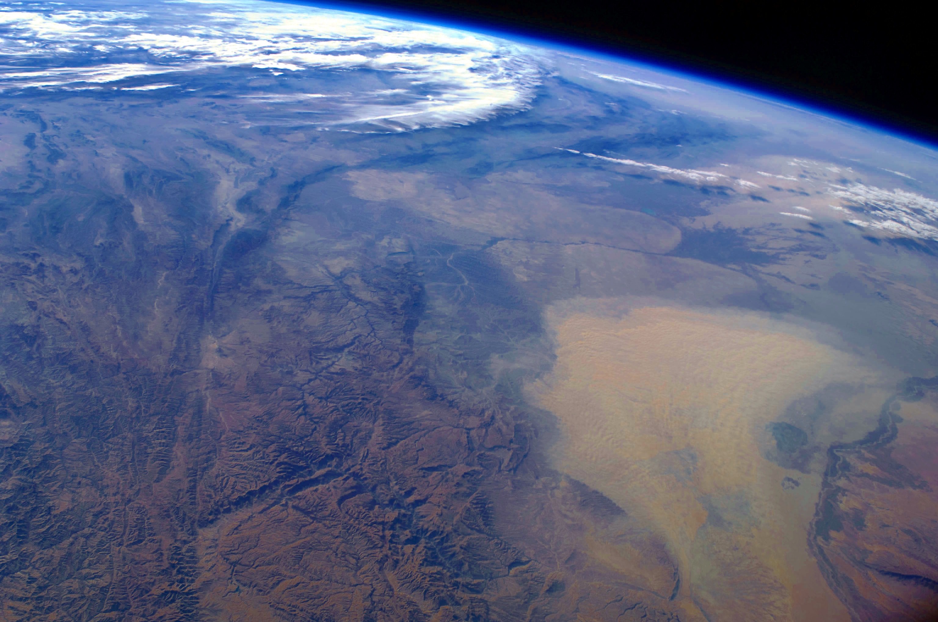
Tamaño de esta previsualización: 800 × 531 píxeles. Otras resoluciones: 320 × 212 píxeles | 640 × 425 píxeles | 1024 × 680 píxeles | 1280 × 850 píxeles | 3072 × 2039 píxeles.
Archivo original (3072 × 2039 píxeles; tamaño de archivo: 911 kB; tipo MIME: image/jpeg)
Éste es un archivo de Wikimedia Commons, un depósito de contenido libre hospedado por la Fundación Wikimedia
Más abajo se reproduce su página de descripción con la información sobre su origen y licencia.
Resumen
| Descripción | English: This west-looking astronaut photograph, taken with a short focal length lens from the International Space Station, spans a wide swath of central Asia—from Afghanistan, along the length of Turkmenistan, and beyond to the Caspian Sea. Winds blowing down the largest river valley in the region, the Amudarya, were strong enough to raise a large dust storm. Dust appears as a light brown mass extending into the center of the image from the lower right. Diffuse dust from prior windy weather appears over much of the area making a regional haze that hides landscape details. The haze partly obscures the irrigated agriculture in Turkmenistan and entirely obscures the Caspian Sea. Numerous rivers rise in the Hindu Kush range (lower left). The Band-i Amir River is a major tributary of the main regional river, the Amudarya, which it reaches via a deep canyon. The Amudarya River was the major historical contributor of water to the Aral Sea, but today extensive diversion of river water for agricultural purposes has led to desiccation of the sea bed. The exposed sea bed is a major source of saline dusts contaminated with agricultural chemicals, and it poses a significant environmental and human health hazard to central Asia. To a lesser extent, dusts are also mobilized from sediments along the Amudarya River channel. The Paropamisus Range and the Amudarya (also known as the Oxus River) are mentioned in histories of Alexander the Great’s famous military expedition from Greece to India. His horsemen are described as having made a fast side excursion from near the Caspian Sea (image top right) as far as the Amudarya (image lower right).
| ||||||||||||||||||||||||||||||||||||||||||||||||||
| Fecha | |||||||||||||||||||||||||||||||||||||||||||||||||||
| Fuente | NASA Earth Observatory | ||||||||||||||||||||||||||||||||||||||||||||||||||
| Autor | This image was taken by the NASA Expedition 17 crew. | ||||||||||||||||||||||||||||||||||||||||||||||||||
| Posición de la cámara | | Ubicación de esta y otras imágenes en: OpenStreetMap |
|---|
Astronaut photograph ISS017-E-19616 was taken with a Nikon D2Xs digital camera fitted with a 28 mm lens, and is provided by the ISS Crew Earth Observations experiment and Image Science & Analysis Laboratory, Johnson Space Centre.
Este archivo fue catalogado por Johnson Space Center de la Administración Nacional de Aeronáutica y del Espacio (NASA) de los Estados Unidos de Américabajo el identificador de foto: ISS017-E-19616.Esta etiqueta no indica el estado de los derechos de autor del trabajo adjunto. Se requiere una etiqueta de derechos de autor normal. Para más información vea Commons:Sobre las licencias. Otros idiomas:
|
Licencia
| Este archivo es de dominio público porque fue creado por la NASA. Las políticas sobre copyright de la NASA estipulan que «el material de la NASA no está protegido con copyright a menos que se indique lo contrario». (Políticas sobre copyright de la NASA o Políticas sobre la utilización de imágenes del Jet Propulsion Laboratory). | ||
 | Advertencias:
|
Historial del archivo
Haz clic sobre una fecha y hora para ver el archivo tal como apareció en ese momento.
| Fecha y hora | Miniatura | Dimensiones | Usuario | Comentario | |
|---|---|---|---|---|---|
| actual | 09:39 18 ene 2011 | | 3072 × 2039 (911 kB) | Originalwana | higher res |
| 14:56 26 abr 2009 |  | 1440 × 960 (597 kB) | Originalwana | {{Information |Description={{en|1=This west-looking astronaut photograph, taken with a short focal length lens from the International Space Station, spans a wide swath of central Asia—from Afghanistan, along the length of Turkmenistan, and beyond to the |
Usos del archivo
No hay páginas que enlacen a este archivo.
Uso global del archivo
Las wikis siguientes utilizan este archivo:
- Uso en bn.wikipedia.org
- Uso en en.wikipedia.org
- Uso en en.wikiquote.org
- Uso en id.wikipedia.org
- Uso en it.wikipedia.org
- Uso en kn.wikipedia.org
- Uso en ms.wikipedia.org
- Uso en sq.wikipedia.org
- Uso en sr.wikipedia.org
- Uso en ta.wikipedia.org
- Uso en tr.wikipedia.org
- Uso en uk.wikipedia.org
- Uso en vi.wikipedia.org
Metadatos
Explore the world

United states
New York

Japan
Tokyo

Singapore
Singapore
