
 Français
 Italiano
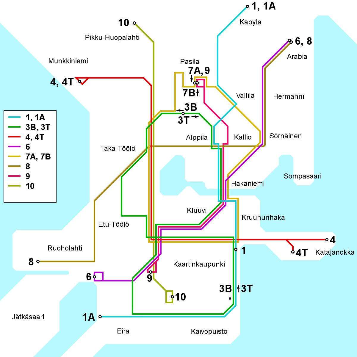
Tamaño de esta previsualización: 600 × 600 píxeles. Otras resoluciones: 240 × 240 píxeles | 480 × 480 píxeles | 768 × 768 píxeles | 1200 × 1200 píxeles.
Archivo original (1200 × 1200 píxeles; tamaño de archivo: 70 kB; tipo MIME: image/png)
Éste es un archivo de Wikimedia Commons, un depósito de contenido libre hospedado por la Fundación Wikimedia
Más abajo se reproduce su página de descripción con la información sobre su origen y licencia.
Resumen
| Descripción | English: A map of the Helsinki tram network as it will appear following the opening of line 9 on 2008-08-10. All names in Finnish. This map will be outdated following the rerouting on lines 3B and 3T, projected to take place on 2009-03-30. After that date, use File:Helsinki tram map.png instead. Suomi: Kartta Helsingin raitiotielinjoista sellaisena kuin se on linjan 9 aloitettua liikennöinnin 10. elokuuta 2008. Tämä kartta tulee vanhenemaan 30. 3. 2009 tapahtuvaksi suunniteltujen linjojen 3B ja 3T reittimuutosten jälkeen. 30. 3. 2009 eteenpäin voimassa oleva kartta on löydettävissä täältä: File:Helsinki tram map.png. |
| Fecha | |
| Fuente | Trabajo propio |
| Autor | Kalle Id |
| Otras versiones | Swedish version: Image:Helsinki tram map 2008-08-10 sv.png |
Licencia
Yo, el titular de los derechos de autor de esta obra, la publico en los términos de la siguiente licencia:
Este archivo se encuentra bajo la licencia Creative Commons Genérica de Atribución/Compartir-Igual 3.0.
- Eres libre:
- de compartir – de copiar, distribuir y transmitir el trabajo
- de remezclar – de adaptar el trabajo
- Bajo las siguientes condiciones:
- atribución – Debes otorgar el crédito correspondiente, proporcionar un enlace a la licencia e indicar si realizaste algún cambio. Puedes hacerlo de cualquier manera razonable pero no de manera que sugiera que el licenciante te respalda a ti o al uso que hagas del trabajo.
- compartir igual – En caso de mezclar, transformar o modificar este trabajo, deberás distribuir el trabajo resultante bajo la misma licencia o una compatible como el original.
 | Esta imagen debería volverse a crear como imágenes vectoriales SVG. Esto proporciona muchas ventajas, véase Commons:Media for cleanup (en inglés) para más información. Si ya hay una versión SVG de esta imagen disponible, por favor súbala a Commons. Tras subirla, reemplace esta plantilla con la plantilla {{vector version available|nuevo nombre de imagen.svg}} en esta imagen. |
Historial del archivo
Haz clic sobre una fecha y hora para ver el archivo tal como apareció en ese momento.
| Fecha y hora | Miniatura | Dimensiones | Usuario | Comentario | |
|---|---|---|---|---|---|
| actual | 17:17 4 oct 2008 | | 1200 × 1200 (70 kB) | Kjet | Improved geographical accuracy in various places + converted line colours to the ones currently used by the HKL |
| 15:44 17 ago 2008 |  | 1200 × 1200 (70 kB) | Kjet | Improved accuracy of the southern terminus of line 9 & the southern loop of line 3. | |
| 07:22 19 jul 2008 |  | 1200 × 1200 (70 kB) | Kjet | {{Information |Description={{en|1=A map of the Helsinki tram network as it will appear following the opening of line 9 on 2008-08-10. All names in Finnish. This map will be outdated following the rerouting on lines 3B and 3T, projected to take place on 20 |
Usos del archivo
La siguiente página usa este archivo:
Uso global del archivo
Las wikis siguientes utilizan este archivo:
- Uso en en.wikipedia.org
- Uso en fi.wikivoyage.org
Explore the world

United states
New York

Japan
Tokyo

Singapore
Singapore
