
 Français
 Italiano
Göygöl National Park
Göygöl National Park

Göygöl National Park (Göygöl Milli Parkı) is in Ganja Region of Azerbaijan.
Understand
[edit]
.jpg)

The meaning of göl is lake.
History
[edit]Lake Göygöl was formed by an earthquake on 30 September 1139, that caused the summit of the mountain Kapaz to collapse in the gorge of the Akhsu river, turning it into a dam.
According to the studies of many authors, the lake has a glacial origin. This opinion is confirmed by Dr. Paffengolts and Dr. Leontyev, who found traces of ancient glaciation in the form of small circuses and cars in the upper reaches of the Shamkirchay River.
Established in 1925, it was Azerbaijan's first national park. In 1965 the park was expanded to 6,739 ha.
The latest increase of the area of the national park was in 2008. Now its total area is 12,755 ha.
Landscape
[edit]Göygöl National Park is on the northeastern part of Lesser Caucasus Mountains and has the forest landscape with several lakes and the rock of Mount Kapaz. Also the area is rich with many river valleys and gorges.
Elevation: 1,000–3,600 m.
Flora and fauna
[edit]The park's wildlife wild mammal and bird species that consists of a lot of these noble Caucasian deer, bear, deer, fox, wild cat, sable, lynx, rabbit, squirrel, birds, and Caspian snowcock, black vulture, partridge etc. can be shown.
Climate
[edit]References
[edit]News on the reopening of the park.
Fees and permits
[edit]2 manat.
Get in
[edit]It is best to take a shared taxi from Göygöl for the 20 km. Göygöl can be reach by local bus from Ganja. A private taxi from Ganja can be as little as 12-14 manat (with Bolt).
In the summer months there are even regular buses up directly to Göygöl lake and the hotel area.
- 1 National Park Administration. Entrance and starting point of all tracks.
Get around
[edit]
Some sites within the park can be reached by car, but mostly you would come here for hiking.
See
[edit]Both lakes Göygöl and Maralgöl are very beautiful, but most pictures of Göygöl are actually of Maralgöl, because it gives much better pictures. Also, Maralgöl is crystal clear and turquoise, just a more impressive mountain lake.
Do
[edit]Hiking
[edit]All official tracks start at the National Park administration building. However, your taxi aka ride might take you further up the road until the bus stop (or hotel area), saving you 1-1½ hr along the Göygöl-Maralgöl trail. Take this offer, since there is not much to see along the serpentines between the park entrance and the hotel area.
In the following the official documentation, and the according listings with the translated information as well as GPS details.
 Göygöl-Maralgöl
 Zəligöl-Gəlinqayası
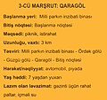 Qaragöl
 Kəpəz dağı


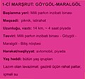
- Göygöl-Maralgöl (pink). Distance: 14 km, Altitude range: 779 m, Total climb: 890 m, Total descent: 111 m. Duration: 4 hr (one way). Grade: Easy. Recommended: comfortable clothes for walking, drinking water. Instead of starting at the park office, it is better to take a ride up until Göygöl lake and save 1-1½ hr. Note, from Maralgöl it is possible to continue (experienced) hiking further into the mountains, heading towards the Kəpəz dağı trail—beware of the Shepard dogs though.
Download coordinates: GPX, KML.
- Zəligöl-Gəlinqayası (brown). Distance: 23 km, Altitude range: 979 m, Total climb: 1,213 m, Total descent: 245 m. Duration: 7-8 hr (one way). Grade: Hard. Recommended: comfortable clothes for walking, drinking water, dining or cooking pot. At the end of the trail, you will climb Mt. Omar.
Download coordinates: GPX, KML.
- Qaragöl (yellow). Distance: 3 km, Altitude range: 381 m, Total climb: 404 m, Total descent: 223 m. Grade: Medium. Recommended: comfortable clothes for walking, drinking water.
Download coordinates: GPX, KML.
- Kəpəz dağı (red). Distance: 15 km, Altitude range: 1,834 m, Total climb: 2,020 m, Total descent: 186 m. Duration: 5 hr (one way). Grade: Hard. Recommended: comfortable clothes for walking, drinking water, snacks.
Download coordinates: GPX, KML.
There are many more hiking trails to be found, just checkout OpenStreetMap and/or any Satellite pictures, e.g. Esri works well in this region, which is used by ACME Mapper.
Since the land is wide open and trees become sparse the higher you go, you may want to combine the Göygöl-Maralgöl and the Kəpəz dağı trails to do a loop simply by taking the most direct route across the ridge or just south of it. Or instead of following the Kəpəz dağı trail back to its origin, just follow the various trails northwest towards the nearby villages.
With the Karabakh situation relaxing further in the future, it might even possible to follow the Zəligöl-Gəlinqayası trail further south towards Dadivank monastery, if still existent then.
Buy
[edit]Eat
[edit]Drink
[edit]Sleep
[edit]Camping
[edit]Camping should not pose an issue further in on one of the longer trails.
Lodging
[edit]Goygol lake accommodation is only open 2-3 months in summer.
- 1 Lotos Otel Ailevi Merkezi (before the entrance), ☏ +994 50 2272777.
- 2 Cennet Mekani (near the entrance), ☏ +994 50 6423707. Not highly recommended.
- 3 [formerly dead link] Family Cottages by Göygöl Lake, Göygöl-Maralgöl Rd (near the lake), ☏ +994 55 4509900.
- 4 [formerly dead link] Kapaz Inn & Suites (near the lake), ☏ +994 55 4509900.
- 5 [formerly dead link] Göygöl Resort (near the lake). Not highly recommended.
Stay safe
[edit]Even though close to the border with Nagorno-Karabakh and previously closed to the public, it is now safe to enter and for leisure. However, you should verify the current situation with the local people, e.g. when arriving in Ganja.
There is extensive fencing around the hotels just near Göygöl (lake), but this seems to be mainly for the guests and not to secure the trails or anything beyond.
Stay away from sheep herds and camps: the dogs are aggressive. However, picking up a stone (such that the dogs see it) will trigger their hesitation. Otherwise, when there is the need to cross a herd, collude with the shepherd.
Some say that bears are active in the area and even at Maralgöl prints can be found, so take precautions.
Explore the world

United states
New York

Japan
Tokyo

Singapore
Singapore
